
What You Missed
Spring 2026
Spring 2026
![]()
![]()
![]()
![]()
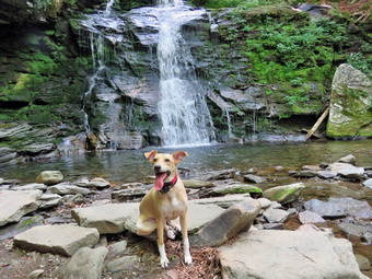
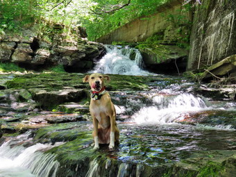
![]() On Wednesday, June 17th, I wanted to get in another slightly longer hike after doing 4 miles the day before. I had ambulance coverage from 8:30 AM to 2:30 PM so my I plan seemed doable. As often happens, a mutual aid call left me very tired as the transport was to Middletown and I did not get home until 3:00 AM. I tried to get some extra sleep but finally got up at 9:00 AM. I decided to just go to Parksville and hike the rail trail even though it is under three miles out and back. I asked Cindy if she would like to go and she said "Yes". I knew the Little Beaverkill would be low as it had not rained much since our last trip. I did want to see how the Town of Liberty's work on the bridge was coming along. By the time we started to get ready at 10:30 AM the temperature was right 64 degrees on the back porch with blue skies amd plenty of sun. As we were getting dressed, Sheena sniffed my clothes and became very excited. I got dressed in my Columbia OmniShade long-sleeved shirt without a baselayer. I put on a pair of RailRiders hiking pants which are expensive but last a long time and have features like deep pockets and a generous cut which I really like. I decided to put on my Keen Durand hiking boots which fit well. I added a new pair of Xstance insoles in an effort to find the best support and cushioning for my feet. These insoles have shock absorbing gel pads, TPU arch support, and memory foam cushioning all wrapped in a breathable fabric. The insoles have been hyped by their manufacturer and seemed to be living up to their claims. I grabbed a pair of Leki Makalu Lite poles I have been using for some time because they are light and lock without slipping. I decided to wear my OR BugOut gaiters as a defense against the ticks that are looking for a warm home and a meal! I put the ecollar on Sheena and turned it on. I put our gear in the back of the car and Sheena in the back seat. We left Livingston Manor at 10:45 AM and drove out Old Route 17 toward Parksville. Just after Fox Mountain Road, I pulled into the parking area on the right side of the road. There wer no cars parked in the lot. We started out on the trail at 11:03 AM under blue skies with lots of sun and a slight breeze blowing.
On Wednesday, June 17th, I wanted to get in another slightly longer hike after doing 4 miles the day before. I had ambulance coverage from 8:30 AM to 2:30 PM so my I plan seemed doable. As often happens, a mutual aid call left me very tired as the transport was to Middletown and I did not get home until 3:00 AM. I tried to get some extra sleep but finally got up at 9:00 AM. I decided to just go to Parksville and hike the rail trail even though it is under three miles out and back. I asked Cindy if she would like to go and she said "Yes". I knew the Little Beaverkill would be low as it had not rained much since our last trip. I did want to see how the Town of Liberty's work on the bridge was coming along. By the time we started to get ready at 10:30 AM the temperature was right 64 degrees on the back porch with blue skies amd plenty of sun. As we were getting dressed, Sheena sniffed my clothes and became very excited. I got dressed in my Columbia OmniShade long-sleeved shirt without a baselayer. I put on a pair of RailRiders hiking pants which are expensive but last a long time and have features like deep pockets and a generous cut which I really like. I decided to put on my Keen Durand hiking boots which fit well. I added a new pair of Xstance insoles in an effort to find the best support and cushioning for my feet. These insoles have shock absorbing gel pads, TPU arch support, and memory foam cushioning all wrapped in a breathable fabric. The insoles have been hyped by their manufacturer and seemed to be living up to their claims. I grabbed a pair of Leki Makalu Lite poles I have been using for some time because they are light and lock without slipping. I decided to wear my OR BugOut gaiters as a defense against the ticks that are looking for a warm home and a meal! I put the ecollar on Sheena and turned it on. I put our gear in the back of the car and Sheena in the back seat. We left Livingston Manor at 10:45 AM and drove out Old Route 17 toward Parksville. Just after Fox Mountain Road, I pulled into the parking area on the right side of the road. There wer no cars parked in the lot. We started out on the trail at 11:03 AM under blue skies with lots of sun and a slight breeze blowing.
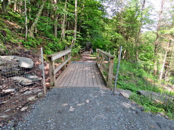
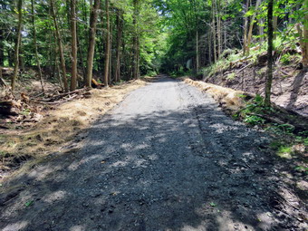 The first part of the trail was just damp but drying quickly. We continued hiking and once we were on the trail and sheltered by the trees it was a little cooler with the breeze blowing. The trail was about as I expected some damp areas and some mud. I was surprised that there seemed to be less water and mud than during our last trip. The rail trail runs parallel to the Little Beaverkill and the new section of State Route 17. It follows the route of the O&W railroad and is very flat. The water level in the stream was not quite as high as the last time we had hiked along the trail. We looked up at one point and saw a group of people hiking toward us with 4 dogs! The dogs were leashed and there was only a little barking as they passed. We said "Hello" to the Poole and they responded in kind. As we continued to hike, we passed several benches placed for people to rest in warmer weather. I stopped at the area just before the wooden walkways and bridge but decided there was nothing different or more interesting than on many trips before. We could see no activity at the other end of the walkway so I knew the Town of Liberty crew was no working in the area of the bridge. We walked across the long walkway but stopped when we came to the ridge. The crew had finished their work and appeared to have done great job! They had cleared all of the debris that was blocking the culvert udder the bridge. Large boulders now held back the dirt and stones that often wash down the hillside to block the flow of water through the culvert. The crew had added crushed stone on either side of the bridge to smooth the way on and off the brdige. More stone had been added to fill in the mud pit on the Parksville side. Some fencing had been added and the overall effect was very pleasing. I stopped to take a number of pictures before continuing. In a very short distance we came to the area where a large mudslide had brought trees and dirt down onto the trail. This area had been partly cleared in the past but the Liberty crew had graded it and added some crusher run. They also removed much of the debris, erected some fencing, and added some hay to help grass to grow back. As we continued I noticed several other places where they had done some work. Somehow they had magically erased all the ruts made by the heavy machinery. These guys take great ride in their work and it really show. We continued on the trail heading toward the falls. As we walked toward the falls, we could hear an increase in the noise from the stream and I knew the falls was just ahead. There were three adults standing by the picnic table and they began to walk in our direction. Sheena and I stepped off the trail and I told her to sit. She remained perfectly as they passed. When I released her, she ran ahead and bolted down the path toward the base of the falls and I followed her lead.
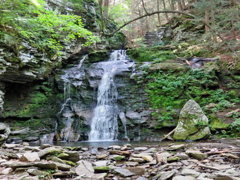
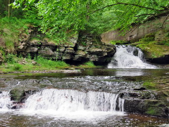 The path down to the falls is not easy but at least it was dry in this day. Sheena just runs down to Te streambed but I pick my way carefully. At the bottom I put my pack down and got out the camera. The water level was low but the falls were still making noise. I walked out onto some rocks and then took pictures downstream. I also took some shots of the stone wall across the stream which give a good idea of the water level. I turned 180 degrees and began to take pictures of the falls and rapids. I used different zooms and changed positions a couple of times to get a variety of views. I was about to packed up when Sheena ran to one of the rocks and sat down to pose for pictures. I took a closeup and several others until she seemed satisfied. I put the camera away and scoured the pack to get back up to the trail. Cindy was sitting on the picnic bench. I got out
my camera again to take some pictures of the falls and rapids upstream of the falls from above. Eventually I was dine. I stowed the camera and we headed to the Parksville trailhead. Soon we were nearing the Parksville end of the trail. Many of the rundown buildings had beem removed or were being renovated. Several of the buildings showed that work had been done on them. The large dog across the stream was not present and I missed him. On the Parksville end of the trail we found the small garden and a very informative sign. The pack of barking dogs that always greets us was absent. The sign listed the businesses and hotels that existed in Parksville during its heyday. The Young's Gap Hotel had room for 600 guests! The sign also explained the role of the railroad in the dairy industry which was a thriving one in all of Sullivan County. It was 11:53 AM when we headed back toward the car. We had covered the walk out in 50 minutes but I knew the walk back would be quicker without stops for photography. Just after passing the falls we met the three adults coming back toward us. I thought they probably didn't walk all the way to the other end but they seemed content and we again greeted each other. We set a faster pace on the way back but that did not stop Sheena from going into full zoomie mode. She was racing ahead and then sprinting back toward us. She added some growing and attempts to bite our feet! Just before the mudslide and the bridges, The group with the dogs was stopped at a picnic table. I put Sheena on her leash and walked by then quickly. Sheena was more intent on hiking than paying attention to Te other dogs. We continued to keep a good pace. We crossed the bridge and the wooden walkway and saw two people walking ahead of us. They were headed in the same direction at only a slightly slower pace. As we neared the end of the wooded part of trail, I gave Sheena the "With" command and she fell in behind me. We were back at the car at 12:28 PM having walked the return route in 35 minutes. The whole hike took us 1 hour and 25 minutes which I judged good for the amount of stops for photography.
The path down to the falls is not easy but at least it was dry in this day. Sheena just runs down to Te streambed but I pick my way carefully. At the bottom I put my pack down and got out the camera. The water level was low but the falls were still making noise. I walked out onto some rocks and then took pictures downstream. I also took some shots of the stone wall across the stream which give a good idea of the water level. I turned 180 degrees and began to take pictures of the falls and rapids. I used different zooms and changed positions a couple of times to get a variety of views. I was about to packed up when Sheena ran to one of the rocks and sat down to pose for pictures. I took a closeup and several others until she seemed satisfied. I put the camera away and scoured the pack to get back up to the trail. Cindy was sitting on the picnic bench. I got out
my camera again to take some pictures of the falls and rapids upstream of the falls from above. Eventually I was dine. I stowed the camera and we headed to the Parksville trailhead. Soon we were nearing the Parksville end of the trail. Many of the rundown buildings had beem removed or were being renovated. Several of the buildings showed that work had been done on them. The large dog across the stream was not present and I missed him. On the Parksville end of the trail we found the small garden and a very informative sign. The pack of barking dogs that always greets us was absent. The sign listed the businesses and hotels that existed in Parksville during its heyday. The Young's Gap Hotel had room for 600 guests! The sign also explained the role of the railroad in the dairy industry which was a thriving one in all of Sullivan County. It was 11:53 AM when we headed back toward the car. We had covered the walk out in 50 minutes but I knew the walk back would be quicker without stops for photography. Just after passing the falls we met the three adults coming back toward us. I thought they probably didn't walk all the way to the other end but they seemed content and we again greeted each other. We set a faster pace on the way back but that did not stop Sheena from going into full zoomie mode. She was racing ahead and then sprinting back toward us. She added some growing and attempts to bite our feet! Just before the mudslide and the bridges, The group with the dogs was stopped at a picnic table. I put Sheena on her leash and walked by then quickly. Sheena was more intent on hiking than paying attention to Te other dogs. We continued to keep a good pace. We crossed the bridge and the wooden walkway and saw two people walking ahead of us. They were headed in the same direction at only a slightly slower pace. As we neared the end of the wooded part of trail, I gave Sheena the "With" command and she fell in behind me. We were back at the car at 12:28 PM having walked the return route in 35 minutes. The whole hike took us 1 hour and 25 minutes which I judged good for the amount of stops for photography.
![]()
![]()
![]()
![]()
![]() On Tuesday, June 16th, I wanted to get out for a longer hike after sticking to shorter hikes on the rail trail. I was supposed to have ambulance coverage from 8:00 AM to 2:00 PM which would allow me 6 hours to drive and hike. I intended to get up early and go to either Bramley Mt or Balsam Lake Mt since they both have fire towers. We had a call just before midnight which got me home and asleep by around 2:00 AM. The next call came in at 5:00 Am and was a serious and stressful call. As I was writing up the documentation for this call at base, a call came in for another corps and three corps were paged but could not cover. We were dispatched on a 20+ minute drive. I finally returned home at 9:30 AM it was very foggy but the temperature was 73 degrees on the back porch. I was too tired and it was too late to hike very far. I thought I might try a shorter hike in the Frick Pond area. I intended to hike up Flynn Trail, down Big Rock to Times Square, across Toes Square and along the Big Rock Trail to the Quick lake trail, We would turn right on the Quick Lake Trail and follow it back to the car passing by Frick Pond on the way. As usual, Sheena was excited but was trying to be the "good dog". I decided to wear a Columbia Omni-Shade Omni-Wick crew shirt without a baselayer. I wore my Railriders hiking pants which are expensive but last along time and have features like deep pockets and a generous cut which I really like. The pants have Velcro closures at the ankles. I thought about warmer pants but decided against it. I decided to put on my Keen Durand hiking boots which fit well. I added a new pair of Xstance insoles in an effort to find the best support and cushioning for my feet. These insoles have shock absorbing gel pads, TPU arch support, and memory foam cushioning all wrapped in a breathable fabric. The insoles have been hyped by their manufacturer and seemed to be living up to their claims. I grabbed a pair of Leki Makalu Lite poles I have been using for some time because they are light and lock without slipping. I put on my OR BugOut gaiters as I knew that the trails would be dry but the ticks would be out! I also decided to wear my OR floppy hat. I put my gear in the back and Sheena in the backseat and headed out the DeBruce Road at 10:10 AM. After 6 miles, at Mongaup Pond Road, I turned left and continued to follow the road bearing left onto Beech Mountain Road at the fork. When we arrived in the parking area there were no cars parked in either lot. Sheena was acting as if she hadn't hiked in a month as she ran around and headed for the trail. The temperature was 61 degrees and the skies were now mostly blue with white clouds and a slight breeze blowing. I set my GPS as we got ready to head out on the Flynn Trail. We crossed the road and began our hike at 10:30 AM.
On Tuesday, June 16th, I wanted to get out for a longer hike after sticking to shorter hikes on the rail trail. I was supposed to have ambulance coverage from 8:00 AM to 2:00 PM which would allow me 6 hours to drive and hike. I intended to get up early and go to either Bramley Mt or Balsam Lake Mt since they both have fire towers. We had a call just before midnight which got me home and asleep by around 2:00 AM. The next call came in at 5:00 Am and was a serious and stressful call. As I was writing up the documentation for this call at base, a call came in for another corps and three corps were paged but could not cover. We were dispatched on a 20+ minute drive. I finally returned home at 9:30 AM it was very foggy but the temperature was 73 degrees on the back porch. I was too tired and it was too late to hike very far. I thought I might try a shorter hike in the Frick Pond area. I intended to hike up Flynn Trail, down Big Rock to Times Square, across Toes Square and along the Big Rock Trail to the Quick lake trail, We would turn right on the Quick Lake Trail and follow it back to the car passing by Frick Pond on the way. As usual, Sheena was excited but was trying to be the "good dog". I decided to wear a Columbia Omni-Shade Omni-Wick crew shirt without a baselayer. I wore my Railriders hiking pants which are expensive but last along time and have features like deep pockets and a generous cut which I really like. The pants have Velcro closures at the ankles. I thought about warmer pants but decided against it. I decided to put on my Keen Durand hiking boots which fit well. I added a new pair of Xstance insoles in an effort to find the best support and cushioning for my feet. These insoles have shock absorbing gel pads, TPU arch support, and memory foam cushioning all wrapped in a breathable fabric. The insoles have been hyped by their manufacturer and seemed to be living up to their claims. I grabbed a pair of Leki Makalu Lite poles I have been using for some time because they are light and lock without slipping. I put on my OR BugOut gaiters as I knew that the trails would be dry but the ticks would be out! I also decided to wear my OR floppy hat. I put my gear in the back and Sheena in the backseat and headed out the DeBruce Road at 10:10 AM. After 6 miles, at Mongaup Pond Road, I turned left and continued to follow the road bearing left onto Beech Mountain Road at the fork. When we arrived in the parking area there were no cars parked in either lot. Sheena was acting as if she hadn't hiked in a month as she ran around and headed for the trail. The temperature was 61 degrees and the skies were now mostly blue with white clouds and a slight breeze blowing. I set my GPS as we got ready to head out on the Flynn Trail. We crossed the road and began our hike at 10:30 AM.
 The Flynn Trail is sited along what used to be Beech Mountain Road which was the access for the Beech Mountain Boy Scout Camp. We walked the trail through the woods which was damp in places but not muddy. We started out slowly because my muscles felt tired but soon were keeping a good pace. We turned right on the woods road and began a consistent climb at a slightly slower pace than usual. The path was narrow and it was obvious a stream of water had run down the trail during the recent rains. The trail gains a little over 600 feet in 1.7 miles to the highest point at the junction with the Big Rock Trail. We passed the hemlock that used to form a tunnel but was cleared by the DEC. We began to find some small branches on the trail which had come down in the winds from various storms. We continued to find similar conditions for the rest of the hike. The day was getting warmer as the sun came out full force. I began to warm up even though I only had a single layer. On the way up the trail we came to the rock ledges on the right side of the trail. I sometimes take pictures here but decided that I might not take any pictures on this day. As we approached and the clearing to the right of the trail, I debated walking up to the field but decided against it. It was a beautiful day and the sun was shining on the rocks and the trail. I noticed that I was very relaxed and decided it was partly due to the sounds of the winds and the birds. Sheena was keeping mostly to the trail but also was making some detours to chase game. Since the grass and ferns were taller than her, Sheena would periodically jump straight up to see where she was going. Sheena would take the time to come back to check on me occasionally. We descended a little and then began walking uphill. We were soon at the junction with the Big Rock Trail. I was a little tired and I needed to be back before 2:00 PM so I decided to leave the 6 mile loop for another day. We turned left to walk down the Big Rock Trail. It was 11:30 AM and we had hiked 1.75 miles uphill in an hour. This was much slower than usual but I was enjoying the relaxed pace.
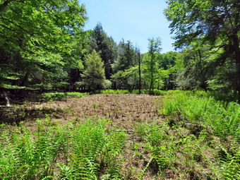
 The Big Rock Trail was only a little damp as we started down the long descent. The hike down the trail went well and more quickly than I expected. It was definitely easier than the uphill hike! This trail can be tricky as there are three levels that make it seem like the bottom of the hill. On this day the descents seemed to go quickly and I was not discouraged. We were soon at Times Square and I thought about turning right to hike up and around the Logger's Loop to add some distance to our hike. I decided against this as it was getting late and we continued our hike by walking straight across Times Square to stay on the Big Rock Trail. The Big Rock Trail around the back of Frick Pond can be very wet but this day there was barely any mud. Sheena hiked right through the water and mud that was present and was getting filthy! We crossed the two small bridges over the inlets to the pond and I decided not to stop to take any pictures. The first of the inlet streams had plenty of water but was flowing slowly. The second inlet stream had much less water and it was barley moving. When we got to the area that was covered by tall evergreens, I pushed on through as I had taken pictures here very recently. At one point Sheena was chasing a squirrel which ran up a tree. Sheena came to the tree, ran up the tree about four feet, and the jumped back to the ground! This is the first instance I had seen of her tree-climbing Fiest label. The wooden boardwalks continue to show wear with many boards loose and other beginning to rot. Much of the boardwalk now "floats" in midair as the supports are rotting. The local rangers and the DEC field office have been alerted several times but don't really seem to care as any work including repalcement are not in "The Plan".
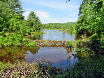
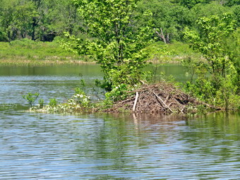
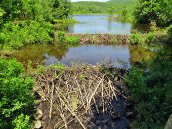
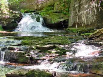
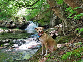
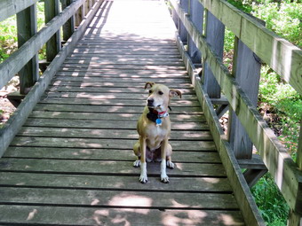 The rest of the trail was damp with several wet and muddy spots. We could hear some loud voices and I eventually concluded they were walking the Quick Lake Trail. At the next trail junction we turned left on the Quick Lake Trail to head for the bridge across the outlet of Frick Pond. We walked along the west side of Frick Pond to the bridge across the outlet of the pond. The mudhole was wet but not muddy as the drainage work and the stepping stones did their job. I stopped at the bridge to admire two new beavers dams that had been constructed. Unfortunately, the dam closest to the brdige had been ripped out just as it had been last year! There were tracks in the dirt indicating that someone had brought in a large machine to do this dirty deed! The main dam was still intact and was holding back most of the water. The level of the water made it look like Frick Pond again. I hope that no one will disturb the main dam as they have done in the past. I dropped my pack and got out the camera. I took a few shots of Sheena on the bridge. I then took pictures of the pond and the dams at various angles and zooms. I also photographed Beech Mountain and the outlet downstream of the bridge. When I was done, put the camera away and shouldered my pack. Sheena and I then walked up the hill and continued to Gravestone Junction. The tracks of the machinery were still very obvious and had chewed up the trail with no regard to the work done by maintainer. We passed the Lobdell Memorial marker just after Gravestone Junction. The marker is a memorial to two children who died in the 1930's in a fire that consumed their cabin. The trail to the memorial was well-worn but the marker was standing intact. The trail back to the register was damp and muddy in spots but not as wet as I expected. We passed the trail register heading toward the parking area and continued straight ahead to follow the woods road out to the car. We arrived at the car at 12:40 PM having hiked 4.1 miles in 2 hours with an elevation gain of 640 feet. Our overall average speed was just under 2 MPH with a moving average of 2 MPH. The temperature had risen to 68 degrees! I called the local ranger about the missing dam. He was not aware of the problem but assured me he would look into the situation.
![]()
![]()
![]()
![]()
![]() On Thursday, June 11th, I planned to go on a longer hike since I had coverage for ambulance calls from 8:30 AM to 2:30 PM. The forecast called for a sunny day with clouds and a chance of showers late in the afternoon. I decided to go to Trout Pond to walk the loop in a clockwise direction. I was interested to see the effect of alternating rain storms and dry spells was having on the water levels in the lakes and streans. When I got up at 9:00 AM, the skies were bright and sunny with a few white clouds. The temperature was 78 degrees but the humidity seemed high compared to the last few days. I was little worried about this combination of heat and humidity. I started to get ready at 9:30 AM with Sheena acting very enthusiastic about getting out as it had been almost a week. I decided to wear a Columbia Omni-Shade Omni-Wick crew shirt without a baselayer. I wore my Railriders hiking pants which are expensive but last along time and have features like deep pockets and a generous cut which I really like. The pants have Velcro closures at the ankles. I thought about warmer pants but decided against it. I decided to put on my Keen Durand hiking boots which fit well. I added a new pair of Xstance insoles in an effort to find the best support and cushioning for my feet. These insoles have shock absorbing gel pads, TPU arch support, and memory foam cushioning all wrapped in a breathable fabric. The insoles have been hyped by their manufacturer and seemed to be living up to their claims. I grabbed a pair of Leki Makalu Lite poles I have been using for some time because they are light and lock without slipping. I put on my OR BugOut gaiters as I knew that the trails would be dry but the ticks would be out! I also decided to wear my OR floppy hat. I put my gear in the back and Sheena in the backseat and pulled out of Livingston Manor at 9:50 AM. I headed to Roscoe on State Route 17, got off at exit 94 and got on Route 206. I followed it across the Delaware County line to Morton Hill Road. After a left turn on Morton Hill Road, I drove toward the intersection with Russell Brook Road. There were no cars parked in the "lot" at the intersection. This area is private property but people insist on parking there despite the signs. I turned left on Russell Brook Road to drive to the lower parking area. There were no tents set up at the first camping area on the right and none at the first area on the left.
On Thursday, June 11th, I planned to go on a longer hike since I had coverage for ambulance calls from 8:30 AM to 2:30 PM. The forecast called for a sunny day with clouds and a chance of showers late in the afternoon. I decided to go to Trout Pond to walk the loop in a clockwise direction. I was interested to see the effect of alternating rain storms and dry spells was having on the water levels in the lakes and streans. When I got up at 9:00 AM, the skies were bright and sunny with a few white clouds. The temperature was 78 degrees but the humidity seemed high compared to the last few days. I was little worried about this combination of heat and humidity. I started to get ready at 9:30 AM with Sheena acting very enthusiastic about getting out as it had been almost a week. I decided to wear a Columbia Omni-Shade Omni-Wick crew shirt without a baselayer. I wore my Railriders hiking pants which are expensive but last along time and have features like deep pockets and a generous cut which I really like. The pants have Velcro closures at the ankles. I thought about warmer pants but decided against it. I decided to put on my Keen Durand hiking boots which fit well. I added a new pair of Xstance insoles in an effort to find the best support and cushioning for my feet. These insoles have shock absorbing gel pads, TPU arch support, and memory foam cushioning all wrapped in a breathable fabric. The insoles have been hyped by their manufacturer and seemed to be living up to their claims. I grabbed a pair of Leki Makalu Lite poles I have been using for some time because they are light and lock without slipping. I put on my OR BugOut gaiters as I knew that the trails would be dry but the ticks would be out! I also decided to wear my OR floppy hat. I put my gear in the back and Sheena in the backseat and pulled out of Livingston Manor at 9:50 AM. I headed to Roscoe on State Route 17, got off at exit 94 and got on Route 206. I followed it across the Delaware County line to Morton Hill Road. After a left turn on Morton Hill Road, I drove toward the intersection with Russell Brook Road. There were no cars parked in the "lot" at the intersection. This area is private property but people insist on parking there despite the signs. I turned left on Russell Brook Road to drive to the lower parking area. There were no tents set up at the first camping area on the right and none at the first area on the left.
 I decided not to stop on the right side of the road near the upper drop of Russell Brook Falls although a quick peek showed the water was very low. I continued down to the lower parking area where mo cars were parked. We got out of the car and I let Sheena out so she could roam around. My glasses immediately fogged up as I had been using the air conditioning in the car. I set my GPS unit so I could record our hike. We started down the woods road toward the bridge across Russell Brook at 10:13 AM with the temperature at 76 degrees. We crossed the bridge and found that the Japanese knotweed was not growing out into the trail as I had expected. It did not seem that anybody had cut it back. Just hiking this short distance I found that I was tired and my muscles were tired. I decided to continue but bypass the falls for a possible visit at the end of the hike. At the main trail we turned right and then left where the trail split. We started out on the Mud Pond Trail by crossing the bridge over the outlet stream from Trout Pond. There was very little water flowing in the stream. As we passed by the large campsite on the right, we noted that no one was camped. I was surprised since this is one of the most popular campsites. The trail began to climb the hill and in .6 miles we gained over 350 feet. I had to stop for short periods a couple of times. I seriously questioned whether I should continue but decided I could. There are several streams that run across the trail and all were dry and there was no water on the trail at all. The trail itself was dry and extremely rocky which made walking difficult. Sheena was hiking her own hike by ranging out ahead of me and following game trails and game into the woods. At one point she flushed some grouse and took off after them. It took several calls and a beep on the collar to get her back to the trail. Soon we were at the top of the hill and began a slight descent toward the trail junction. Walking that descent felt really good and was a respite from the climbing. The trail remained dry even in places that were normally wet. When we reached the trail junction, we turned right on the Mud Pond Trail and began a long climb that was shallower than the initial climb. There were numerous locations where there were large trees across the trail that had been cut and removed. The DEC is responsible for trail maintenance and often send a work crew on a UTV to clear these trails. As we walked, a light breeze started which felt remarkably refreshing! The trail continued to be very dry with a few small branches that came down in recent winds. The climb seemed to go on for a long time and when we got to the top I was glad the rest of the hike was downhill or flat.
 As we began our descent, we found the trails continued to be dry. The descent from the highest point on the hike to the outlet bridge is .7 miles and loses 455 feet in elevation. The trail is rocky but I made surprisingly good time on the descent. On the final descent to the pond, we made a slight right turn to start down to the pond. We arrived at the outlet end of the pond where we walked across the bridge. I decided that I felt good and wanted to stay that way so I did not want to stop for pictures. The inlet stream was very low and I could see that the level of the pond was also low. We continued across the bridge over the inlet stream and started toward the outlet end of the pond. Just as we made the turn, a solo woman hiker came toward us. She appareled to be running or at least fact walking. We said "hello" to each other as she passed by. I had been taking drinks along the way and now I directed Sheena to walk down to the pond for a drink. She went down to the shore and walked into the water to get a drink. She came back to the trail and continued to hike. We found the large campsite on the left of the trail unused. At one point there was a place to walk off the trail to take some pictures of the pond but I decided we would continue to the "beach" at the end of the lake. We continued down the trail and bypassed the beach without taking pictures. The pond was low enough so that there was at least 10 feet of beach and no water was going over the spillway! We continued on the main trail setting a rapid pace as this part of the trail has less rocks. The trail descends gently losing 260 feet over .7 miles on a wide woods road. At some point near the top of the trail, we saw a family of four walking down the trail ahead of us. Sheena immediately came back to me and stayed behind me as long as she could see the family. They were hiking a little slower than us but we stayed behind them until we passed the junction with the Mud Pond Trail and walked by the trail register. The family turned left to go to the falls but we continued on the trail and back to the car. We arrived at 12:45 PM after walking 4.5 miles in 2 hours and 30 minutes. The elevation gain was about 800 feet. The temperature at the car was 86 degrees which was a 10 degree increase from the time we started! On the way home I stopped for an electrolyte drink and some jerky. The drink was definitely worth it and I found out that Sheena loves jerky.
![]()
![]()
![]()
![]() On Tuesday, June 9th I wanted to get out for a longer hike and to extend my consecutive days with a hike to two. I promised myself that I would try to get out as many days as possible this summer despite the numerous ambulance calls. I had coverage for ambulance calls from 8:30 AM to 6:00 PM but had to cover from 6:00 AM to 8:30 AM. Unfortunately we had a call in the middle of the night which disrupted my sleep. I hoped I could get some sleep in the mroning to make up for the call in the middle of the night. At 7:00 Am we had a mutual aid call to Roscoe and I did not get home until 9:30 AM. Cindy was going to church for Bible study but she agreed to go hiking when she got home! I laid down for a nap and did not wake up until she got home at 1:00 PM! The forecast was for blue skies and sun in the afternoon so we began to get ready at 1:30 PM with the temperature at 82 degrees on the back porch. I got dressed in a new Columbia OmniShade long-sleeved shirt without a baselayer. I put on a pair of RailRiders hiking pants which are expensive but last a long time and have features like deep pockets and a generous cut which I really like. I decided to put on my Keen Durand hiking boots which fit well. I added a new pair of Xstance insoles in an effort to find the best support and cushioning for my feet. These insoles have shock absorbing gel pads, TPU arch support, and memory foam cushioning all wrapped in a breathable fabric. The insoles have been hyped by their manufacturer and seemed to be living up to their claims. I grabbed a pair of Leki Makalu Lite poles I have been using for some time because they are light and lock without slipping. I decided to wear my OR BugOut gaiters as a defense against the ticks that are looking for a warm home and a meal! I put the ecollar on Sheena and turned it on. At 2:00 PM I put our gear in the car and Sheena in the back seat. I headed out Old Route 17 across the Flats and then took Old Route 17 and Service Road to the point where they meet Fox Mountain Road. Just after this intersection is the western parking area for the rail trail. The parking lot had three other cars parked which didn't surprise as it was such a nice day. As I parked a group of four people and two dogs came walking back to two cars.
On Tuesday, June 9th I wanted to get out for a longer hike and to extend my consecutive days with a hike to two. I promised myself that I would try to get out as many days as possible this summer despite the numerous ambulance calls. I had coverage for ambulance calls from 8:30 AM to 6:00 PM but had to cover from 6:00 AM to 8:30 AM. Unfortunately we had a call in the middle of the night which disrupted my sleep. I hoped I could get some sleep in the mroning to make up for the call in the middle of the night. At 7:00 Am we had a mutual aid call to Roscoe and I did not get home until 9:30 AM. Cindy was going to church for Bible study but she agreed to go hiking when she got home! I laid down for a nap and did not wake up until she got home at 1:00 PM! The forecast was for blue skies and sun in the afternoon so we began to get ready at 1:30 PM with the temperature at 82 degrees on the back porch. I got dressed in a new Columbia OmniShade long-sleeved shirt without a baselayer. I put on a pair of RailRiders hiking pants which are expensive but last a long time and have features like deep pockets and a generous cut which I really like. I decided to put on my Keen Durand hiking boots which fit well. I added a new pair of Xstance insoles in an effort to find the best support and cushioning for my feet. These insoles have shock absorbing gel pads, TPU arch support, and memory foam cushioning all wrapped in a breathable fabric. The insoles have been hyped by their manufacturer and seemed to be living up to their claims. I grabbed a pair of Leki Makalu Lite poles I have been using for some time because they are light and lock without slipping. I decided to wear my OR BugOut gaiters as a defense against the ticks that are looking for a warm home and a meal! I put the ecollar on Sheena and turned it on. At 2:00 PM I put our gear in the car and Sheena in the back seat. I headed out Old Route 17 across the Flats and then took Old Route 17 and Service Road to the point where they meet Fox Mountain Road. Just after this intersection is the western parking area for the rail trail. The parking lot had three other cars parked which didn't surprise as it was such a nice day. As I parked a group of four people and two dogs came walking back to two cars.
The temperature was still 82 degrees under blue skies with diffuse white clouds as we began the hike at 2:18 PM. I put Sheena on her leash and we walked under the Quickway on Fox Mountain Road and crossed the bridge over a stream. We stepped over the guard rail and started out on the trail. Almost immediately we came to what was left of the trestle supports that carried the trail tracks over the stream. We started to walk up the trail to the left of the trestle and immediately came to a blowdown that I had trimmed so that hikers could easily get around it. We walked up the trail to the top of the trestle. As we entered the shade of the trees, it immediately seemed a little cooler. The trail is rather well defined and stretches ahead for some distance. Like most rail trails it was very straight. Town of Liberty Supervisor Frank DeMayo had told me that this was state land and the town had an agreement from the state to use it during the summer. I saw no POSTED signs along the right-of-way. The hope is to connect the Parksville Rail Trail to all the sections that stretch as far as Livingston Manor. We started to walk along the trail and I noticed there was quite a bit of loud traffic on the Quickway and on Service Road! The land drops off steeply from the rail trail to the Little Beaverkill on the right. The volume of water in the stream was low due to the lack of rain for almost a week. On the left were some "cliffs" which were the result of the railroad cutting a path for the tracks. We continued to walk along the well-defined trail. It was a pleasant walk except for the humidity which was rather high. There were several blowdowns across the trail which we had to walk around. In other places blowdowns had been cut and pulled off the trail. There are two places along the trail where there were piles of garbage. It is hard to determine why they are there. Both piles had tarps over them which seemed to indicate someone once valued the items. Near the first pile on the right is a VW Bug down over the side of the trail! We soon came to the gate on the trail which is odd since it is state land. No one seems to know why the gate is there or who placed it. We walked around the gate and continued on the trail.
I was hiking faster than Cindy I decided to keep the pace and hike to Old Liberty Road. I could then turn around and hike back to Cindy. Sheena and I set a fast pace and soon we came to a small pond on the right with a red building behind it. The building looked to be in good shape but the windows were all boarded up. The grass on the trail had not been mowed and was almost knee high. After hiking about 1.3 miles, we came to a driveway on the left which leads to the Sonoma Falls property. I knew this was private land and decided not to enter. I wish I could find out who owns the land and get explicit permission to walk around the property. It has been more than 12 years since I had last visited this area on a regular basis. At one time there was a campground on the property. Some local business people bought the property and built a cider mill and market. They took the time to construct some hiking trails along the stream. I remember that the falls were very nice with at least five separate drops which increased in height the farther upstream one ventured. The main building had begun to collapse and others were vandalized so the owners had recently had them torn down. The rubble had not been cleared and was an eyesore. We continued on the main trail toward Old Liberty Road and set a quicker pace. The walk along the old road was interesting as there were some impressive rock cuts on the left. The waterway on the right was moving slowly and the volume was low. The walk was about .4 miles which was a little longer than I thought. When we arrived at Old Liberty Road, I saw that the trail actually continued straight ahead parallel to the road. I decided to explore this part of the trail on another visit. We turned around at 3:03 PM and walked back toward the car. We set a pretty fast pace on the way back and met Cindy not too far away. I slowed down to match her pace but decided to push the pace and wait for her later. There were a few photographic opportunities on the hike but we enjoyed the fast-paced walk. Sheena and I hiked to the point where the trail came down from the rail trail to meet Fox Mountain Road. Sheena and I waited for Cindy and it only took a few minutes for her to catch up. We walked out to the road, jumped the guard rail, and turned left. I put Sheena on her leash to walk out to Service Road We were back at the car at 3:41 PM having hiked 3.3 miles in 1 hours and 23 minutes. The ascent was 140 feet but it is hardly noticeable as the trail feels flat when walking. The temperature had risen to 84 degrees. I do hope the plans to connect the sections of the trails is successful!
![]()
![]()
![]()
![]()
![]() On Monday, June 8th, I wanted to get in a hike after a weekend of ambulance calls and church commitments! I had ambulance coverage from 8:30 AM to 2:30 PM so I planned to get in a longer hike. As often happens, two overnight mutual aid calls left me very tired. I tried to get some extra sleep but finally got up at 9:00 AM. I decided to just go to Parksville and hike the rail trail even though it is under three miles out and back. I knew the Little Beaverkill would be low as it had not rained much since our last trip. By the time I started to get ready at 11:30 AM the temperature was right around 76 degrees on the back porch with blue skies amd plenty of sun. I asked Cindy if she would like to go but she declined which surprised me as the weather was so nice. As wI was getting dressed, Sheena sniffed my clothes and became very excited. I got dressed in a new Columbia OmniShade long-sleeved shirt without a baselayer. I put on a pair of RailRiders hiking pants which are expensive but last a long time and have features like deep pockets and a generous cut which I really like. I decided to put on my Keen Durand hiking boots which fit well. I added a new pair of Xstance insoles in an effort to find the best support and cushioning for my feet. These insoles have shock absorbing gel pads, TPU arch support, and memory foam cushioning all wrapped in a breathable fabric. The insoles have been hyped by their manufacturer and seemed to be living up to their claims. I grabbed a pair of Leki Makalu Lite poles I have been using for some time because they are light and lock without slipping. I decided to wear my OR BugOut gaiters as a defense against the ticks that are looking for a warm home and a meal! I put the ecollar on Sheena and turned it on. I put my gear in the back of the car and Sheena in the back seat. We left Livingston Manor at 11:50 AM and drove out Old Route 17 toward Parksville. Just after Fox Mountain Road, I pulled into the parking area on the right side of the road. There was two cars parked in the lot.We started out on the trail at 1:05 PM under blue skies with lots of sun and a slight breeze blowing.
On Monday, June 8th, I wanted to get in a hike after a weekend of ambulance calls and church commitments! I had ambulance coverage from 8:30 AM to 2:30 PM so I planned to get in a longer hike. As often happens, two overnight mutual aid calls left me very tired. I tried to get some extra sleep but finally got up at 9:00 AM. I decided to just go to Parksville and hike the rail trail even though it is under three miles out and back. I knew the Little Beaverkill would be low as it had not rained much since our last trip. By the time I started to get ready at 11:30 AM the temperature was right around 76 degrees on the back porch with blue skies amd plenty of sun. I asked Cindy if she would like to go but she declined which surprised me as the weather was so nice. As wI was getting dressed, Sheena sniffed my clothes and became very excited. I got dressed in a new Columbia OmniShade long-sleeved shirt without a baselayer. I put on a pair of RailRiders hiking pants which are expensive but last a long time and have features like deep pockets and a generous cut which I really like. I decided to put on my Keen Durand hiking boots which fit well. I added a new pair of Xstance insoles in an effort to find the best support and cushioning for my feet. These insoles have shock absorbing gel pads, TPU arch support, and memory foam cushioning all wrapped in a breathable fabric. The insoles have been hyped by their manufacturer and seemed to be living up to their claims. I grabbed a pair of Leki Makalu Lite poles I have been using for some time because they are light and lock without slipping. I decided to wear my OR BugOut gaiters as a defense against the ticks that are looking for a warm home and a meal! I put the ecollar on Sheena and turned it on. I put my gear in the back of the car and Sheena in the back seat. We left Livingston Manor at 11:50 AM and drove out Old Route 17 toward Parksville. Just after Fox Mountain Road, I pulled into the parking area on the right side of the road. There was two cars parked in the lot.We started out on the trail at 1:05 PM under blue skies with lots of sun and a slight breeze blowing.
 The first part of the trail was just damp but drying quickly. I could immediately see a woman walking toward us with her dog on a leash. Sheena followed my off the trail to let the otters pass by. We continued hiking and once we were on the trail and sheltered by the trees it was a little cooler with the breeze blowing. The trail was about as I expected some damp areas and some mud. I was surprised that there seemed to be less water and mud than during our last trip. The rail trail runs parallel to the Little Beaverkill and the new section of State Route 17. It follows the route of the O&W railroad and is very flat. The water level in the stream was not quite as high as the last time we had hiked along the trail. We passed several benches placed for people to rest in warmer weather. I stopped at the area just before the wooden walkways and bridge but decided there was nothing different or more interesting than on many trips before. We could see that there was some activity at the other end of the walkway. As we continued, we could see a large backhoe and dump truck working on the area around the bridge. A crew from the Town of Liberty was working to clear the silt and rocks that blocked the culvert under the bridge. As we approached, I asked one of the workers if we could walk through and he gave permission. The trail after the bridge had deep ruts caused by the machines doing the work but I knew the crew would fix this once they finished the work. We continued on the trail heading toward the falls. We passed through the other area where a mudslide had come down from the road construction. As we walked toward the falls, we could hear an increase in the noise from the stream and I knew the falls was just ahead. We could also here people at the falls and unfortunately they were screaming at each other! As we passed I saw the source of the noise and wondered why these children were not in school! I did not intend to take pictures so we just contused passed the falls.
 We met two men walking toward us in reflective vests and I knew thee were part of the work crew. We knew each other and stopped to talk. I asked them about the plan for the bridge. They said they would try to place some large boulders to hold back the silt and rocks and form a small "water feature". I thanked them for their work and we went our separate ways. Soon we were nearing the Parksville end of the trail. Many of the rundown and dilapidated buildings had bee be removed or were being removated. Several of the buildings showed that work had been done on them. The large dog across the stream came out to bark but his owner told him to be quiet and he quickly obeyed. On the Parksville end of the trail we found the small garden and a very informative sign. We also had to endure the pack of barking dogs that always greets us but at least they were inside. The owner yelled at them but they ignored him as usual! The sign listed the businesses and hotels that existed in Parksville during its heyday. The Young's Gap Hotel had room for 600 guests! The sign also explained the role of the railroad in the dairy industry which was a thriving one in all of Sullivan County. After a brief pause, we walked the rest of the rail trail to the Main Street where we turned left. There are many interesting buildings along a short stretch of street but most are unoccupied. There are a few residences and several had been upgraded. When we got to Service Road, we passed the Dead End Caf� which brought back memories of when it was a thriving business. An OPEN sign still hung in the window. We turned left and walked on a gravel path that paralleled the road. We passed what was once the synagogue but is now the Parksville Arts Center with a Star of David on the front! The path continued to a parking area and then exited the other side. We continued on this path passing the building which once held Memories where I had bought several items at auction over the years. The path ended in another parking area so we had to walk the shoulder of the road to get back to our car. Sheena was being very good about walking on her leash. There was more traffic on the road than I had expected but the shoulder was wide and the drivers considerate. We arrived back at the car at 1:30 PM after hiking 2.8 miles in 55 minutes. This was an exceptionally fast speed especially since I had stopped several times. When I got home, I check my page and there had been no ambulance calls.
![]()
![]()
![]()
![]()
![]() On Friday, June 5th, I was ready to get out and hike a longer hike. I thought I had ambulance coverage from 8:00 AM until 2:00 PM but a call came in at 8:30 AM at n EMT responded. I did respond but was disappointed that I would now be on call for the rest of the day! When we returned I called the EMT and they aid they would cover calls until 2:00 PM. I thanked them and was very happy we could get out even if it was a shorter hike. Cindy had an ophthalmologist's appointment so it would just be Sheena and I hiking. I had planned to do a longer route at Frick and Hodge Ponds but knew I could shorten that route. I decided to hike from the Frick Pond parking area out on the Quick Lake Trail and then on the Loggers Loop back to the Quick Lake Trail and the parking area. We started to get ready at 10:30 AM when the temperature was 76 degrees on the back porch. As I started gathering my equipment and getting dressed, Sheena was very quiet but did not let me out of her sight. I got dressed in a new Columbia OmniShade long-sleeved shirt without a baselayer. I put on a pair of RailRiders hiking pants which are expensive but last a long time and have features like deep pockets and a generous cut which I really like. I decided to put on my Keen Durand hiking boots which fit well. I added a new pair of Xstance insoles in an effort to find the best support and cushioning for my feet. These insoles have shock absorbing gel pads, TPU arch support, and memory foam cushioning all wrapped in a breathable fabric. The insoles have been hyped by their manufacturer and seemed to be living up to their claims. I grabbed a pair of Leki Makalu Lite poles I have been using for some time because they are light and lock without slipping. I decided to wear my OR BugOut gaiters as a defense against the ticks that are looking for a warm home and a meal! I put the ecollar on Sheena and turned it on. We got our gear and Sheena in my car and left Livingston Manor at 10:50 AM. I drove out the DeBruce Road about 6 miles to Mongaup Road and turned left to continue up the road to the point where it splits. I stayed left on Beech Mountain Road and drove to the Frick Pond trailhead. When we arrived at the parking areas, there was one car parked in the smaller lot but I did not see the occupants. I pulled into the smaller lot and parked. The skies were completely bright and blue and there were a few clouds.
On Friday, June 5th, I was ready to get out and hike a longer hike. I thought I had ambulance coverage from 8:00 AM until 2:00 PM but a call came in at 8:30 AM at n EMT responded. I did respond but was disappointed that I would now be on call for the rest of the day! When we returned I called the EMT and they aid they would cover calls until 2:00 PM. I thanked them and was very happy we could get out even if it was a shorter hike. Cindy had an ophthalmologist's appointment so it would just be Sheena and I hiking. I had planned to do a longer route at Frick and Hodge Ponds but knew I could shorten that route. I decided to hike from the Frick Pond parking area out on the Quick Lake Trail and then on the Loggers Loop back to the Quick Lake Trail and the parking area. We started to get ready at 10:30 AM when the temperature was 76 degrees on the back porch. As I started gathering my equipment and getting dressed, Sheena was very quiet but did not let me out of her sight. I got dressed in a new Columbia OmniShade long-sleeved shirt without a baselayer. I put on a pair of RailRiders hiking pants which are expensive but last a long time and have features like deep pockets and a generous cut which I really like. I decided to put on my Keen Durand hiking boots which fit well. I added a new pair of Xstance insoles in an effort to find the best support and cushioning for my feet. These insoles have shock absorbing gel pads, TPU arch support, and memory foam cushioning all wrapped in a breathable fabric. The insoles have been hyped by their manufacturer and seemed to be living up to their claims. I grabbed a pair of Leki Makalu Lite poles I have been using for some time because they are light and lock without slipping. I decided to wear my OR BugOut gaiters as a defense against the ticks that are looking for a warm home and a meal! I put the ecollar on Sheena and turned it on. We got our gear and Sheena in my car and left Livingston Manor at 10:50 AM. I drove out the DeBruce Road about 6 miles to Mongaup Road and turned left to continue up the road to the point where it splits. I stayed left on Beech Mountain Road and drove to the Frick Pond trailhead. When we arrived at the parking areas, there was one car parked in the smaller lot but I did not see the occupants. I pulled into the smaller lot and parked. The skies were completely bright and blue and there were a few clouds.
 I set my GPS unit and we started out the woods road to the Quick Lake Trail at the register. The trail was mostly dry with only the hint of some moisture on the grass. From the register on the trail was damp on places with isolated patches of mud. There was no standing water or running water across the trail. It was easy to avoid the mud by picking our steps carefully. At Gravestone Junction, we passed the memorial stone for two young children from the Lobbdell family who died when their cabin caught fire in the 1903's. We turned right on the Logger's Loop Trail to do a counterclockwise loop heading toward Times Square. Almost immediately we ran into tall stands of weeds and gabs blocking the trail. The NYNJTC decided to eliminate individual maintainers and trail supervisors in favor of roving trail crews. The result in this area has not been good. After a flurry of activity two summers ago, it is obvious that the crew had not returned to maintain the area. This is a shame as the former maintainers always tried to keep the loop around Frick Pond in good shape as so many people are introduced to hiking on these trails. We waded through the weeds and grass. On the other side it wasn't long before we came to the primitive campsites to the left of the trail and two blowdowns blocking the trail. These two trees have been across the trail for a year and no one has addressed them. When individual maintainers were working on the trails they would have been gone in less than a week! We picked our way around and over the blowdowns and continued toward Times Square. The rest of the trail was largely clear but it was damp and slightly muddy in spots. The walk to Times Square is mostly downhill which we enjoyed. Sheena was out ahead following her nose and venturing off the trail in places. A whistle or a "Not too far' brings her right back to me every time. All of the small streams which cross the trail were dry. At Times Square we continued straight ahead on the Logger's Loop which was wet but not as bad as I have seen it in the past. There are many surface springs and some runoff that head downhill to Times Square. We started a slight uphill climb on the trail but the hiking was relatively easy. The trail flattened and we came to the small, seasonal "pond" on the right side of the trail. The pond had no water and was covered in dead vegetation. I took some shots and noticed a small stream of water at the other end of the area. Some insects were out and biting so I put on some repellant and was glad I had remembered my OR floppy hat that allows me to apply bug juice to it.
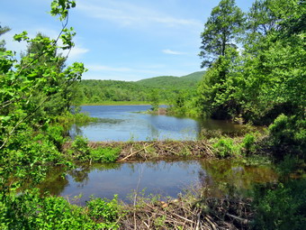 I noticed several large plastic culverts along the way. The DEC has started a project to replace the metal culverts and to install culverts were they were needed but did not exist. That project began at least six years ago but was not completed and the black culverts stand out like a sore thumb. The rest of the Loggers Loop to Iron Wheel Junction usually has deep ponds and large mud pits but on this day there were no ponds and only few small muddy areas. We came to a large culvert that directs a substantial stream underneath the trail. I stopped to take some shots as the stream was completely dry! We continued on the trail and it wasn't long before we were walking downhill and the climbing a small hill to Iron Wheel Junction. We stopped at the trail junction so I could take some pictures of the wheels that give the junction its name. Sheena posed for some pictures before we turned left and headed back toward Frick Pond on the Quick Lake Trail. The trail is slightly downhill which allowed us to keep up a good pace. It was made even easier as the places that are normally wet and muddy were almost dry! When we came to the small stream in the woods, we found the water level so low it was hard to see any water flowing. I took some pictures of the area before we move on. Walking through the "spruce tunnel" was easy as it too was almost dry. Eventually we walked out the other side where the trail was mostly dry with a little mud. We came to another big blowdown that had been cleared. We continued on the trail and arrived at the junction with the Big Rock Trail where we turned right to stay on the Quick Lake Trail. We headed toward the bridge at the outlet end of Frick Pond. The trail was dry with hardly any mud. We continued on the Quick Lake Trail to the bridge across the outlet of Frick Pond. We crossed the bridge and stopped at the other side. I dropped my pack to get out the camera despite the fact that I have taken hundreds of pictures from this location. The skies were blue with only a few clouds. I also took shots of the pond and of Beech Mountain. The main beaver dam had been built up and most of the gaps had been plugged. This had raised the water level significantly and the beavers were building a lodge just north of the dam on the east side of the pond. Sheena posed on the ridge and I took a few pictures. I packed up and we continued up the hill and back to Gravestone Junction. This section of trail was a little damp with some mud. At Gravestone Junction we continued out the Quick Lake Trail and back to the car. We arrived at the car at 1:05 PM having hiked 3.7 miles in 1 hours and 55 minutes with an elevation gain of 340 feet. Our time stopped was 5 minutes most of which was time spent taking pictures. Our overall speed was 2 MPH while our moving speed was 2.1 MPH. The temperature was 82 degrees and the sun was shining brightly. The car from the smaller lot was gone but another care was parked in the bigger lot. As I drove down Beech Mountain Road, I thought about stopping at Mongaup falls. When we reached Mongaup Road, I noticed a car parked in the small pull off and two parked on the side of the road. I didn't want the company so I continued toward home.
![]()
![]()
![]()
![]()
![]() On Wednesday, June 3rd, I had coverage for ambulance calls from 8:30 AM to 2:30 PM and really wanted to go for a longer hike. The weather forecast was for temperatures in the high 70s and blue skies. I asked Cindy if she wanted to go and she agreed to hike on the Parksville Rail Trail. Both of us had a spring cold and thought this was the best compromise. A quick walk on the rail trail was better than none and we knew Sheena would agree. We began to get ready at 11:30 AM with Sheena keeping a close eye on us both. Sheena knows exactly what the words "Hike" or "walk" mean. She also sniffs our clothing to confirm. The temperature was 78 degrees on the back porch with blue skies and plenty of sunshine. The Parksville Rail Trail is under three miles out and back but keeping a quick pace helps increase the difficulty as does wearing a pack. Sheena actually does get in about twice the mileage that I do as she forges ahead and then comes back! I have transitioned from using a leash all the time to using a GarmimSport PRO electronic collar which has many versatile settings and seems to do the job. This allows Sheena to roam and keeps me sane by not having to yank on her leash. It seems that Sheena likes hiking as she smells my clothes and then runs to sit by the door or wanders around my study watching me get dressed! On this day she could hardly contain herself! I got dressed in my Columbia OmniShade top without a baselayer. I put on a pair of RailRiders hiking pants which are expensive but last along time and have features like deep pockets and a generous cut which I really like. These pants do not have Velcro closures at the ankles to discourage sticks and gravel from getting into my shoes and to combat ticks. I decided to put on my Keen Durand hiking boots which fit well. I added a new pair of Xstance insoles in an effort to find the best support and cushioning for my feet. These insoles have shock absorbing gel pads, TPU arch support, and memory foam cushioning all wrapped in a breathable fabric. The insoles have been hyped by their manufacturer and seemed to be living up to their claims. I put on my OR BugOut gaiters to block the ticks and fend off the mud I expected to find. I grabbed a pair of Leki Makalu Lite poles as I had recently replaced the tips and because they lock without slipping.
On Wednesday, June 3rd, I had coverage for ambulance calls from 8:30 AM to 2:30 PM and really wanted to go for a longer hike. The weather forecast was for temperatures in the high 70s and blue skies. I asked Cindy if she wanted to go and she agreed to hike on the Parksville Rail Trail. Both of us had a spring cold and thought this was the best compromise. A quick walk on the rail trail was better than none and we knew Sheena would agree. We began to get ready at 11:30 AM with Sheena keeping a close eye on us both. Sheena knows exactly what the words "Hike" or "walk" mean. She also sniffs our clothing to confirm. The temperature was 78 degrees on the back porch with blue skies and plenty of sunshine. The Parksville Rail Trail is under three miles out and back but keeping a quick pace helps increase the difficulty as does wearing a pack. Sheena actually does get in about twice the mileage that I do as she forges ahead and then comes back! I have transitioned from using a leash all the time to using a GarmimSport PRO electronic collar which has many versatile settings and seems to do the job. This allows Sheena to roam and keeps me sane by not having to yank on her leash. It seems that Sheena likes hiking as she smells my clothes and then runs to sit by the door or wanders around my study watching me get dressed! On this day she could hardly contain herself! I got dressed in my Columbia OmniShade top without a baselayer. I put on a pair of RailRiders hiking pants which are expensive but last along time and have features like deep pockets and a generous cut which I really like. These pants do not have Velcro closures at the ankles to discourage sticks and gravel from getting into my shoes and to combat ticks. I decided to put on my Keen Durand hiking boots which fit well. I added a new pair of Xstance insoles in an effort to find the best support and cushioning for my feet. These insoles have shock absorbing gel pads, TPU arch support, and memory foam cushioning all wrapped in a breathable fabric. The insoles have been hyped by their manufacturer and seemed to be living up to their claims. I put on my OR BugOut gaiters to block the ticks and fend off the mud I expected to find. I grabbed a pair of Leki Makalu Lite poles as I had recently replaced the tips and because they lock without slipping.
As we walked out to the car at 11:50 AM, it felt warmer than the thermometer indicated. I put our gear in the back of the car and Sheena in the back seat and drove out Old Route 17 toward Parksville. I turned left under the Quickway overpass onto Service Road. I drove toward Parksville and pulled into the parking area on the right side of the road just after Fox Mountain Rd. There was one car parked in the lot and the owner was dealing with a small dog. It turned out that she was putting the dog in the car and getting ready to leave! I waited for her to drive off and then opened the car door. Sheena jumped out and headed for the trailhead. We started on our hike at 12:00 PM with the temperature at 78 degrees. The trail was dry at the beginning but I wondered what it would look like in the shade of the trees. Off her leash Sheena runs ahead of us a certain distance and then maintains that distance by waiting or increasing her pace. We were soon under the cover of the trees where the temperature did seem a few degrees cooler. The usual spots had some standing water and mud but these areas were smaller than on previous hikes. Sheena was enjoying the freedom of the hike and the various game tracks she could find. The trail runs parallel to the Little Beaverkill and the new section of State Route 17. It follows the route of the O&W railroad and is very flat. Sheena was trying to set a quick pace but Cindy and I kept a more relaxed stride. We didn't mind Sheena running back and forth as long as she would listen and wait for us when necessary.
I noticed that the noise from the stream was more muted than it had been and the level of the water was lower. We passed the first bench and I took a peek but the leaves on the trees were blocking much of it. We continued our hike by walking over the wooden walkways and bridge. The large patch of mud after the bridge was also smaller. We came to the landslide that had brought down several trees that had been cut and cleared. This area also had some open water and some mud. We negotiated this area and continued toward the falls. As we approached the falls there was an increase in noise from the stream. The falls came into view and the water level was much lower only a week ago. I decided I wanted to take some new pictures of the falls and the stream. Sheena and I walked down the path to the streambed and I put down my pack to get out the camera. The sunlight was very bright on the falls. I took pictures of the falls and the rapids in front of the falls from different angles and zooms. I also took shots of the water level on the stone wall below the falls and some downstream. As I finished these pictures, Sheena hopped up on a rock and sat down with the falls in the background. I was a little surprised but took some shots. Sheena then sat in the water and I took some more pictures! I had her sit on another rock which is usually underwater and took a few more host. When we were done, I put the camera away and we worked our way back up to where Cindy was waiting on the main trail. I put my pack down on the picnic table and got out my camera. I took a few pictures of the falls from above and also some of the rapids above the falls. After a few minutes, we continued onward to the Parksville end of the trail with Sheena setting a good pace. The remainder of the walk to the other end of the trail went quickly. Sheena took the lead which she sometimes is reluctant to do as there are sometimes dogs at the end of the trail. The large dog across the stream that had been and barking loudly last time was not present. This is a beautiful working dog but I have not been able to place the breed. As we approached the end of the trail, it was quiet with no loud music playing and no dogs outside barking!
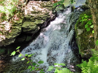 We tagged the end of the trail at 12:50 PM meaning it had taken us 50 minutes to hike one way. Sometimes it takes Sheena and I 27 minutes to cover the same distance! We turned around to head back to the car and the dogs began to bark from inside the house with the owner yelling at them. We walked quickly back toward the car with Sheena in the lead continuing to wander off trail. Sheena seemed fine and was out ahead of me at times and then rushing back to me before turning around. We passed by the falls and continued to push the pace. We soon came to the area of the mudslide and we picked our way aross and then continued our hike. We carefully walked over the slippery surface of the bridge and the walkways. As we approached the end of the trail, Sheena decided to let off some more energy by executing a set of zoomies. I eventually called her and told her "With" which is the equivalent of "Heel". As we broke out of the trees I could feel that the temperature had increased and the sun was out full force. We arrived back at the car at 1:25 PM after covering the return trip in 35 minutes as we had not stopped for any photography! We had hiked 2.7 miles in 1 hour and 25 minutes. The temperature in the car was 90 degrees but dropped to 82 degrees as we pulled away. I have been trying to avoid using commercial tick medications on Sheena as they are poison to the ticks but also can effect dogs. I have tried several all-natural products but so far they have not been as effective as I had hoped.
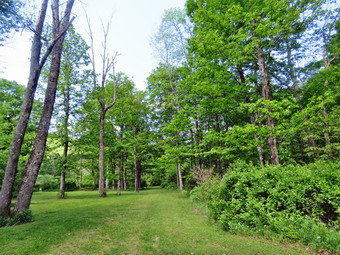
![]()
![]()
![]()
![]()
![]() On Tuesday, June 2nd, I planned to get in a longer hike after several days off fighting a cold. I had ambulance coverage from 08:30 AM to 2:30 PM but decided I would do a shorter hike so that Cindy could go. I got up at 6:30 AM after catching up on sleep with no overnight ambulance calls. The temperature was 64 degrees and there was plenty of fog. The forecast was for blue skies with some clouds amd temperatures in the 70s. I asked Cindy if she would like to hike along the Beaverkill at the campgrounds. She said "Yes" as her Bible study was canceled. We both had some things to take care of around the house so we did not begin to get dressed until 10:30 AM with the temperature at 73 degrees. We both wondered if there would be anyone camping at the Beaverkill Campgrounds since they had opened on Memorial Day weekend. As usual, Sheena was excited but was trying to be the "good dog". I got dressed in my Columbia OmniShade top without a baselayer. I put on a pair of RailRiders hiking pants which are expensive but last along time and have features like deep pockets and a generous cut which I really like. These pants do not have Velcro closures at the ankles to discourage sticks and gravel from getting into my shoes and to combat ticks. I decided to put on my Keen Durand hiking boots which fit well. I added a new pair of Xstance insoles in an effort to find the best support and cushioning for my feet. These insoles have shock absorbing gel pads, TPU arch support, and memory foam cushioning all wrapped in a breathable fabric. The insoles have been hyped by their manufacturer and seemed to be living up to their claims. I put on my OR BugOut gaiters to block the ticks and fend off the mud I expected to find. I grabbed a pair of Leki Micro Vario poles I have been using for some time because they are light and lock without slipping. I put our gear in the back of the car and Sheena in the back seat and left the house at 11:45 AM. I drove out Old Route 17 toward Roscoe and turned right on Beaverkill Road. As we started the descent into the Beaverkill Valley, I turned left on Campsite Road and followed it down to the parking area near the Beaverkill Covered Bridge. There were several cars parked in the lot with no one inside. There was a man preparing to go fly fishing and he was headed down to the stream just under the bridge. A glance at the river showed that the water level was actually much lower than I had expected.
On Tuesday, June 2nd, I planned to get in a longer hike after several days off fighting a cold. I had ambulance coverage from 08:30 AM to 2:30 PM but decided I would do a shorter hike so that Cindy could go. I got up at 6:30 AM after catching up on sleep with no overnight ambulance calls. The temperature was 64 degrees and there was plenty of fog. The forecast was for blue skies with some clouds amd temperatures in the 70s. I asked Cindy if she would like to hike along the Beaverkill at the campgrounds. She said "Yes" as her Bible study was canceled. We both had some things to take care of around the house so we did not begin to get dressed until 10:30 AM with the temperature at 73 degrees. We both wondered if there would be anyone camping at the Beaverkill Campgrounds since they had opened on Memorial Day weekend. As usual, Sheena was excited but was trying to be the "good dog". I got dressed in my Columbia OmniShade top without a baselayer. I put on a pair of RailRiders hiking pants which are expensive but last along time and have features like deep pockets and a generous cut which I really like. These pants do not have Velcro closures at the ankles to discourage sticks and gravel from getting into my shoes and to combat ticks. I decided to put on my Keen Durand hiking boots which fit well. I added a new pair of Xstance insoles in an effort to find the best support and cushioning for my feet. These insoles have shock absorbing gel pads, TPU arch support, and memory foam cushioning all wrapped in a breathable fabric. The insoles have been hyped by their manufacturer and seemed to be living up to their claims. I put on my OR BugOut gaiters to block the ticks and fend off the mud I expected to find. I grabbed a pair of Leki Micro Vario poles I have been using for some time because they are light and lock without slipping. I put our gear in the back of the car and Sheena in the back seat and left the house at 11:45 AM. I drove out Old Route 17 toward Roscoe and turned right on Beaverkill Road. As we started the descent into the Beaverkill Valley, I turned left on Campsite Road and followed it down to the parking area near the Beaverkill Covered Bridge. There were several cars parked in the lot with no one inside. There was a man preparing to go fly fishing and he was headed down to the stream just under the bridge. A glance at the river showed that the water level was actually much lower than I had expected.
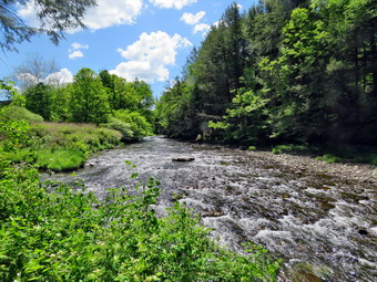 I let Sheena out of the car and put her on her leash. We started our hike at 11:05 AM by walking out of the parking lot to the bridge with the temperature at 72 degrees. When we got to the other side, the gate that blocks the road along the river and through the old campsites was missing. I looked at the trail and saw that it had no water or mud and that the grass was green and mowed. We turned left on a woods road that parallels the river and started down the short hill. At the bottom of the hill I let Sheena off her leash. I had decided to take some pictures on the way out. We passed the spring house on the right and the ditch that runs from the spring which had some water plants already growing. When we got to the first culvert, I noticed that the path down to the edge of the stream was eroded and very steep. I decided not to attempt to get down to the stream that way. I walked just passed this area and put down my pack and got out my camera. I took some pictures of the stream where the water was sparkling. When I was done, we continued our walk along the woods road which had short green grass. Sheena was running ahead of us back and forth following game trails and sniffing the air.
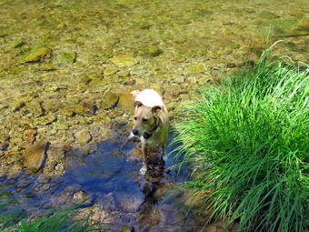 Along the way, some picnic tables blended into the landscape. The whole area had a haunted feeling enhanced by the sound of the flowing water. On the trail we passed by several areas with picnic tables. These tables sit unused and rotting along the road, a testimony to better days when this area had campsites. Now this area is used for day use only. We walked by more tables which had not been used in years. I stopped to take a few shots of the woods road and the picnic tables. Soon we came to what was once a bathroom for some campsites that had long since disappeared. There were more tables in this area. We stopped and I walked to the stream where rocks had been piled up and contained by wire screen. I walked to the edge and carefully stood on some rocks to take more pictures of the stream in both directions. The bright sunlight made taking the pictures difficult but then the sun went behind some clouds. Sheena came over and stood on the wall next to me. The rapids in this area were more turbulent and the sunlit sparkled. We continued on the woods road and at about .7 miles into the hike the woods road met the paved road that serves the campsites. We were surprised to see that there were campsites that were occupied! It was a beautiful day but we wondered who was camping during the week in the first week of June! I put Sheena on her leash and we continued on the road through the campsites and along the river. Many of the campsites have a cement block fireplace with a grill but some were upgraded to poured concrete. Despite the people camping everything was quiet except for the water in the river and one barking dog.
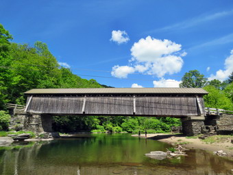 We walked along the paved road to a bathroom where we continued straight ahead to the last campsite. Where the road ends, Sheena and I walked down to the edge of the river. I was careful to watch where I was walking as the side of the stream was middy. Sheena immediately went wading and got a dirk from the stream. I took some pictures of Sheena in the water. I also got pictures of the stream from different locations, angles and zooms. I stopped to take some pictures of the river especially downstream. I walked back up to my pack and stowed the camera. We walked back on the campsite road toward the last bathroom where Cindy had decided to await for us. Where the road split, there had been a gathering of picnic tables which was now replaced with a camper. We stayed to the left to walk the parallel section of road back through the campsites. The road parallels the one we walked out on to make a sort of loop. We continued along the woods road to the maintenance building and stayed right to walk back on the woods road we had come out on. I let Sheena off her leash so she could have some more time to run around. We followed the road back to the bridge where I put Sheena on her leash .We climbed the small hill before walking through the bridge. We turned right to head back to the parking area. We went back to the car where Sheena and Cindy got in. I went down toward the river's edge but stopped to take some pictures of the bridge from the bank before descending the stairs. I walked down the steps to the stream and walked over to the large rock where I often take picture. The rock had been covered with water for the last few times I had been there but was now completely exposed. I took pictures downstream at different zooms and then took pictures of the bridge. I walked back to the car and stowed by camera. We had finished hiking at 12:20 PM after hiking over 2 miles in 1 hour and 5 minutes with at least 15 minutes of stopped time for pictures. The car's thermometer read 71 degrees and the skies were still blue and sunny.
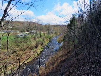
![]()
![]()
![]()
![]()
![]() On Thursday, May 28th, I had coverage for ambulance calls from 8:30 AM to 2:30 PM and really wanted to go for a longer hike to make three days in a row, The weather forecast was for overcast skies and showers leading to rain in afternoon starting around 2:00 PM. Unfortunately, we had a call at 3:00 AM and I did not get home until 5:30 AM> Often when I get home I am not able to immediately get to sleep which was the case this time. I fell asleep again at 7:00 AM and slept to 11:00 AM. I woke up relatively rested. I decided that a quick walk on the rail trail was better than none and I knew Sheena would agree. I began to get ready at 11:30 AM with Sheena keeping a close eye on me. Sheena knows exactly what the words "Hike" or "walk" mean. She also sniffs my clothing to confirm. The temperature was 68 degrees on the back porch with overcast skies and some sunshine. The Parksville Rail Trail is under three miles out and back but keeping a quick pace helps increase the difficulty as does wearing a pack. Sheena actually does get in about twice the mileage that I do as she forges ahead and then comes back! I have transitioned from using a leash all the time to using a GarmimSport PRO electronic collar which has many versatile settings and seems to do the job. This allows Sheena to roam and keeps me sane by not having to yank on her leash. It seems that Sheena likes hiking as she smells my clothes and then runs to sit by the door or wanders around my study watching me get dressed! On this day she could hardly contain herself! I got dressed in my Columbia OmniShade top without a baselayer. I put on a pair of RailRiders hiking pants which are expensive but last along time and have features like deep pockets and a generous cut which I really like. These pants do not have Velcro closures at the ankles to discourage sticks and gravel from getting into my shoes and to combat ticks. I decided to put on my Keen Durand hiking boots which fit well. I added a new pair of Xstance insoles in an effort to find the best support and cushioning for my feet. These insoles have shock absorbing gel pads, TPU arch support, and memory foam cushioning all wrapped in a breathable fabric. The insoles have been hyped by their manufacturer and seemed to be living up to their claims. I put on my OR BugOut gaiters to block the ticks and fend off the mud I expected to find. I grabbed a pair of Leki Micro Vario poles I have been using for some time because they are light and lock without slipping.
On Thursday, May 28th, I had coverage for ambulance calls from 8:30 AM to 2:30 PM and really wanted to go for a longer hike to make three days in a row, The weather forecast was for overcast skies and showers leading to rain in afternoon starting around 2:00 PM. Unfortunately, we had a call at 3:00 AM and I did not get home until 5:30 AM> Often when I get home I am not able to immediately get to sleep which was the case this time. I fell asleep again at 7:00 AM and slept to 11:00 AM. I woke up relatively rested. I decided that a quick walk on the rail trail was better than none and I knew Sheena would agree. I began to get ready at 11:30 AM with Sheena keeping a close eye on me. Sheena knows exactly what the words "Hike" or "walk" mean. She also sniffs my clothing to confirm. The temperature was 68 degrees on the back porch with overcast skies and some sunshine. The Parksville Rail Trail is under three miles out and back but keeping a quick pace helps increase the difficulty as does wearing a pack. Sheena actually does get in about twice the mileage that I do as she forges ahead and then comes back! I have transitioned from using a leash all the time to using a GarmimSport PRO electronic collar which has many versatile settings and seems to do the job. This allows Sheena to roam and keeps me sane by not having to yank on her leash. It seems that Sheena likes hiking as she smells my clothes and then runs to sit by the door or wanders around my study watching me get dressed! On this day she could hardly contain herself! I got dressed in my Columbia OmniShade top without a baselayer. I put on a pair of RailRiders hiking pants which are expensive but last along time and have features like deep pockets and a generous cut which I really like. These pants do not have Velcro closures at the ankles to discourage sticks and gravel from getting into my shoes and to combat ticks. I decided to put on my Keen Durand hiking boots which fit well. I added a new pair of Xstance insoles in an effort to find the best support and cushioning for my feet. These insoles have shock absorbing gel pads, TPU arch support, and memory foam cushioning all wrapped in a breathable fabric. The insoles have been hyped by their manufacturer and seemed to be living up to their claims. I put on my OR BugOut gaiters to block the ticks and fend off the mud I expected to find. I grabbed a pair of Leki Micro Vario poles I have been using for some time because they are light and lock without slipping.
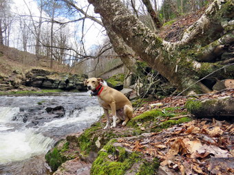 As we walked out to the car at 11:50 AM, it felt warmer than the thermometer indicated. I put my gear in the back of the car and Sheena in the back seat and drove out Old Route 17 toward Parksville. I turned left under the Quickway overpass onto Service Road. I drove toward Parksville and pulled into the parking area on the right side of the road just after Fox Mountain Rd. There were no cars parked in the lot which is just the way we like it. As I opened the car door Sheena jumped out amd headed for the trailhead. We started on our hike at 12:00 PM with the temperature at 68 degrees. The trail was only slightly damp at the beginning but I didn't have wondered what it would look like in the shade of the trees because we had hiked the trail two days ago. Off her leash Sheena runs ahead of me a certain distance and then maintains that distance by waiting or increasing her pace. We were soon under the cover of the trees where the temperature did seem a few degrees cooler. The usual spots had some standing water and mud. These areas were wider and deeper than on our last hike because of the recent rain. Sheena was enjoying the freedom of the hike and the various game tracks she could find. The trail runs parallel to the Little Beaverkill and the new section of State Route 17. It follows the route of the O&W railroad and is very flat. Sheena was setting a quick pace and I didn't mind as long as she would listen and wait for me when necessary. As walked a few drops of rain began to fall and I hoped it would no rain too hard as I wanted to complete the hike as planned.
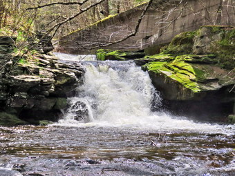 I noticed that the noise from the stream was a loud roar and several views showed the water was high and running rapidly. We passed the first bench and I took a peek but I knew that the leaves on the trees were blocking much of it. We continued our hike by walking over the wooden walkways and bridge. There was a large patch of mud after the bridge. We came to the landslide that had brought down several trees that had been cut and cleared. This area also had open water and a lot of mud. We negotiated this area and continued toward the falls. As we approached the falls there was a significant increase in noise from the stream. The falls came into view and the water level was high. We walked by the falls and the rapids upstream of the falls and I could see the water level was about as high as on our last trip. At this point I decided we would just hike for the exercise and I would forego the photography. This decision was based on the fact that the overcast was more uniform, rain was still falling, and I did not Wat to push my time limit. We continued onward to the Parksville end of the trail with Sheena setting a good pace. The remainder of the walk to the other end of the trail went quickly. Sheena took the lead which she sometimes is reluctant to do as there are sometimes dogs at the end of the trail. The large dog across the stream was back and barking loudly. This is a beautiful working dog but I could not place the breed. As we approached the end of the trail, it was quiet with no loud music playing and no dogs outside barking!
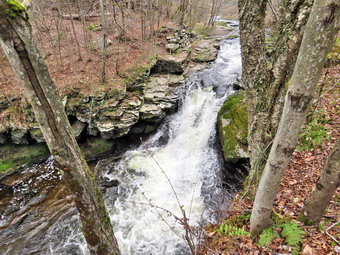 We tagged the end of the trail at 12:27 PM meaning it had taken us 27 minutes to hike one way which I counted as a victory given that this was three days in a row. We turned around to head back to the car. We walked quickly back toward the car with Sheena in the lead continuing to wander off trail. Sheena seemed fine and was out ahead of me at times and then rushing back to me before turning around. We passed by the falls and continued to push the pace. We soon came to the area of the mudslide and we picked our way aross and then continued our hike. We carefully walked over the slippery surface of the bridge and the walkways. As we approached the end of the trail, Sheena decided to let off some more energy by executing a set of zoomies. I eventually called her and told her "With" which is the equivalent of "Heel". As we broke out of the trees We could see couple with a dog starting out on the trail. I pulled Sheena off the trail as they passed and then continued to the car. We arrived back at the car at 12:52 PM after covering the return trip in 25 minutes! We had hiked 2.7 miles in 52 minutes! The air temperature had dropped to 64 degrees and the rain drops were falling.
![]()
![]()
![]()
![]()
![]() On Wednesday, May 27th I had ambulance coverage from 9:00 AM to 2L00 PM so I asked Cindy where she wanted to hike. She initially chose Dry Brook Ridge from Hill Road. I pointed out that hike was almost 6 miles with lots of uphill. This change here mind and she asked about the Shavertown Trails. I agreed that this was easier as it was only about miles but it still had some climbing. The Catskill Mountain Club created the trails in this area and added an additional trail in the fall with a lookout over the Tremperskill Valley. The weather forecast was for a bright and sunny day with high temperatures in the 70's. We started to get ready at 9:30 AA with the temperature at 82 degress on the back porch. Sheena lay quietly on my floor but her eyes watched every movement I made. I got dressed in my Columbia OmniShade top without a baselayer. I put on a pair of RailRiders hiking pants which are expensive but last along time and have features like deep pockets and a generous cut which I really like. These pants do not have Velcro closures at the ankles to discourage sticks and gravel from getting into my shoes and to combat ticks. I decided to put on my Keen Durand hiking boots which fit well. I added a new pair of Xstance insoles in an effort to find the best support and cushioning for my feet. These insoles have shock absorbing gel pads, TPU arch support, and memory foam cushioning all wrapped in a breathable fabric. The insoles have been hyped by their manufacturer and seemed to be living up to their claims. I put on my OR BugOut gaiters to block the ticks and fend off the mud I expected to find. I grabbed a pair of Leki Micro Vario poles I have been using for some time because they are light and lock without slipping. My final choice was a floppy OR hat for shade and as a base for insect repellent if needed. I put our gear in the back of the car and Sheena in the backseat and left Livingston Manor at 10:15 AM. I headed north on the Quickway and got off at exit 94 for Roscoe. I drove through Roscoe and across the Rockland Flats on Route 206. I continued on Route 206 to the Pepacton Reservoir. At the Pepacton, I turned right on Route 30 to drive toward the bridge across the reservoir. After 12 miles, I turned left onto the bridge. At the other end of the bridge, I turned left and left again into the parking area. The lot was almost filled with DEP Police vehicles. I thought this odd as the lot is meant for hikers. I found one empty space next to another car and parked. I was prepared to hike .2 miles further on the road to get to the trailhead but noticed there was a sign for the trails just across the road! The CMC had created this trailhead so that people would not park along side the road at the old trailhead and would not have to walk along the road from the new parking area. I set my GPS and we headed across the road at 10:50 AM to start our hike with the temperature at 78 degrees.
On Wednesday, May 27th I had ambulance coverage from 9:00 AM to 2L00 PM so I asked Cindy where she wanted to hike. She initially chose Dry Brook Ridge from Hill Road. I pointed out that hike was almost 6 miles with lots of uphill. This change here mind and she asked about the Shavertown Trails. I agreed that this was easier as it was only about miles but it still had some climbing. The Catskill Mountain Club created the trails in this area and added an additional trail in the fall with a lookout over the Tremperskill Valley. The weather forecast was for a bright and sunny day with high temperatures in the 70's. We started to get ready at 9:30 AA with the temperature at 82 degress on the back porch. Sheena lay quietly on my floor but her eyes watched every movement I made. I got dressed in my Columbia OmniShade top without a baselayer. I put on a pair of RailRiders hiking pants which are expensive but last along time and have features like deep pockets and a generous cut which I really like. These pants do not have Velcro closures at the ankles to discourage sticks and gravel from getting into my shoes and to combat ticks. I decided to put on my Keen Durand hiking boots which fit well. I added a new pair of Xstance insoles in an effort to find the best support and cushioning for my feet. These insoles have shock absorbing gel pads, TPU arch support, and memory foam cushioning all wrapped in a breathable fabric. The insoles have been hyped by their manufacturer and seemed to be living up to their claims. I put on my OR BugOut gaiters to block the ticks and fend off the mud I expected to find. I grabbed a pair of Leki Micro Vario poles I have been using for some time because they are light and lock without slipping. My final choice was a floppy OR hat for shade and as a base for insect repellent if needed. I put our gear in the back of the car and Sheena in the backseat and left Livingston Manor at 10:15 AM. I headed north on the Quickway and got off at exit 94 for Roscoe. I drove through Roscoe and across the Rockland Flats on Route 206. I continued on Route 206 to the Pepacton Reservoir. At the Pepacton, I turned right on Route 30 to drive toward the bridge across the reservoir. After 12 miles, I turned left onto the bridge. At the other end of the bridge, I turned left and left again into the parking area. The lot was almost filled with DEP Police vehicles. I thought this odd as the lot is meant for hikers. I found one empty space next to another car and parked. I was prepared to hike .2 miles further on the road to get to the trailhead but noticed there was a sign for the trails just across the road! The CMC had created this trailhead so that people would not park along side the road at the old trailhead and would not have to walk along the road from the new parking area. I set my GPS and we headed across the road at 10:50 AM to start our hike with the temperature at 78 degrees.
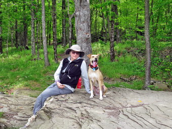 My first reaction was that the trail looked very much "used" meaning people had been using it. The trail was mostly dirt with a few rocks and roots here and there. There was some mud in spots and two or three small streams crossing the trail. It wasn't long before we were on the trail that had started at the old trailhead. In .25 miles the trail gains 220 feet at a 16% grade which is a good way to get started. On the way up the trail we met 4 hikers with two dogs coming down the trail. I went off trail with with Sheena and asked her to sit while I held her collar as the hikers passed by. This section of trail ends on a road and there is a set of signs just across the road that direct hikers. We chose to cross the road and head toward the "Overlook". The trail we were on now was one that Cindy and I had helped create when the DEP closed the road that was being used to get to Snake Pond because of a logging project. This part of the trail was also worn in and was covered in pine needles and leaves. The stream that crossed the trail was as high as I have seen it but proved to be no obstacle. After .1 miles or .5 miles into the hike, we came to a sign that indicated that the new trail continued straight ahead to the overlook. The trail to the pond turned to the right. We continued straight ahead and started heading north gaining a little elevation as we continued along the trail. The trail was a little more worn in than when we had first hiked it and there were a few muddy spots along the way. At .7 miles the trail began to gain elevation more seriously. At times the trail followed old woods roads but only briefly. Sheena alerted to some voices coming from ahead of us on the trail. When I saw hikers coming down the trail. I went off the trail with Sheena and had her sit as I held her collar. It turned out that the "hikers" were DEP police officers with two K-9s! Cindy and I greeted the group as they passed. They said they were out on a training drill. Over the next half mile we continued to travel north gaining 350 feet. This is an average 14% grade but the last ascent is 26%. It was very warm and I was tired from a longer hike yesterday. Just after the last ascent the trail turned west and descended slightly to a large rock shelf that serves as the overlook. The overlook gives a nice view of the Pepacton to the southwest and the Tremperskill Valley to the northwest. Like many viewpoints this one was becoming narrower as the trees grow. I dropped my pack and took out the camera. I took quite a few pictures of the scenery and some of Cindy and Sheena sitting on the rock. Sheena also posed for some solo pictures. Cindy and I both got a drink and ate a bar as it was noon. We walked back out the trail to where there were some impressive rock formations. We continued back down the trail retracing the route we took on the way out. Going downhill was much easier than the climb on the way out. The return trip went quickly as we only had the few muddy spots to slow us down.
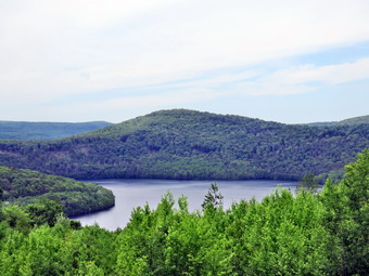 When we arrived back at the trail to the pond, we turned left and began to climb a little more. We were both a little tired of climbing so we slowed down and started to talk a little mpre. The hike up to the pond was only .2 miles but we did gain another 155 feet. We emerged just below the pond but continued up to the bench on the edge of the pond. I put my pack down and took out my camera. I snapped some shots of the reservoir and the pond. I also took pictures of Sheena ad Cindy sitting on the bench. I put my camera back in the pack and Sheena and I started walking clockwise around the pond. Cindy sat on the bench to get some extra rest. I stopped in several spots to take pictures. As we walked around the back of the pond, I noticed that the earthen bank that contained the water in the pond had been rebuilt. This meant that the trail around the back of the pond was in much better shape. I took some more pictures of the inlet and outlet of the pond which, strangely, are within a few feet of each other. I took some shots of tampon and the mountains in the background. We hiked up the road to the top of the hill above the pond and I took some more pictures while we waited for Cindy. We started to walk back to the car on a road was paved with large crushed stones. Within a short distance the road opened up into a large field. A little further down the road, there was a weather station and other meteorology equipment in the field. We continued our walk down the road entering the trees. At 2.65 miles we turned left on the trail which was well-marked with a large sign. The weather was still nice with plenty of sun and a slight breeze blowing. The trip down the trail was much quicker than the trip up. When we reached the road we cross and were back at the car. It was 1:23 PM and we had hiked 3.1 miles in 2 hours and 30 minutes with 28 minutes of stopped time. The elevation gain was 890 feet. The temperature in the car was 90 degrees but on our way home OT leveled out at 84 degrees.
![]()
![]()
![]()
![]()
![]() On Tuesday, May 26th, I had coverage for ambulance calls from 8:30 AM to 2:30 PM and really wanted to go for a longer hike as the weather forecast was for blue skies and bright sunshine. I was trying to get some sleep after several days of back to back ambulance calls. I decided to sleep in and eventually got up at 10:00 AM after numerous attempts by various people to prevent me from getting some rest! I did some chores around the house includinga much needed trip to the transfer station. I finally began to get ready at 11:45 AM with Sheena keeping a close eye on me. Sheena knows exactly what the words "Hike" or "walk" mean. She also sniffs my clothing to conform. I decided that we would go to hike the Parksville Rail Trail as it is close to home and has a nice waterfall. I was a little concerned that it was a beautiful day and part of an extended weekend and other people might have the same idea. The temperature was 78 degrees on the back porch with bright blue skies and plenty of sunshine. The Parksville Rail Trail is under three miles out and back but keeping a quick pace helps increase the difficulty as does wearing a pack. Sheena actually does get in about twice the mileage that I do as she forges ahead and then comes back! I have transitioned from using a leash all the time to using a GarmimSport PRO electronic collar which has many versatile settings and seems to do the job. This allows Sheena to roam and keeps me sane by not having to yank on her leash. It seems that Sheena likes hiking as she smells my clothes and then runs to sit by the door or wanders around my study watching me get dressed! On this day she could hardly contain herself! I got dressed in my Columbia OmniShade top without a baselayer. I put on a pair of RailRiders hiking pants which are expensive but last along time and have features like deep pockets and a generous cut which I really like. These pants do not have Velcro closures at the ankles to discourage sticks and gravel from getting into my shoes and to combat ticks. I decided to put on my Keen Durand hiking boots which fit well. I added a new pair of Xstance insoles in an effort to find the best support and cushioning for my feet. These insoles have shock absorbing gel pads, TPU arch support, and memory foam cushioning all wrapped in a breathable fabric. The insoles have been hyped by their manufacturer and seemed to be living up to their claims. I put on my OR BugOut gaiters to block the ticks and fend off the mud I expected to find. I grabbed a pair of Leki Micro Vario poles I have been using for some time because they are light and lock without slipping. My final choice was a floppy OR hat for shade and as a base for insect repellent if needed.
On Tuesday, May 26th, I had coverage for ambulance calls from 8:30 AM to 2:30 PM and really wanted to go for a longer hike as the weather forecast was for blue skies and bright sunshine. I was trying to get some sleep after several days of back to back ambulance calls. I decided to sleep in and eventually got up at 10:00 AM after numerous attempts by various people to prevent me from getting some rest! I did some chores around the house includinga much needed trip to the transfer station. I finally began to get ready at 11:45 AM with Sheena keeping a close eye on me. Sheena knows exactly what the words "Hike" or "walk" mean. She also sniffs my clothing to conform. I decided that we would go to hike the Parksville Rail Trail as it is close to home and has a nice waterfall. I was a little concerned that it was a beautiful day and part of an extended weekend and other people might have the same idea. The temperature was 78 degrees on the back porch with bright blue skies and plenty of sunshine. The Parksville Rail Trail is under three miles out and back but keeping a quick pace helps increase the difficulty as does wearing a pack. Sheena actually does get in about twice the mileage that I do as she forges ahead and then comes back! I have transitioned from using a leash all the time to using a GarmimSport PRO electronic collar which has many versatile settings and seems to do the job. This allows Sheena to roam and keeps me sane by not having to yank on her leash. It seems that Sheena likes hiking as she smells my clothes and then runs to sit by the door or wanders around my study watching me get dressed! On this day she could hardly contain herself! I got dressed in my Columbia OmniShade top without a baselayer. I put on a pair of RailRiders hiking pants which are expensive but last along time and have features like deep pockets and a generous cut which I really like. These pants do not have Velcro closures at the ankles to discourage sticks and gravel from getting into my shoes and to combat ticks. I decided to put on my Keen Durand hiking boots which fit well. I added a new pair of Xstance insoles in an effort to find the best support and cushioning for my feet. These insoles have shock absorbing gel pads, TPU arch support, and memory foam cushioning all wrapped in a breathable fabric. The insoles have been hyped by their manufacturer and seemed to be living up to their claims. I put on my OR BugOut gaiters to block the ticks and fend off the mud I expected to find. I grabbed a pair of Leki Micro Vario poles I have been using for some time because they are light and lock without slipping. My final choice was a floppy OR hat for shade and as a base for insect repellent if needed.
As we walked out to the car at 12:00 PM, it felt warmer than the thermometer indicated. I put my gear in the back of the car and Sheena in the back seat and drove out Old Route 17 toward Parksville. I turned left under the Quickway overpass onto Service Road. I drove toward Parksville and pulled into the parking area on the right side of the road just after Fox Mountain Rd. There was one car parked in the lot and I thought about hiking in the opposite direction toward Old Liberty Road. As I opened the car door Sheena jumped out amd headed for the trailhead. I set my GPS and we started on our hike at 12:13 PM with the temperature at 76 degrees. The trail was only slightly damp at the beginning but I wondered what it would look like in the shade of the trees because it had rained over the weekend. Off her leash Sheena runs ahead of me a certain distance and then maintains that distance by waiting or increasing her pace. We were soon under the cover of the trees where the temperature did seem at least 4 degrees cooler. The usual spots had some standing water and mud. These areas were wider and deeper than on our last hike because of the recent rain. Sheena was enjoying the freedom of the hike and the various game tracks she could find. I looked up to see a woman pushing a baby carriage with a dachshund on a leash. I called Sheena and took her to the side of the trail and asked her to sit. As the woman passed she said "Hello" but could no decide if Sheena was male or female! The trail runs parallel to the Little Beaverkill and the new section of State Route 17. It follows the route of the O&W railroad and is very flat. Sheena was setting a quick pace and I didn't mind as long as she would listen and wait for me when necessary. Again, I looked up and saw a solo male hiker headed toward us. He was using his cell phone and ignored me when I said "hello"> I wondered why someone would come out on a hike in such beautiful weather and ignore it for the phone! I assumed he was coming from Parksville and would turn around and come back so that we would see him again.
I noticed that the noise from the stream was a loud roar and several views showed the water was high and running rapidly. We came to the first bench and I walked over to the viewpoint over the stream. The view was not very different than always except that the leaves on the trees were blocking much of it. We continued our hike by walking over the wooden walkways and bridge. There was a large patch of mud after the bridge. We came to the landslide that had brought down several trees that had been cut and cleared. This area also had open water and a lot of mud. We negotiated this area and continued toward the falls. As we approached the falls there was a significant increase in noise from the stream. The falls came into view and the water level was high. I walked over to the falls and the rapids upstream of the falls and found the water high but not much higher than our last trip. I peeked at the falls and then we moved on. At this point I decided we would just hike for the exercise and I would forego the photography. I also was thinking about hiking the other half of the rail trail once we returned to the car. We continued onward to the Parksville end of the trail with Sheena setting a good pace. The remainder of the walk to the other end of the trail went quickly. Sheena took the lead which she sometimes is reluctant to do as there are sometimes dogs at the end of the trail. The large dog across the stream was absent. As we approached the end of the trail, it was quiet with no loud music playing and no dogs outside barking!
We tagged the end of the trail at 12:42 PM meaning it had taken us 29 minutes to hike one way which I counted as a victory given the number of people on the trail nad the trail conditions. We turned around to head back to the car. We walked quickly back toward the car with Sheena in the lead continuing to wander off trail. Sheena seemed fine and was out ahead of me at times and then rushing back to me before turning around. We passed by the falls and continued to push the pace. We soon came to the area of the mudslide and I saw a family of four approaching thatarea from the other side. We waited until they crossed and then continued our hike after picking our way across the mud. At one point I heard a crash behind me as a large branch fell onto the trail! I thought that this would have hurt someone if they were hit by it. We carefully walked over the slippery surface of the bridge and the walkways. As we approached the end of the trail, Sheena decided to let off some more energy by executing a set of zoomies. I eventually called her and told her "With" which is the equivalent of "Heel". We arrived back at the trailhead at 1:10 PM after covering the return trip in 28 minutes. We had hiked 2.7 miles in 57 minutes! I had the bright idea that we would turns around and hike the whole trail again. I knew there was enough time and that I was physically able. The challenge was mental! We turned around to begin the second iteration.
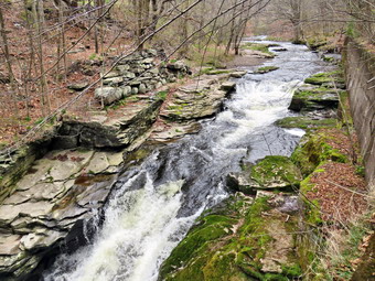 Since the objective was to finish the second trip on the trail as quickly as possible, we set a fast pace with me deep in my own thoughts and Sheena ranging ahead. We crossed the wooden walkways and the bridge to find the family of four headed toward us. We passed each other with a quick greeting and pushed on. We did not stop at the falls but continued toward the Parksville end of the trail. It did seem warmer and when I stepped out into the sun at the end of the trail I could definitely feel the temperature had increased. It was 1:38 PM which meant we had again covered the trail end-to-end in 28 minutes. We turned around and hurried back toward the falls. We passed the falls within 7 minutes and continued back toward the parking area. We have hiked this trail so many times now that every patch of mud or rocky strecth is familiar. We crossed the bridge and walkway. Just after this I saw a couple hiking toward us. Each had a single hiking staff. We exchanged greeting and continued in our opposite directions. When Sheena and I broke out into the sun, I noticed the warmth of the sun. We were back at the car at 2:07 PM having covered the second round trip in 57 minutes. All together we had hiked 5.5 miles in 1 hour and 54 minutes. Our moving and overall pace was 2.9 MPH which is very fast for us but the trail is almost flat. The GPS says about 200 feet in elevation gain but this is misleading. The temperature was 78 degrees.
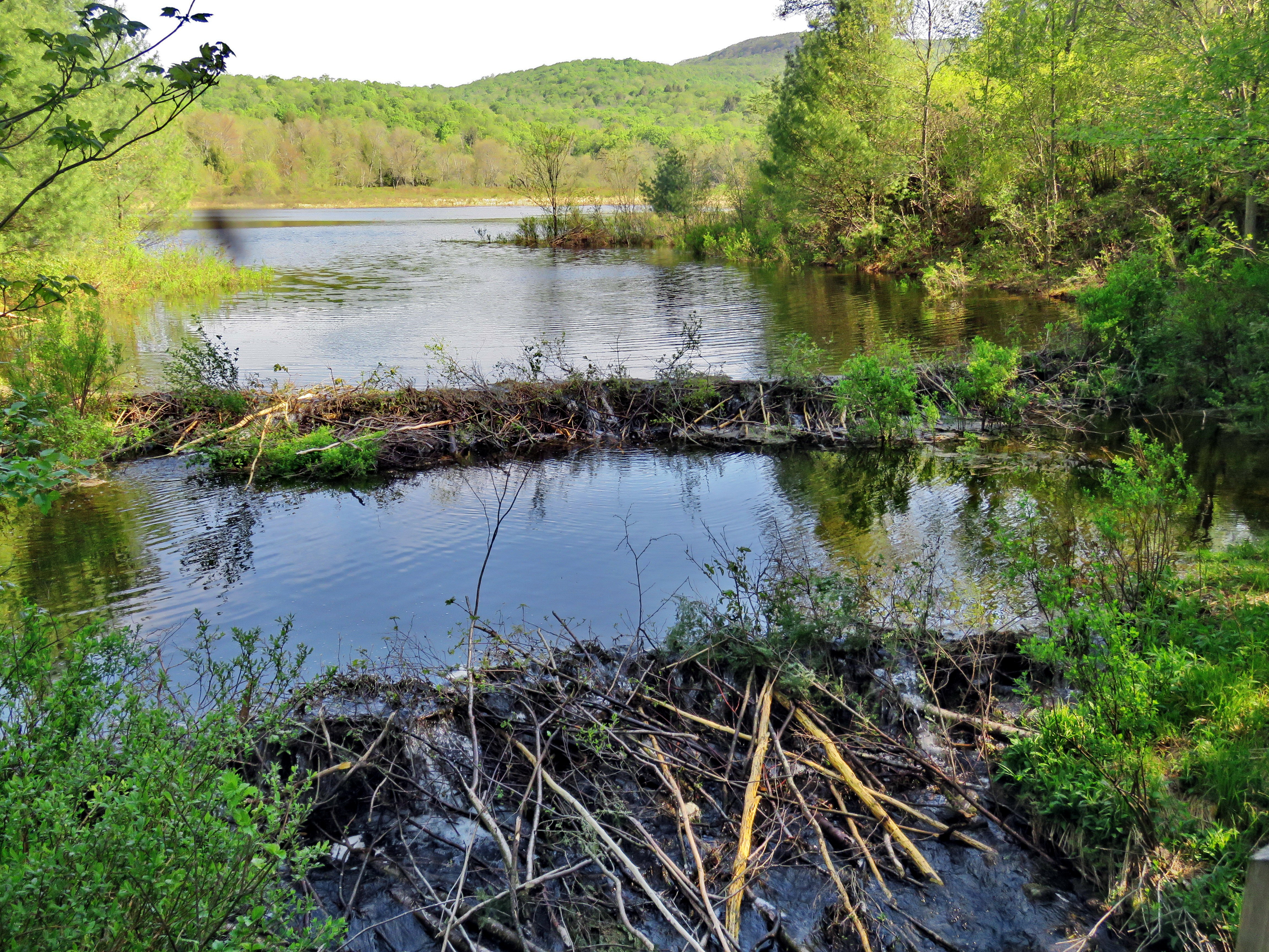
![]()
![]()
![]()
![]()
![]() On Tuesday, May 19th I planned to hike a longer route even though the temperature was forecast to be in the mid to high 80's! I had ambulance coverage from 8:30 AM to 2:30 PM and wanted to make the best of it. As often happens, we were paged for a mutual aid call to Empress in Parksville around 6:00 AM and for another mutual aid call for Empress immediately after. By the time I got home at 8:30 AM I was questioning how much energy I had to hike especially considering it was already 78 degrees on the back porch! I decided I would go to Frick and Hodge Ponds and try to hike around both ponds. This was ambitious given that I was not in the best shape and the weather look like it would be brutal. I began to get my gear together closely watched by Sheena who knew that we were going hiking. I got dressed in a Columbia Omni-shade long-sleeved crew top without a baselayer. I put on a pair of RailRiders hiking pants which are expensive but last along time and have features like deep pockets and a generous cut which I really like. These pants do not have Velcro closures at the ankles to discourage sticks and gravel from getting into my shoes and to combat ticks. I decided to put on my Keen Durand hiking boots which fit well. I added a new pair of Xstance insoles in an effort to find the best support and cushioning for my feet. These insoles have shock absorbing gel pads, TPU arch support, and memory foam cushioning all wrapped in a breathable fabric. The insoles have been hyped by their manufacturer and seemed to be living up to their claims. There was no eason to wear my Mammut hoody as the temperature certainly did not warrant it. I grabbed a pair of Leki Micro Vario poles I have been using for some time because they are light and lock without slipping. I put on my OR BugOut gaiters to block the ticks and fend off the mud I expected to find. I also decided to wear my wide-brimmed OR hat to shade me from the sun and to act as a place to spray some insect repellant. Imade sure I had a full water bottle and thought about a second. In the end I took only one! I put my gear in the car and Sheena in the back seat and left the house at 9:00 AM. I headed out the DeBruce Road and after six miles I turned left on Mongaup Road. Where the road split I stayed left on Beech Mountain Road and drove to the parking lots. There no cars in either lot as I pulled into the smaller lot to park. I got ready to get on the trail by setting my GPS to rack my route. I decided to start out doing the route I planned in a clockwise direction knowing I could bailout on the Loggers Loop if I had to do so.
On Tuesday, May 19th I planned to hike a longer route even though the temperature was forecast to be in the mid to high 80's! I had ambulance coverage from 8:30 AM to 2:30 PM and wanted to make the best of it. As often happens, we were paged for a mutual aid call to Empress in Parksville around 6:00 AM and for another mutual aid call for Empress immediately after. By the time I got home at 8:30 AM I was questioning how much energy I had to hike especially considering it was already 78 degrees on the back porch! I decided I would go to Frick and Hodge Ponds and try to hike around both ponds. This was ambitious given that I was not in the best shape and the weather look like it would be brutal. I began to get my gear together closely watched by Sheena who knew that we were going hiking. I got dressed in a Columbia Omni-shade long-sleeved crew top without a baselayer. I put on a pair of RailRiders hiking pants which are expensive but last along time and have features like deep pockets and a generous cut which I really like. These pants do not have Velcro closures at the ankles to discourage sticks and gravel from getting into my shoes and to combat ticks. I decided to put on my Keen Durand hiking boots which fit well. I added a new pair of Xstance insoles in an effort to find the best support and cushioning for my feet. These insoles have shock absorbing gel pads, TPU arch support, and memory foam cushioning all wrapped in a breathable fabric. The insoles have been hyped by their manufacturer and seemed to be living up to their claims. There was no eason to wear my Mammut hoody as the temperature certainly did not warrant it. I grabbed a pair of Leki Micro Vario poles I have been using for some time because they are light and lock without slipping. I put on my OR BugOut gaiters to block the ticks and fend off the mud I expected to find. I also decided to wear my wide-brimmed OR hat to shade me from the sun and to act as a place to spray some insect repellant. Imade sure I had a full water bottle and thought about a second. In the end I took only one! I put my gear in the car and Sheena in the back seat and left the house at 9:00 AM. I headed out the DeBruce Road and after six miles I turned left on Mongaup Road. Where the road split I stayed left on Beech Mountain Road and drove to the parking lots. There no cars in either lot as I pulled into the smaller lot to park. I got ready to get on the trail by setting my GPS to rack my route. I decided to start out doing the route I planned in a clockwise direction knowing I could bailout on the Loggers Loop if I had to do so.
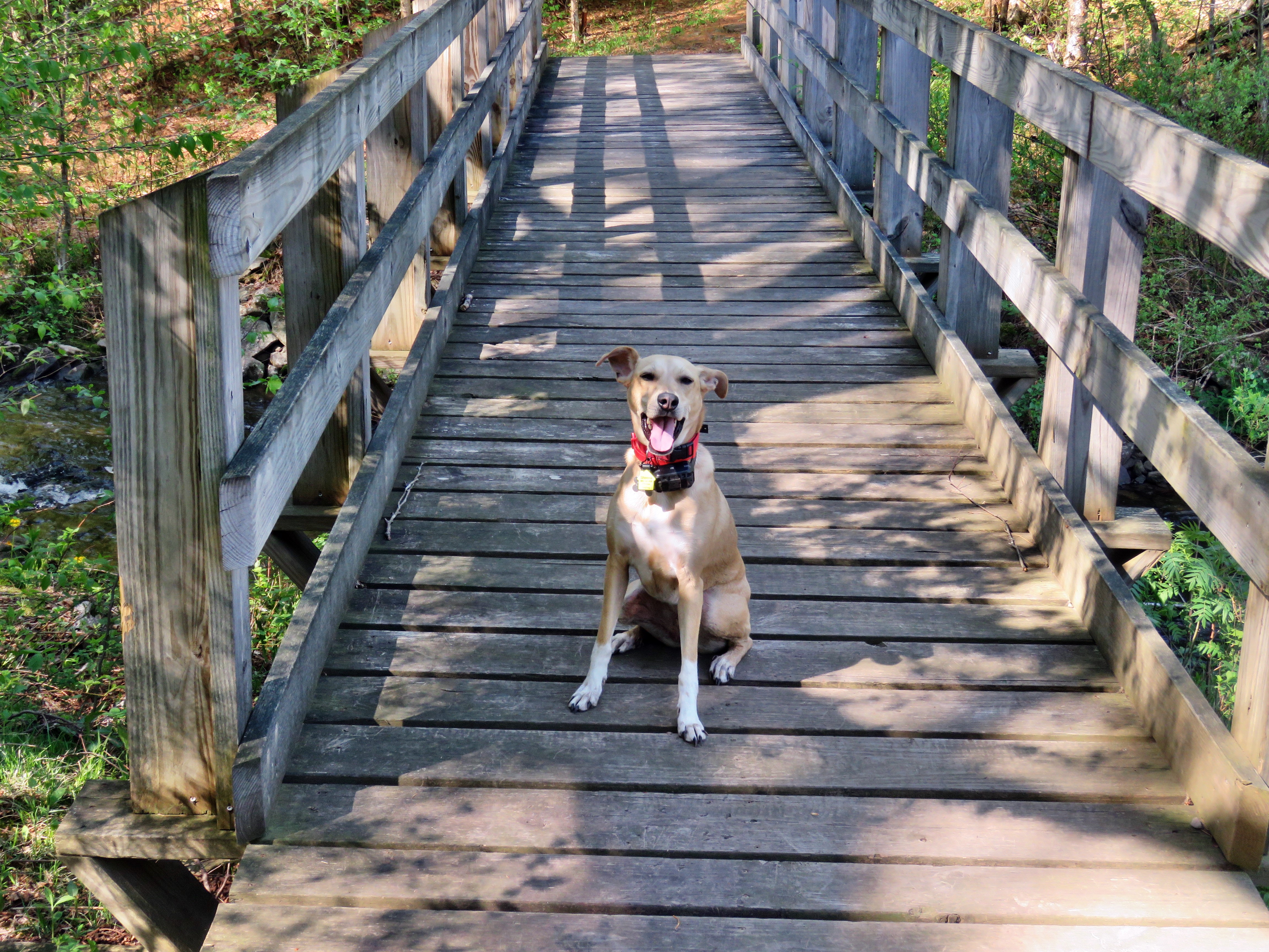 The temperature was 72 degrees and there was a slight breeze as we left the parking area at 9:25 AM. We headed out on the woods road that connects to the Quick Lake Trail at the register. The woods road after the register box was wet and muddy with some areas of standing water and several streams running across and down the trails. As we approached Gravestone Junction, I looked to the left at the memorial marker which was still in place. At Gravestone Junction I took note of the new sign which is still somewhat back from the trail but much more visible. We stayed to the left on the red Quick Lake Trail crossing the stepping stones the Willowemoc Trail Crew had installed. We walked down to the pond and I removed my pack to get out the camera. The skies were blue with some clouds and plenty of sun. The scene was much the same as always but I stopped to take a few pictures anyway. I took pictures of the pond and Flynn's Point. Frick Pond was much more of a pond now as the beavers had built a dam across the outlet stream from shore to shore. There was also a secondary dam below the main dam. I looked for a beaver lodge but did not see one but a knew one had to be present as the dam was all new. I picked up my pack and we crossed the bridge with Sheena madly dashing back and forth on the trail. We walked on the trail along the west side of the pond where there was more mud and water. At the trail junction with the Big Rock Trail, we headed left to stay on the Quick Lake Trail. We were keeping a pretty fast pace as we headed for Iron Wheel Junction. Sheena was running around following game trails and chasing a few chipmunks and squirrels. Several blowdowns had been cleared from the trail which was drier than I had seen it. We passed through the "spruce tunnel" which was wet and muddy and came to the small stream through the forest. The water was high but Sheena simply jumped across and I used some stepping stones to cross. I crossed without problems and Sheena crossed back and forth several times. We walked on the trail which continued to be wet and muddy but easy to navigate. I was feeling tired and very hot so I was considering cutting the hike short by taking the Loggers Loop back to the parking area making a 4 mile hike. We soon arrived at Iron Wheel Junction and I decided to turn left and continue on the Quick Lake Trail. We turned left to head toward Hodge Pond staying on the Quick Lake Trail. I tried to keep a quick pace up the hilly part of the trail but I was tired a thirsty. I stopped to get a drink which made me feel better. The trail was washed out in several places by past and recent rains. The trail was wet and muddy but we were able to work our way around the worst spots. We continued on the trail until it leveled off and descended slightly to Junkyard Junction at 3.1 miles. We turned right at this intersection and headed across the Flynn Trail toward Hodge Pond. The Flynn Trail was mostly wet and muddy along the entire length but was in better shape than often. The trip across this part of the Flynn Trail went relatively quickly and I was in better shape as I knew that the rest of the trip was downhill.
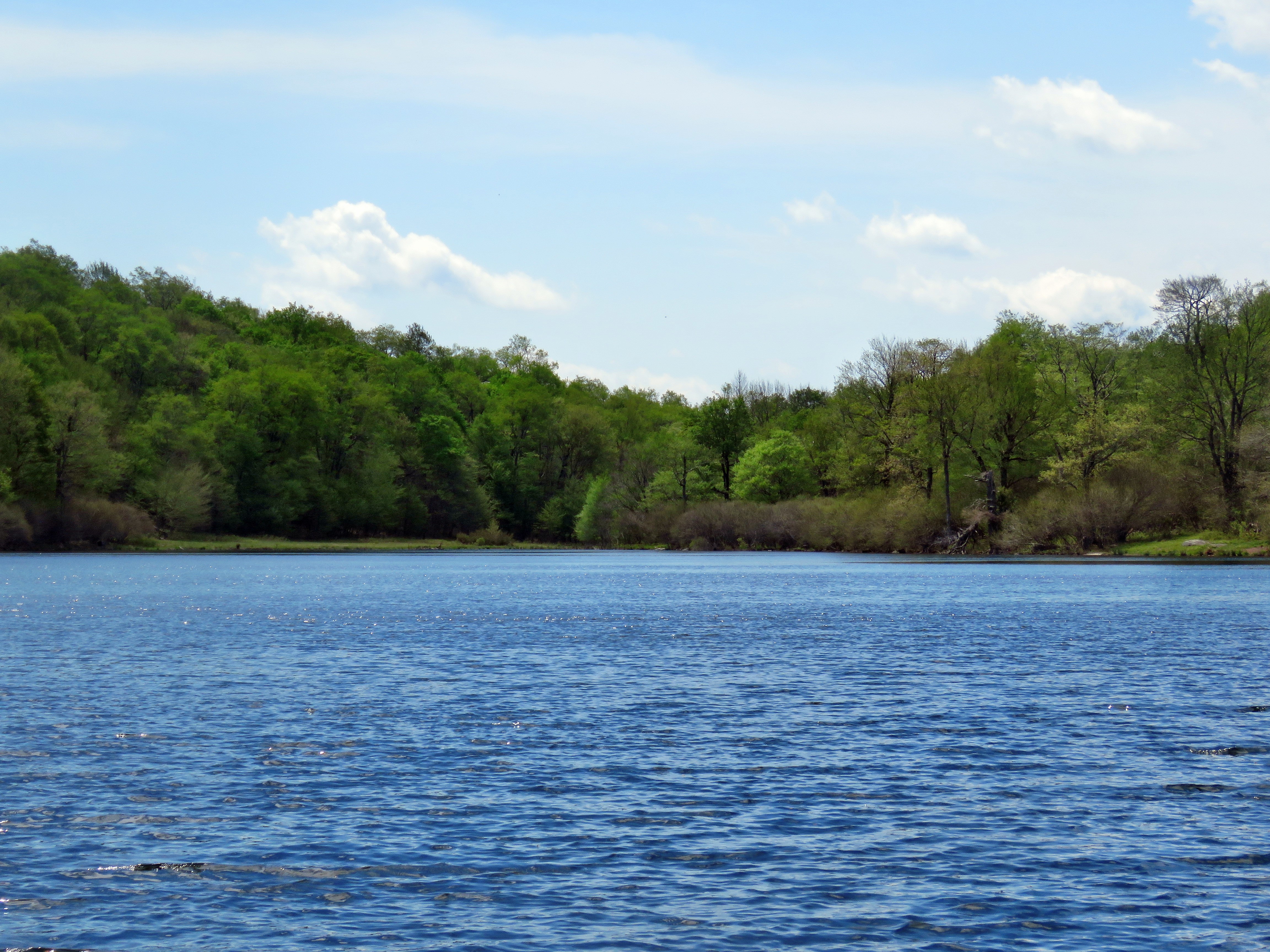 Soon we were at the gate where the trail turns right and heads down toward Hodge Pond. We reached the area near the shore of the pond and turned left to take the jeep trail around the back of the pond. I did this as I had not used this route recently and because I knew the Flynn Trail was blocked by a beaver dam at the outlet end of Hodge Pond. The sky was still blue with some clouds and the sun was shining brightly. When we came to a spot where there was view of the pond, we walked to the shore. Sheena got a quick drink and I took a few shots of the pond. We walked back up to the main trail and turned right to continue on the jeep trail. We came to a junction with a path that runs down to the outlet end of Hodge Pond. I chose to turn left and walk up the hill to avoid descending to the Hodge Pond outlet. This would require an ascent on the Flynn Trail from that area to the top of the hill. The climb up the hill was short but steep. When we reached the woods road at the top of the hill, we turned right and hiked the short distance to the Flynn Trail. We turned left at that point and walked the flat part of the Flynn Trail to the junction with the Big Rock Trail. This walk went quickly and I was feeling better as I knew that the walk down the Flynn Trail was downhill or flat. We had about 1.7 miles to go to get back to the car. This stretch can often seem long and boring but on this day it seemed to go rather quickly. The temperature had certainly increased and I finished the last of my water. Sheena was able to get some water from the ditch alongside the trail. We followed the Flynn Trail to the gate and then turned left to continue on the trail to avoid the private property around the cabin. We followed the trail through the woods and back to the car. As we were approaching the road, we could hear people in the woods to the left of the trail. I had no idea what they were doing as there are no trails in that area of the forest. Before going to the car, I inspected the new map at the kiosk and found it to be a great improvement over what had been posted. There were now three vehicles parked in the larger lot. We arrived back at 12:45 PM after hiking 6.5 miles in 3 hours and 20 minutes with 890 feet of elevation gain. We stopped for only 8 minutes and our moving average speed was 2.0 mph.
![]()
![]()
![]()
![]()
![]() On Saturday, May 16th, I was on call for ambulance calls but really wanted to go for a hike as the weather forecast was for blue skies and bright sunshine. I arranged ambulance coverage between 11:00 AM and 1:00 PM. I thought I would hike the Parksville Rail Trail as it is close to home and has a nice waterfall. I was a little concerned that it was a beautiful weekend day and other people might have the same idea. Unfortunately, an ambulance call came in at 9:20 AM. We were done with the call and I was home by 11:00 AM. I asked Cindy if she would like to go and she said "Yes" so we strated to get ready at 11:15 AM with the temperature at 72 degrees on the back porch with bright blue skies and plenty of sunshine. The Parksville Rail Trail is under three miles out and back but keeping a quick pace helps increase the difficulty. Sheena actually does get in about twice the mileage that I do as she forges ahead and then comes back! I have transitioned from using a leash all the time to using a GarmimSport PRO electronic collar which has many versatile settings and seems to do the job. This allows Sheena to roam and keeps me sane by not having to yank on her leash. It seems that Sheena likes hiking as she smells my clothes and then runs to sit by the door or wanders around my study watching me get dressed! On this day she could hardly contain herself! I got dressed in my Mammut crew top without a baselayer. I put on a pair of RailRiders hiking pants which are expensive but last along time and have features like deep pockets and a generous cut which I really like. These pants do not have Velcro closures at the ankles to discourage sticks and gravel from getting into my shoes and to combat ticks. I decided to put on my Keen Durand hiking boots which fit well. I added a new pair of Xstance insoles in an effort to find the best support and cushioning for my feet. These insoles have shock absorbing gel pads, TPU arch support, and memory foam cushioning all wrapped in a breathable fabric. The insoles have been hyped by their manufacturer and seemed to be living up to their claims. I decided not to wear my Mammut hoody as I would be was warm enough without it. I put on my OR BugOut gaiters to block the ticks and fend off the mud I expected to find. I grabbed a pair of Leki Micro Vario poles I have been using for some time because they are light and lock without slipping.
On Saturday, May 16th, I was on call for ambulance calls but really wanted to go for a hike as the weather forecast was for blue skies and bright sunshine. I arranged ambulance coverage between 11:00 AM and 1:00 PM. I thought I would hike the Parksville Rail Trail as it is close to home and has a nice waterfall. I was a little concerned that it was a beautiful weekend day and other people might have the same idea. Unfortunately, an ambulance call came in at 9:20 AM. We were done with the call and I was home by 11:00 AM. I asked Cindy if she would like to go and she said "Yes" so we strated to get ready at 11:15 AM with the temperature at 72 degrees on the back porch with bright blue skies and plenty of sunshine. The Parksville Rail Trail is under three miles out and back but keeping a quick pace helps increase the difficulty. Sheena actually does get in about twice the mileage that I do as she forges ahead and then comes back! I have transitioned from using a leash all the time to using a GarmimSport PRO electronic collar which has many versatile settings and seems to do the job. This allows Sheena to roam and keeps me sane by not having to yank on her leash. It seems that Sheena likes hiking as she smells my clothes and then runs to sit by the door or wanders around my study watching me get dressed! On this day she could hardly contain herself! I got dressed in my Mammut crew top without a baselayer. I put on a pair of RailRiders hiking pants which are expensive but last along time and have features like deep pockets and a generous cut which I really like. These pants do not have Velcro closures at the ankles to discourage sticks and gravel from getting into my shoes and to combat ticks. I decided to put on my Keen Durand hiking boots which fit well. I added a new pair of Xstance insoles in an effort to find the best support and cushioning for my feet. These insoles have shock absorbing gel pads, TPU arch support, and memory foam cushioning all wrapped in a breathable fabric. The insoles have been hyped by their manufacturer and seemed to be living up to their claims. I decided not to wear my Mammut hoody as I would be was warm enough without it. I put on my OR BugOut gaiters to block the ticks and fend off the mud I expected to find. I grabbed a pair of Leki Micro Vario poles I have been using for some time because they are light and lock without slipping.
As we walked out to the car at 11:30 PM, it felt warmer than the thermometer indicated. I put our gear in the back of the car and Sheena in the back seat and drove out Old Route 17 toward Parksville. I turned left under the Quickway overpass onto Service Road. I drove toward Parksville and pulled into the parking area on the right side of the road just after Fox Mountain Rd. There were several cars parked in the lot and I thought it would be a good idea to hike in the opposite direction toward Old Liberty Road. This way we could avoid the other hikers and allow Sheena to run free. Some people came walking on the trail toward the parking lot so Cindy thought we would be okay to hike toward Parksville. Against my better judgment I acquiest! As I opened the car door I told Sheena to "Stay". I put Sheena on her leash and locked the car. We started on our hike at 11:42 AM with the temperature at 72 degrees. The trail was only slightly damp at the beginning but I wondered what it would look like in the shade of the trees. Sheena behaved very nicely on her leash and after passing the oncoming hikers I let her off her leash. Off her leash Sheena runs ahead of us a certain distance and then maintains that distance by waiting or increasing her pace. We were soon under the cover of the trees where the temperature did cooler. The usual spots had some standing water and mud. These areas were wider and deeper than on our last hike as it ahd rained the night before. Sheena was enjoying the freedom of the hike and the various game tracks she could find. I was happy I had not worn the Mammut hoody as I was warm without the jecket. The trail runs parallel to the Little Beaverkill and the new section of State Route 17. It follows the route of the O&W railroad and is very flat. Sheena was setting a quick pace and I didn't mind as long as she would listen and wait for me when necessary. The mud pits had opened up and there was standing water on parts of the trail. This continued for much of the hike. I looked up to see two women coming toward us with their dogs on leashes so I put Sheena on her leash. One of the dogs wanted to play but Sheena just wanted to continue the hike.
I noticed that the noise from the stream was a loud roar and several views showed the water was high and running rapidly. As we approached the viewpoint just before the wooden walkways, I could see two women sitting on the bench. In addition, other hikers were approaching from behind! I put Sheena on her leash and wondered why I had agreed to hike in this direction! We passed the bench and walked over the wooden walkways and bridge where I let Sheena off her leash. I had decided to just hike and refrain from taking pictures as there were too many others on the trail. There was a large patch of mud after the bridge. We came to the landslide that had brought down several trees that had been cut and cleared. This area also had open water and a lot of mud. We negotiated this area and continued toward the falls. As we approached the falls there was a significant increase in noise from the stream. The falls came into view and the water level was high. Unfortunately, there were people sitting on the rocks at the base of the falls and others on the trail at the next bench. I again put Sheena on her leash as we walked by the falls and the rapids upstream of the falls. There were also people sunning themselves on the flat rocks on the other side of the stream. I peeked at the falls and then we moved on. We continued onward to the Parksville end of the trail with Sheena on her leash as we passed by a large family group near the bench. We set as fast as we could to try to separate us from the others. The remainder of the walk to the other end of the trail went quickly. Sheena took the lead which she sometimes is reluctant to do as there are sometimes dogs at the end of the trail. The large dog across the stream was absent. As we approached the end of the trail, it was quiet with no loud music playing and no dogs outside barking!
We tagged the end of the trail at 12:15 PM meaning it had taken us 33 minutes to hike one way which I counted as a victory given the number of people on the trail. We turned around to head back to the car. We walked quickly back toward the car with Sheena in the lead continuing to wander off trail. Sheena seemed fine and was out ahead of me at times and then rushing back to me before turning around. We met a group of six hikers heading toward us. Two of them asked about the falls and I told them they had just passed them. It seemed they were disappointed and it seemed they were expected Niagara! There are very few places where you can see such a nice falls with a completely flat hike. The family group was slowly collecting itself and heading toward the Parksville end of the trail so I kept Sheena on her leash. We passed by the falls and found another family of four walking slowly along the trail. They said "Hello" and walked to the side of the trail so that we could pass. We continued to push the pace and I was able to release Sheena from her leash. We soon came to the area of the mudslide and we continued our hike after picking our way across the mud. We carefully walked over the slippery surface of the bridge and the walkways. As we approached the end of the trail, Sheena decided to let off some more energy by executing a set of zoomies. I eventually called her and told her "With" which is the equivalent of "Heel". We arrived back at the car at 12:45 PM after covering the return trip in 30 minutes. We had hiked 2.7 miles in 1 hour and 3 minutes! The temperature was 72 degrees abd the skies were still sunny. Sheena seemed fresh and I felt she could have hiked out and back on the trail another time. When we returned home, there had been no ambulance calls.
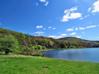
![]()
![]()
![]()
![]()
![]() On Tuesday, May 12th, I wanted to get out and do a longer hike as I had coverage for ambilance calls from 8:30 AM to 2:30 PM. I decided that I wanted to go to Alder Lake to hike to the Beaver Meadow Lean-to which would be better named the Beaver Pond lean-to as the beavers have returned. They have built an impressive dam and there are at least two lodges. They have also built another dam to tunr another beaver meadow back into a pond. I knew I could extend the hike by going to the Millbrook Ridge high point or visiting the falls on Alder Creek below the lake. I started to get ready at 9:45 AM when the temperature was 47 degrees. The skies were mostly sunny with bright blue and white puffy clouds. Sheena was hovering around me as she can always detect when I am getting ready for a hike. I put on my Mammut crew top without a baselayer. I put on a pair of RailRiders hiking pants which are expensive but last along time and have features like deep pockets and a generous cut which I really like. These pants do not have Velcro closures at the ankles to discourage sticks and gravel from getting into my shoes and to combat ticks. I decided to put on my Keen Durand hiking boots which fit well. I added a new pair of Xstance insoles in an effort to find the best support and cushioning for my feet. These insoles have shock absorbing gel pads, TPU arch support, and memory foam cushioning all wrapped in a breathable fabric. The insoles have been hyped by their manufacturer and seemed to be living up to their claims. I decided to wear my Mammut hoody as it has enough zippers to dump heat when needed. I put on my OR BugOut gaiters to block the ticks and fend off the mud I expected to find. I grabbed a pair of Leki Micro Vario poles I have been using for some time because they are light and lock without slipping. I put on a lighweight hat but did not bring gloves. I got my gear and Sheena in my car and left Livingston Manor at 10:00 AM and drove north and west on Old Route 17 toward Roscoe. Just outside of town I turned right on the Beaverkill Road and headed north. I continued on the Beaverkill Road through Lew Beach and Turnwood toward Alder Creek Road where I made a left. I continued to the end on the road where I turned right toward Alder Lake. I saw the gate was open and the access road was in good shape. I drove up the access road very slowly as there are some very rough spots. When I got to the parking area there were two cars parked in the lot. I parked by pulling in and started to get ready to hike. I set my GPS and we started out on the path toward the "lawn" at 10:30 AM with the temperature at 52 degrees.
On Tuesday, May 12th, I wanted to get out and do a longer hike as I had coverage for ambilance calls from 8:30 AM to 2:30 PM. I decided that I wanted to go to Alder Lake to hike to the Beaver Meadow Lean-to which would be better named the Beaver Pond lean-to as the beavers have returned. They have built an impressive dam and there are at least two lodges. They have also built another dam to tunr another beaver meadow back into a pond. I knew I could extend the hike by going to the Millbrook Ridge high point or visiting the falls on Alder Creek below the lake. I started to get ready at 9:45 AM when the temperature was 47 degrees. The skies were mostly sunny with bright blue and white puffy clouds. Sheena was hovering around me as she can always detect when I am getting ready for a hike. I put on my Mammut crew top without a baselayer. I put on a pair of RailRiders hiking pants which are expensive but last along time and have features like deep pockets and a generous cut which I really like. These pants do not have Velcro closures at the ankles to discourage sticks and gravel from getting into my shoes and to combat ticks. I decided to put on my Keen Durand hiking boots which fit well. I added a new pair of Xstance insoles in an effort to find the best support and cushioning for my feet. These insoles have shock absorbing gel pads, TPU arch support, and memory foam cushioning all wrapped in a breathable fabric. The insoles have been hyped by their manufacturer and seemed to be living up to their claims. I decided to wear my Mammut hoody as it has enough zippers to dump heat when needed. I put on my OR BugOut gaiters to block the ticks and fend off the mud I expected to find. I grabbed a pair of Leki Micro Vario poles I have been using for some time because they are light and lock without slipping. I put on a lighweight hat but did not bring gloves. I got my gear and Sheena in my car and left Livingston Manor at 10:00 AM and drove north and west on Old Route 17 toward Roscoe. Just outside of town I turned right on the Beaverkill Road and headed north. I continued on the Beaverkill Road through Lew Beach and Turnwood toward Alder Creek Road where I made a left. I continued to the end on the road where I turned right toward Alder Lake. I saw the gate was open and the access road was in good shape. I drove up the access road very slowly as there are some very rough spots. When I got to the parking area there were two cars parked in the lot. I parked by pulling in and started to get ready to hike. I set my GPS and we started out on the path toward the "lawn" at 10:30 AM with the temperature at 52 degrees.
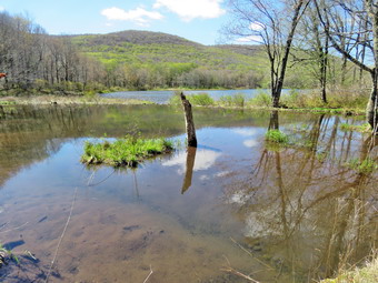 We walked along the path which passes by the stone foundations which marks the last remnants of the Coykendall Mansion. The house had been built as a large hunting lodge and then was gifted to the Boy Scouts of America. When the state took over the property, the mansion fell into disrepair with campers tearing boards away to use for campfires. The state added a fence but it did not deter people so the house was eventually burned to the ground. I decided I wanted to walk directly to the beaver pond and Lena-to without stopping to take pictures. We walked down the left side of the lawn and stopped at the lower part of the lawn. I noticed that the grass was short and two picnic tables had been put out and were in good shape. The water was roaring over the spillway of the dam. I put down my pack and got out the camera. O took some shot of the whole scene and then zoomed in to tale more pictures of Cradle Rock Ridge on one side and Millbrook Ridge on the other. While I was taking pictures, Sheena was running around stretching her legs. When I was done, we started walking east along the trail on the north side of the lake. The trail was wet from the rain the day before with some small streams flowing across the trail and a few muddy spots. The brush and branches that had overgrown the trail were now dead and the walking was much easier. Sheena was happy to be out and ran ahead and then returned to me. We approached the bridges and I noticed the skies were now a little more blue and the sun was shining brightly. We continued on the trail and we crossed the bridges on the trail near the head end of the lake. I could see the beaver dam that impounded some water from the inlet streams was still intact. I stopped to take pictures from the trail. I snapped shots of the beaver dam and Cradle Rock Ridge. As we continued we found that the second bridge had several broken boards on the side and I wished that the DEC would take more interest in maintaining this well-used camping spot. We continued on the trail toward the junction with the Millbrook Ridge Trail. At the point where a path leads to the left to some primitive campsite, some large trees had fallen across the trail. These had been there for some time but now a path ahd been cut to allow easier passage. At the trail junction, I turned left to head toward the lean-to on the Millbrook Ridge Trail but Sheena continued on the trail around the pond. It didn't take her long to realize I ahd turned and she came running back to me. The trail showed more use than I had expected and was relatively clear of branches. There continued to be wet and muddy places on the trail and all the streams were high but easy to cross. There were more large trees that had been across the trail but these had all been cut. We crossed some streams that were almost dry the last time I had visited but were now flowing nicely. Alder Creek had quite a bit of water and we could hear it as it ran downstream over the rocks. The trail is pretty obvious and the blazes easy to see in most places. For the next 1.5 miles the trail climbed and then leveled off several times. The elevation gain is several hundred feet but the grade is never more than 12% and averages around 6%. There isn't too much to see along the way but this day was very pleasant because of the temperature and my mood.
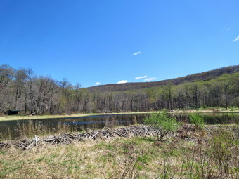 The trail levels off at the first beaver meadow and cross a small stream that feeds it. Sheena took the time to get a drink. I was so happy to be out that I completely missed that we had walked past the first beaver meadow! At 2.2 miles we began the last climb and I found that the going was easier than I thought it would be. I stopped to open some zippers as I was getting very warm. As we started the climb, we came across a few more blowdowns that had also been cut. Some of these were around two feet in diameter! Soon we arrived at the beaver pond. Where there had once been a beaver meadow, there was now a pond with a dam and a beaver lodge. The dam looked as if it had not been worked on in some time and there was a good amount of water leaving the pond. As I looked around I was overcome by the feeling of joy at seeing what God has created! I realized that the return trip would be much easier as it was almost all downhill. We walked off trail just below the dam amd I again took pictures of the dam and the beaver lodge. I used different zooms and different angles. When I was n we walked along the shore of the pond to the lean-to. Roof had Ben completely replaced and the stone fireplace cleaned up. Unfortunately, the privy that had been dismantled by thoughtless hikers ahd not been reconstructed and all that remained was the toilet itself. The large tree that had fallen down in front of the lean-to blocking the view of the pond had been removed. I took a few pictures of the lean-to and then decided to walk out to the shore of the pond. The skies remained blue with a few clouds and there was a breeze. I took some shots of the pond and the hills around it and few of the dam and beaver lodge. After I got a drink, I decided to head to the second beaver pond a little farther up the trail.
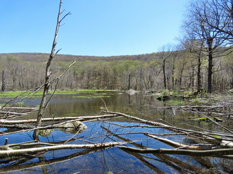 We walked out to the main trail and turned right to walk the trail to the second beaver pond. The very large trees that had been across the trail had been cut to make a clear path. The short trip was more uphill than I remembered but we were soon at the pond. I did not see any new trees cut and the dam appeared to be in the same shape it had been on my last visit. I got out my camera and took a number of pictures of the pond, dam, amd lodge. When I was done, we returned to the main trail and headed back to the parking area. I was hoping to set a quick pace on the way back as the blowdowns had been cleared and the return trip was mostly downhill. The walk did go quickly and we were soon at the loop trail around Alder Lake where we turned right to return the way we came. We crossed the bridges over the inlet streams and continued on the trail toward the parking area. When the trail met the "lawn" we turned right and headed up the hill toward the stonework which is all that remains of the Coykendall hunting lodge. I was struck by the stark stone against the beautiful landscape. I decided I would not take pictures on this day. As we approached the parking area, I noted that it had taken 90 minutes to walk out the trail and 70 minutes to come back. The slower walk out was partly due to the uphills but mostly due to my photographic efforts. I thought about visiting the falls on Alder Creek downstream of the dam but decided not to make the trip. We were back at the car at 1:15 PM after hiking 4.9 miles in 2 hours and 45 minutes with 10 minutes of stopped time. The elevation gain was 640 feet. Our moving speed was 2 MPH and overall speed was 1.8 MPH. The two cars were still in the parking lot and we had not seen any people on the trails.
![]()
![]()
![]()
![]()
![]() On Thursday, May 7th, I really wanted to go for a longer hike as the weather forecast was for blue skies and some sunshine. I had ambulance coverage between 8:30 AM and 2:30 PM but had to be back by 2:30 PM to cover calls. I though we would go to Alder Lake and hike to the Beaver Meadow Lean-to as we had not been there for some time. The plans for a longer hike were put on hold as I had a 7:45 AM ambulance call in Roscoe. After the call my driver and I grabbed some donuts and coffee for the nurses at GH Catskills and the GH Clinic in Livingston Manor. By the time I got home it was 10:30 AM. I decided to wait until Cindy got home from Bible studded to see if she wanted to hike the Parksville Rail Trail. Cindy did not get home until 12:30 PM and did not show much interest in hiking. I decided to hike the Parksville Rail Trail as it is close to home but still gives me a workout if I carry my pack and push the pace. As I began to get ready at 12:45 PM the temperature on the back porch was 48 degrees but the skies were blue with some sun and clouds. The Parksville Rail Trail is under three miles out and back but keeping a quick pace helps increase the difficulty. Sheena actually does get in about twice the mileage that I do as she forges ahead and then comes back! I have transitioned from using a leash all the time to using a GarmimSport PRO electronic collar which has many versatile settings and seems to do the job. This allows Sheena to roam and keeps me sane by not having to yank on her leash. It seems that Sheena likes hiking as she smells my clothes and then runs to sit by the door or wanders around my study watching me get dressed! On this day she could hardly contain herself! I got dressed in a Columbia Omni-shade long-sleeved crew top without a baselayer. I put on a pair of RailRiders hiking pants which are expensive but last along time and have features like deep pockets and a generous cut which I really like. These pants do not have Velcro closures at the ankles to discourage sticks and gravel from getting into my shoes and to combat ticks. I decided to put on my Keen Durand hiking boots which fit well. I added a new pair of Xstance insoles in an effort to find the best support and cushioning for my feet. These insoles have shock absorbing gel pads, TPU arch support, and memory foam cushioning all wrapped in a breathable fabric. The insoles have been hyped by their manufacturer and seemed to be living up to their claims. I decided to wear my Mammut hoody as it has enough zippers to dump heat when needed. I put on my OR BugOut gaiters to block the ticks and fend off the mud I expected to find.
On Thursday, May 7th, I really wanted to go for a longer hike as the weather forecast was for blue skies and some sunshine. I had ambulance coverage between 8:30 AM and 2:30 PM but had to be back by 2:30 PM to cover calls. I though we would go to Alder Lake and hike to the Beaver Meadow Lean-to as we had not been there for some time. The plans for a longer hike were put on hold as I had a 7:45 AM ambulance call in Roscoe. After the call my driver and I grabbed some donuts and coffee for the nurses at GH Catskills and the GH Clinic in Livingston Manor. By the time I got home it was 10:30 AM. I decided to wait until Cindy got home from Bible studded to see if she wanted to hike the Parksville Rail Trail. Cindy did not get home until 12:30 PM and did not show much interest in hiking. I decided to hike the Parksville Rail Trail as it is close to home but still gives me a workout if I carry my pack and push the pace. As I began to get ready at 12:45 PM the temperature on the back porch was 48 degrees but the skies were blue with some sun and clouds. The Parksville Rail Trail is under three miles out and back but keeping a quick pace helps increase the difficulty. Sheena actually does get in about twice the mileage that I do as she forges ahead and then comes back! I have transitioned from using a leash all the time to using a GarmimSport PRO electronic collar which has many versatile settings and seems to do the job. This allows Sheena to roam and keeps me sane by not having to yank on her leash. It seems that Sheena likes hiking as she smells my clothes and then runs to sit by the door or wanders around my study watching me get dressed! On this day she could hardly contain herself! I got dressed in a Columbia Omni-shade long-sleeved crew top without a baselayer. I put on a pair of RailRiders hiking pants which are expensive but last along time and have features like deep pockets and a generous cut which I really like. These pants do not have Velcro closures at the ankles to discourage sticks and gravel from getting into my shoes and to combat ticks. I decided to put on my Keen Durand hiking boots which fit well. I added a new pair of Xstance insoles in an effort to find the best support and cushioning for my feet. These insoles have shock absorbing gel pads, TPU arch support, and memory foam cushioning all wrapped in a breathable fabric. The insoles have been hyped by their manufacturer and seemed to be living up to their claims. I decided to wear my Mammut hoody as it has enough zippers to dump heat when needed. I put on my OR BugOut gaiters to block the ticks and fend off the mud I expected to find.
As we walked out to the car at 1:00 PM, it felt warmer than the thermometer indicated. I put my gear in the back of the car and Sheena in the back seat and drove out Old Route 17 toward Parksville. I turned left under the Quickway overpass onto Service Road. I drove toward Parksville and pulled into the parking area on the right side of the road just after Fox Mountain Rd. There were no cars parked in the lot. When I opened the car door, Sheena came out like a shot and headed for the trail. I decided not to take my pack and push the pace as hard as possible. We started on our hike at 1:15 PM with the temperature at 50 degrees. The trail was only slightly damp at the beginning but I wondered what it would look like in the shade of the trees. Off her leash Sheena runs ahead of us a certain distance and then maintains that distance by waiting or increasing her pace. On this day she seemed to be very interested in the many game trails that stemmed from the rail trail. We were soon under the cover of the trees where the temperature did not seem much cooler. The usual spots had some standing water and mud. These areas were wider and deeper than on our last hike as it ahd rained the night before. Sheena was enjoying the freedom of the hike and the various game tracks she could find. I was happy I wore the Mammut hoody as it blocks the wind well but is not too warm. The trail runs parallel to the Little Beaverkill and the new section of State Route 17. It follows the route of the O&W railroad and is very flat. Sheena was setting a quick pace and I didn't mind as long as she would listen and wait for me when necessary. The mud pits had opened up and there was standing water on parts of the trail. This continued for much of the hike.
I noticed that the noise from the stream was a loud roar and several views showed the water was high and running rapidly. We came to the viewpoint just before the wooden walkways which has a nice view down to the stream. I had decided to just hike and had not even brought a camera to take pictures. We walked across the wooden walkways which were still slippery from being damp. As we approached the bridge just after the walkways, I could see there was water running around both sides of the bridge. I hope the BOCES Construction Trades class can do something about this problem. There was a large patch of mud after the bridge. We came to the landslide that had brought down several trees that had been cut and cleared. This area also had open water and a lot of mud. We negotiated this area and continued toward the falls. As we approached the falls there was a significant increase in noise from the stream. The falls came into view and the water level was een higher than our last trip. I peeked at the falls and then we moved on. I noticed the time was 1:33 PM which means we had made the falls in 18 minutes! We continued onward to the Parksville end of the trail as fast as we could. The remainder of the walk to the other end of the trail went quickly. Sheena took the lead which she sometimes is reluctant to do as there are sometimes dogs at the end of the trail. The large dog across the stream was absent. As we approached the end of the trail, I could here loud music playing but the dogs that are usually outside barking were inside and only making a half-hearted effort.
We tagged the end of the trail at 1:39 PM meaning it had taken us 24 minutes to hike one way and only 6 minutes to get from the falls to the end of the trail. We turned around to head back to the car. We walked quickly back toward the car with Sheena in the lead continuing to wander off trail. Sheena seemed fine and was out ahead of me at times and then rushing back to me before turning around. Within 6 minutes we passed by the falls and continued to push the pace. We soon came to the area of the mudslide and Sheena and I continued our hike after picking our way across the mud. We carefully walked over the slippery surface of the walkways. As we approached the end of the trail, Sheena decided to let off some more energy by executing a set of zoomies. I eventually called her and told her "With" which is the equivalent of "Heel". We arrived back at the car at 2:02 PM after covering the return trip in only 22 minutes. We had hiked 2.7 miles in 47 minutes! The temperature had risen to 52 degrees but the skies were becoming overcast. Sheena seemed fresh and I felt she could have hiked out and back on the trail another time. When we returned home, there had been an ambulance call that my crew had covered.
![]()
![]()
![]()
![]()
![]() On Monday, May 4th, I really wanted to go for a longer hike as the weather forecast was for blue skies and some sunshine. I had ambulance coverage between 8:30 AM and 2:30 PM but had to leave at 3:00 PM for a track meet in Jeffersonville. The plans for a longer hike were put on hold as I had a 5:00 AM ambulance call and did not get back until 7:00 AM. Thought I could manage to get in the hike anyway but was just too tired. I took a "nap" and woke up again at 9:30 AM. I still wanted to get out for a hike even if it was shorter than I had planned. I knew Sheena would be excited as we had been hiking more frequently recently and she expects it. I asked Cindy if she would like to hike and he said "No" despite the nearly ideal weather. I decided to hike the Parksville Rail Trail as it is close to home but still gives me a workout if I carry my pack and push the pace. As I began to get ready at 10:15 AM the temperature on the back porch was 60 degrees and the skies were blue with some sun and clouds. The Parksville Rail Trail is under three miles out and back but keeping a quick pace helps increase the difficulty as does a full backpack. Sheena actually does get in about twice the mileage that I do as she forges ahead and then comes back! I have transitioned from using a leash all the time to using a GarmimSport PRO electronic collar which has many versatile settings and seems to do the job. This allows Sheena to roam and keeps me sane by not having to yank on her leash. It seems that Sheena likes hiking as she smells my clothes and then runs to sit by the door or wanders around my study watching me get dressed! On this day she could hardly contain herself! I got dressed in a Columbia Omni-shade long-sleeved crew top without a baselayer. I put on a pair of RailRiders hiking pants which are expensive but last along time and have features like deep pockets and a generous cut which I really like. These pants do not have Velcro closures at the ankles to discourage sticks and gravel from getting into my shoes and to combat ticks. I decided to put on my Keen Durand hiking boots which fit well. I added a new pair of Xstance insoles in an effort to find the best support and cushioning for my feet. These insoles have shock absorbing gel pads, TPU arch support, and memory foam cushioning all wrapped in a breathable fabric. The insoles have been hyped by their manufacturer and seemed to be living up to their claims. I decided to wear my Mammut hoody as it has enough zippers to dump heat when needed. The hoody also packs small enough to easily fit in my pack. I put on my OR BugOut gaiters to block the ticks and fend off the mud I expected to find.
On Monday, May 4th, I really wanted to go for a longer hike as the weather forecast was for blue skies and some sunshine. I had ambulance coverage between 8:30 AM and 2:30 PM but had to leave at 3:00 PM for a track meet in Jeffersonville. The plans for a longer hike were put on hold as I had a 5:00 AM ambulance call and did not get back until 7:00 AM. Thought I could manage to get in the hike anyway but was just too tired. I took a "nap" and woke up again at 9:30 AM. I still wanted to get out for a hike even if it was shorter than I had planned. I knew Sheena would be excited as we had been hiking more frequently recently and she expects it. I asked Cindy if she would like to hike and he said "No" despite the nearly ideal weather. I decided to hike the Parksville Rail Trail as it is close to home but still gives me a workout if I carry my pack and push the pace. As I began to get ready at 10:15 AM the temperature on the back porch was 60 degrees and the skies were blue with some sun and clouds. The Parksville Rail Trail is under three miles out and back but keeping a quick pace helps increase the difficulty as does a full backpack. Sheena actually does get in about twice the mileage that I do as she forges ahead and then comes back! I have transitioned from using a leash all the time to using a GarmimSport PRO electronic collar which has many versatile settings and seems to do the job. This allows Sheena to roam and keeps me sane by not having to yank on her leash. It seems that Sheena likes hiking as she smells my clothes and then runs to sit by the door or wanders around my study watching me get dressed! On this day she could hardly contain herself! I got dressed in a Columbia Omni-shade long-sleeved crew top without a baselayer. I put on a pair of RailRiders hiking pants which are expensive but last along time and have features like deep pockets and a generous cut which I really like. These pants do not have Velcro closures at the ankles to discourage sticks and gravel from getting into my shoes and to combat ticks. I decided to put on my Keen Durand hiking boots which fit well. I added a new pair of Xstance insoles in an effort to find the best support and cushioning for my feet. These insoles have shock absorbing gel pads, TPU arch support, and memory foam cushioning all wrapped in a breathable fabric. The insoles have been hyped by their manufacturer and seemed to be living up to their claims. I decided to wear my Mammut hoody as it has enough zippers to dump heat when needed. The hoody also packs small enough to easily fit in my pack. I put on my OR BugOut gaiters to block the ticks and fend off the mud I expected to find.
As we walked out to the car at 10:30 AM, it felt warmer than the thermometer indicated. I put my gear in the back of the car and Sheena in the back seat and drove out Old Route 17 toward Parksville. I turned left under the Quickway overpass onto Service Road. I drove toward Parksville and pulled into the parking area on the right side of the road just after Fox Mountain Rd. I was surprised to see several pickups and a jeep with NYSDOT markings. There was also one car parked in the lot. I thought that perhaps the DOT was planning some work on the trail. I got out of the car and made sure Sheena's ecollar was adjusted correctly as I let her out of the car. When I opened the car door, Sheena came out like a shot and headed for the trail. I set my GPS and we started on our hike at 10:49 AM with the temperature at 62 degrees. The trail was bare and only slightly damp at the beginning but I wondered what it would look like in the shade of the trees. Off her leash Sheena runs ahead of us a certain distance and then maintains that distance by waiting or increasing her pace. On this day she seemed to be very interested in the many game trails that stemmed from the rail trail. I noticed that a man had gotten out of the car and was following us. I was determined to stay ahead of him. We were soon under the cover of the trees where the temperature did not seem much cooler. The usual spots had some standing water and mud but for the most part they were easy to avoid. Sheena was enjoying the freedom of the hike and the various game tracks she could find. I was happy I wore the Mammut hoody as it blocks the wind well but is not too warm. The trail runs parallel to the Little Beaverkill and the new section of State Route 17. It follows the route of the O&W railroad and is very flat. Sheena was setting a quick pace and I didn't mind as long as she would listen and wait for us when necessary. The mud pits had opened up and there was standing water on parts of the trail. This continued for much of the hike.
I noticed that the noise from the stream was a roar and several views showed the water was high and running rapidly. We came to the viewpoint just before the wooden walkways which has a nice view down to the stream. I had decided to just hike and avoid photography as I had pictures from recent hikes. We walked across the wooden walkways which were still slippery from being damp. As we approached the bridge just after the walkways, I saw a group of men gathered on or near the bridge. I stopped for a minute to put Sheena on her leash. We continued toward the bridge and I recognized some of the men and they all recognized me. One man was the construction trades instructor at BOCES and he had some of his students with him. After we greeted each other, he explained that they were looking at the bridge as a project for their class. I told him that it made me very happy. Sheena and I continued our hike and I noticed that the man who had been following was no conger following. There was a large patch of mud after the bridge. We came to the landslide that had brought down several trees that had been cut and cleared. This area also had open water and a lot of mud. We negotiated this area and continued toward the falls. As we approached the falls there was a significant increase in noise from the stream. The falls came into view and the water level was the same as on our last trip. I peeked at the falls and then we moved on. We continued onward to the Parksville end of the trail as fast as we could. The remainder of the walk to the other end of the trail went quickly. Sheena took the lead which she sometimes is reluctant to do as there are sometimes dogs at the end of the trail. The large dog across the stream was absent. As we approached the end of the trail, the dogs that are usually outside barking were back but their efforts were half-hearted at best.
We tagged the end of the trail at 11:14 AM meaning it had taken us 25 minutes to hike one way. We turned around to head back to the car. It seemed the temperature had stayed the same but there was more sun. We walked quickly back toward the car with Sheena in the lead continuing to wander off trail. Sheena seemed fine and was out ahead of me at times and then rushing back to me before turning around. Within 6 minutes we passed by the falls and continued to push the pace. We soon came to the area of the mudslide where the men we had seen before were now gathered. I stopped to talk for a few minutes when I recognized the ,an that had followed us was Frank DeMayo,a good friend and Town of Liberty Supervisor. After a few minutes, I excused myself and Sheena and I continued our hike. We carefully walked over the slippery surface of the walkways. As we approached the end of the trail, Sheena decided to let off some more energy by executing a set of zoomies. I eventually called her and told her "With" which is the equivalent of "Heel". We arrived back at the car at 11:37 AM after covering the return trip in only 23 minutes. W had hiked 2.7 miles in 48 minutes! The temperature had risen to 64 degrees and there was more sun. Sheena seemed fresh and I felt she could have hiked out and back on the trail another time. When we returned home, there had been an ambulance call that my crew had covered.
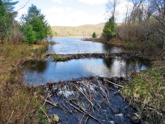
![]()
![]()
![]()
![]()
![]() On Friday, May 1st my plan was to get up and hike from Alder Lake to the Beaver Meadow Lean-to. There were no ambulance calls overnight so I got some sleep and woke up at 9:00 AM. I knew Cindy would not want to hike the hills at Alder Lake so Iasked her if she would like to hike the Loggers Loop at Frick Pond. She said "Yes" and we began to get ready at 10:15 AM with Sheena making sure we could not forget her. Sheena and I had been out three days in a row and it seemed she was beginning to expect we would hike very day! The temperature was 50 degrees but the skies were blue with some sun and puffy white clouds. I got dressed in a my Mammut crew top without a baselayer. I put on a pair of RailRiders hiking pants which are expensive but last a long time and have features like deep pockets and a generous cut which I really like. I decided to put on my Keen Durand hiking boots which fit well. I added a new pair of Xstance insoles in an effort to find the best support and cushioning for my feet. These insoles have shock absorbing gel pads, TPU arch support, and memory foam cushioning all wrapped in a breathable fabric. The insoles have been hyped by their manufacturer and seemed to be living up to their claims. I grabbed a pair of Leki Micro Vario poles I have been using for some time because they are light and lock without slipping. I also donned a light hat and my OR BugOut gaiters. I put our gear in the car and drove out DeBruce Road at 10:30 AM. After 6 miles, I turned left on Mongaup Road and continued to where the road split. I stayed to the left on Beech Mountain Road following another car. We both pulled into the smaller parking area for Frick Pond. The temperature was 52 degrees at the trailhead and a slight breeze was blowing. The other driver stayed in their car as we got ready to hike out to Frick Pond. I set my GPS and made sure Sheena's ecollar was turned on as we started out on the woods road that leads to the Quick Lake Trail at 10:50 AM.
On Friday, May 1st my plan was to get up and hike from Alder Lake to the Beaver Meadow Lean-to. There were no ambulance calls overnight so I got some sleep and woke up at 9:00 AM. I knew Cindy would not want to hike the hills at Alder Lake so Iasked her if she would like to hike the Loggers Loop at Frick Pond. She said "Yes" and we began to get ready at 10:15 AM with Sheena making sure we could not forget her. Sheena and I had been out three days in a row and it seemed she was beginning to expect we would hike very day! The temperature was 50 degrees but the skies were blue with some sun and puffy white clouds. I got dressed in a my Mammut crew top without a baselayer. I put on a pair of RailRiders hiking pants which are expensive but last a long time and have features like deep pockets and a generous cut which I really like. I decided to put on my Keen Durand hiking boots which fit well. I added a new pair of Xstance insoles in an effort to find the best support and cushioning for my feet. These insoles have shock absorbing gel pads, TPU arch support, and memory foam cushioning all wrapped in a breathable fabric. The insoles have been hyped by their manufacturer and seemed to be living up to their claims. I grabbed a pair of Leki Micro Vario poles I have been using for some time because they are light and lock without slipping. I also donned a light hat and my OR BugOut gaiters. I put our gear in the car and drove out DeBruce Road at 10:30 AM. After 6 miles, I turned left on Mongaup Road and continued to where the road split. I stayed to the left on Beech Mountain Road following another car. We both pulled into the smaller parking area for Frick Pond. The temperature was 52 degrees at the trailhead and a slight breeze was blowing. The other driver stayed in their car as we got ready to hike out to Frick Pond. I set my GPS and made sure Sheena's ecollar was turned on as we started out on the woods road that leads to the Quick Lake Trail at 10:50 AM.
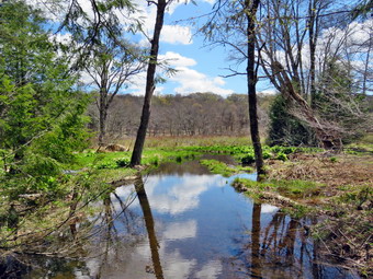 The Quick Lake Trail is sited along a woods road that leads to Frick Pond The trail was covered in standing water and there was water flowing on the trails and across the trail in many places. This was due to the rain the day and night before. Sine the NYNJTC decided to replace local maintainers with the Catskill Trail crew the trail conditions have grown steadily worse. At Gravestone Junction two small white birches were hanging over the trail with broken branches hanging down right at head level. The trails around the pond serve as an introduction to hiking for many people. My maintainers and I always kept them in top shape but that seems to be a thing of the past. We stayed to the left at Gravestone Junction to keep on the Quick Lake Trail to the bridge at the outlet end of Frick Pond. There were muddy patches all along the trail. Some patches stretch across the entire trail while others were easily avoided. We walked down the hill to the bridge where I dropped my pack and got out the camera. Cindy and I were both surprised at how much water was in the pond. I had seen the beaver dams on a previous trip but they were even more impressive now. The main dam stretched from shore to shore and there was a secondary dam downstream from the main dam. There was water flowing over and through the dams but there was a nice pond impounded. I could also see a beaver lodge on the right shore. The light was very good for photography so I began taking shots of the dams and the pond. I also took pictures of Sheena on the bridge and of the pond with Beech Mountain behind it. She I was done, I picked up my pack and we continued along the west side of the pond. There were many muddy areas and many where water had collected and it wasn't easy to avoid all of them. At the junction with the Big Rock Trail, we stayed to the left on the Quick Lake Trail. This trail also had lots of wet and muddy places and finding a good route was challenging. There had been one large blowdown blocking the trail but this had been cut and removed. I hoped that some of the other blowdowns had also been cleared. When we arrived at the stream through the woods, we found that the water level was very high. I took some pictures of the stream and the small waterfall upstream. We decided to use some stepping stones to cross even though the water was high. We both made it across while Sheena just jumped from one bank to the other. We continued up the trail working our way around pools of water and muddy areas. As we were walking, I began to get warm so I opened the zippers on the hoody. We continued until we reached Iron Wheel Junction where I took some pictures of the namesake and of Sheena sitting next to it.
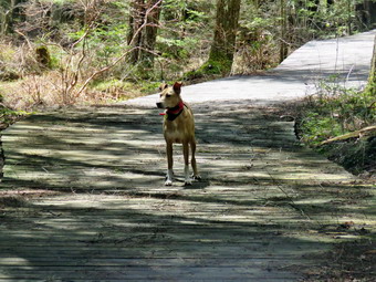 I asked Cindy if she wanted to turn around or continue. She decided we would continue so we turned right and started out on the Logger's Loop. I was very surprised that there was almost no water and very little mud on the trail. Most times there are large puddles and plenty of mud. We hiked along the trail until we came to a large culvert where there was a small waterfall falling off the bank on the left side of the trail. This area had some water as the culverts and ditches were partially blocked. We continued on the trail passing the area where there is sometimes a small, seasonal pond on the left. On my last trip the pond was overflowing and there was a large puddle on the trail. Today this area was dry! I walked off the trail to the left and took some pictures of the area. When I was done, we continued on down the hill to Times Square. I considered simply following the Logger's Loop but finally decided to turn right on the Big Rock trail. We both like the wooden walkways on the west side of Frick Pond. We walked on the trail which was wet and muddy until we came to the two bridges over the inlet streams to Frick Pond. I noticed a small waterfall and positioned myself to take some photographs. I cam e back to the bridges and took pictures of the wetlands at the head of Frick Pond. We continued over the second bridge and through the evergreen forest. We came to the wooden walkways and we stopped so that I could take some pictures of the walkways and Sheena on the walkways. We continued along the trail to the junction with the Quick Lake Trail where we turned left. We walked back along the west side of the pond to the bridge. I had not intend to stop but the skies were now lighter and very blue. I took a number of shots which contrasted with what I had taken earlier. We walked up the hill to Gravestone Junction. I wanted to check out the blowdowns by the primitive campsites to see if they had been removed. I turned left and walked along the trail for only a few minutes until the campsites came into view. Both large blowdowns were still there! We returned to Gravestone Junction and turned left to catch up with Cindy who was a short distance ahead of us. We walked out the woods road to our car. There were now no other cars parked in either lot. It was 1:05 PM and we had hiked 4.1 miles in 2 hours and 15 minutes with 12 minutes of stopped time. Our overall average was only 1.7 mph but our moving speed was 2.0 mph which reflected my time for photography. On the way home we passed the car that had been in the parking lot. It was parked on the pavement of the wrong side of the road! The driver appeared to be foraging by the stream. No surprises!
![]()
![]()
![]()
![]()
![]() On Thursday, April 30th I planned to get out for a longer hike to Alder Lake as I had ambulance coverage from 8:30 AM to 2:00 PM. When I woke up it was cold and still sprinkling a little so I decided to get some more sleep. When I finally got up at 10:00 AM, I decided I would go to Round Top as I had not been there for some time and knew it might need some maintenance. Round Top is always available for a hike and although there are few surprises it is always better than staying at home. I did some work at home and then started to get ready to hike at 11:45 AM with the temperature at 52 degrees on the back porch. Sheena was jumping around and would not leave my side showing she was ready to get outside. She likes to smell my hiking clothes to make sure I am getting dressed in the right clothes. I got dressed in a my Mammut crew top without a baselayer. I put on a pair of RailRiders hiking pants which are expensive but last a long time and have features like deep pockets and a generous cut which I really like. I decided to put on my Keen Durand hiking boots which fit well. I added a new pair of Xstance insoles in an effort to find the best support and cushioning for my feet. These insoles have shock absorbing gel pads, TPU arch support, and memory foam cushioning all wrapped in a breathable fabric. The insoles have been hyped by their manufacturer and seemed to be living up to their claims. I grabbed a pair of Leki Micro Vario poles I have been using for some time because they are light and lock without slipping. I also donned a light hat and my OR BugOut gaiters. At noon I made sure Sheena's ecollar was turned on and put her on her leash. We walked out the door to start the hike and headed down the driveway and to the street. Sheena knows to pause and look both ways until I say "Cross". We crossed the street and walked to the church parking lot. We walked to the back of the church and began the ascent of the steepest hill behind the church. The hill is short but gets the circulation pumping and is the steepest and longest climb on the "trail." I held my poles in one hand and Sheena's leash in the other as Sheena pulled my up the hill. We did stop once on the way to the top of the hill. I could really feel that I had not been hiking consistently lately. At the top we paused for a minute so I could look around at the hills that surround the hamlet of Livingston Manor. The skies were overcast with only a little sunshine. We continued the hike by turning left at the trailhead. The trail was samp with a covering of slippery leaves.
On Thursday, April 30th I planned to get out for a longer hike to Alder Lake as I had ambulance coverage from 8:30 AM to 2:00 PM. When I woke up it was cold and still sprinkling a little so I decided to get some more sleep. When I finally got up at 10:00 AM, I decided I would go to Round Top as I had not been there for some time and knew it might need some maintenance. Round Top is always available for a hike and although there are few surprises it is always better than staying at home. I did some work at home and then started to get ready to hike at 11:45 AM with the temperature at 52 degrees on the back porch. Sheena was jumping around and would not leave my side showing she was ready to get outside. She likes to smell my hiking clothes to make sure I am getting dressed in the right clothes. I got dressed in a my Mammut crew top without a baselayer. I put on a pair of RailRiders hiking pants which are expensive but last a long time and have features like deep pockets and a generous cut which I really like. I decided to put on my Keen Durand hiking boots which fit well. I added a new pair of Xstance insoles in an effort to find the best support and cushioning for my feet. These insoles have shock absorbing gel pads, TPU arch support, and memory foam cushioning all wrapped in a breathable fabric. The insoles have been hyped by their manufacturer and seemed to be living up to their claims. I grabbed a pair of Leki Micro Vario poles I have been using for some time because they are light and lock without slipping. I also donned a light hat and my OR BugOut gaiters. At noon I made sure Sheena's ecollar was turned on and put her on her leash. We walked out the door to start the hike and headed down the driveway and to the street. Sheena knows to pause and look both ways until I say "Cross". We crossed the street and walked to the church parking lot. We walked to the back of the church and began the ascent of the steepest hill behind the church. The hill is short but gets the circulation pumping and is the steepest and longest climb on the "trail." I held my poles in one hand and Sheena's leash in the other as Sheena pulled my up the hill. We did stop once on the way to the top of the hill. I could really feel that I had not been hiking consistently lately. At the top we paused for a minute so I could look around at the hills that surround the hamlet of Livingston Manor. The skies were overcast with only a little sunshine. We continued the hike by turning left at the trailhead. The trail was samp with a covering of slippery leaves.
 At the first trail junction, I followed Sheena as she continued up the hill toward the lookout. Sheena shot up the hill but it took me a little longer. At the top we turned left on the unmarked path put to the lookout. There were no leaves on the trees but the view was limited as more trees had grown up. I found the spot wit the best view of the school and the other buildings in town. I dropped my pack and took out the camera. I took pictures of the school and downtown. After that, I directed Sheena to the upper lookout where she sat and posed for pictures! When I was done, I packed up and we walked back out to the main trail. we turned left on the main trail and followed it up to the upper lookout where the trail turned right and started to ascend through the woods. I was surprised that there were only a few small branches and sticks that I removed from the trail with a flick of my hiking poles. We passed the "Sitting Rock" and climb the short but steep hill. As the trail leveled, I found a small blowdown across the trail. I put my pack down and tried to pull the blowdown off the trail. When that didn't work, I got out the saw and cut it in two places. This allowed me to remove the center section and throw it off the trail. I noticed that the sustained aerobic work of cutting the blowdown was ore difficult than when I had been in better shape. When I was done, we continued to the intersection with the blue trail. I decided to turn right to do a figure 8 as that would help me cover all the trails.
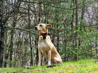 We walked the yellow trail along the base of Round Top to the next junction with the blue trail. I removed several large branches and one small blowdown without having to use my saw. At the trail junction, we turned left and started up the blue trail toward the summit. We passed the white trail and continued over the summit. On the way down the blue trail, we ran into another large blowdown on the trail. This one I was able to lift and shift off the trail. We walked a few more steps and turned left on the switchback. After a short distance, we found two small blowdowns across the trail. I put down the pack and used my saw to cut the first blowdown and drag it off the trail. The second one was also easy to cut and remove. I replaced the saw in my pack and we walked the rest of the switchback out to the main trail. We turned left on the yellow trail and walked along the base of Round Top to the next junction with the blue trail. We again turned left and started up toward the summit. This time we turned left on the white crossover trail and headed back toward the blue trail on the other side of the hill. Along the way I removed a few smaller branches. We came to one larger blowdown which I thought I might be able to pull off the trail. As I lifted it, I found it was heavier than I thought but it easily slid downhill once I got it started. We continued out to the blue trail and turned left to walked down to the junction with the yellow trail. We again turned left and walked along the base of Round Top. This time we turned right at the junction with the blue trail. We walked the trail downhill to the woods road and headed back to the first trail junction. Along the way there was one blowdown sticking out into the trail. I cut it and removed it from the trail. We walked to the first trail junction and turned left to walk out to Te trailhead. We turned right and walked down the hill to the back of the church. I put Sheena on her leash and we walked through the parking lot to the road. We turned right and then left into our driveway. We were back home at 1:30 PM after hiking over 2 miles in 1 hour and 30 minutes. I was glad there were no ambulance calls while we were hiking.
![]()
![]()
![]()
![]()
![]() On Wednesday, April 29th, I really wanted to go for a hike even the weather forecast was for overcast skies and a chance of showers. This was a stark contrast to higher temperatures over the last weeks. I had ambulance coverage between 8:30 AM and 2:30 PM. I knew Sheena would be excited as we had been hiking more frequently recently and she expects it. I asked Cindy if she would like to hike and he said "Yes" despite the less than ideal weather. We decided to hike the Parksville Rail Trail as it is close to home and flat which Cindy prefers. As we began to get ready at 9:45 AM the temperature on the back porch was 55 degrees and the skies were completely overcast. Sheena loves warm places and has a short coat but also seems to be okay with cooler temperatures. The Parksville Rail Trail is under three miles out and back but keeping a quick pace helps increase the difficulty as does a full backpack. Sheena actually does get in about twice the mileage that I do as she forges ahead and then comes back! I have transitioned from using a leash all the time to using a GarmimSport PRO electronic collar which has many versatile settings and seems to do the job. This allows Sheena to roam and keeps me sane by not having to yank on her leash. It seems that Sheena likes hiking as she smells my clothes and then runs to sit by the door or wanders around my study watching me get dressed! On this day she could hardly contain herself! I got dressed in a Columbia Omni-shade long-sleeved crew top without a baselayer. I put on a pair of RailRiders hiking pants which are expensive but last along time and have features like deep pockets and a generous cut which I really like. These pants do not have Velcro closures at the ankles to discourage sticks and gravel from getting into my shoes and to combat ticks. I decided to put on my Keen Durand hiking boots which fit well. I added a new pair of Xstance insoles in an effort to find the best support and cushioning for my feet. These insoles have shock absorbing gel pads, TPU arch support, and memory foam cushioning all wrapped in a breathable fabric. The insoles have been hyped by their manufacturer and seemed to be living up to their claims. I decided to wear my Mammut hoody as it has enough zippers to dump heat when needed. The hoody also packs small enough to easily fit in my pack. I put on my OR BugOut gaiters to block the ticks and fend off the mud I expected to find.
On Wednesday, April 29th, I really wanted to go for a hike even the weather forecast was for overcast skies and a chance of showers. This was a stark contrast to higher temperatures over the last weeks. I had ambulance coverage between 8:30 AM and 2:30 PM. I knew Sheena would be excited as we had been hiking more frequently recently and she expects it. I asked Cindy if she would like to hike and he said "Yes" despite the less than ideal weather. We decided to hike the Parksville Rail Trail as it is close to home and flat which Cindy prefers. As we began to get ready at 9:45 AM the temperature on the back porch was 55 degrees and the skies were completely overcast. Sheena loves warm places and has a short coat but also seems to be okay with cooler temperatures. The Parksville Rail Trail is under three miles out and back but keeping a quick pace helps increase the difficulty as does a full backpack. Sheena actually does get in about twice the mileage that I do as she forges ahead and then comes back! I have transitioned from using a leash all the time to using a GarmimSport PRO electronic collar which has many versatile settings and seems to do the job. This allows Sheena to roam and keeps me sane by not having to yank on her leash. It seems that Sheena likes hiking as she smells my clothes and then runs to sit by the door or wanders around my study watching me get dressed! On this day she could hardly contain herself! I got dressed in a Columbia Omni-shade long-sleeved crew top without a baselayer. I put on a pair of RailRiders hiking pants which are expensive but last along time and have features like deep pockets and a generous cut which I really like. These pants do not have Velcro closures at the ankles to discourage sticks and gravel from getting into my shoes and to combat ticks. I decided to put on my Keen Durand hiking boots which fit well. I added a new pair of Xstance insoles in an effort to find the best support and cushioning for my feet. These insoles have shock absorbing gel pads, TPU arch support, and memory foam cushioning all wrapped in a breathable fabric. The insoles have been hyped by their manufacturer and seemed to be living up to their claims. I decided to wear my Mammut hoody as it has enough zippers to dump heat when needed. The hoody also packs small enough to easily fit in my pack. I put on my OR BugOut gaiters to block the ticks and fend off the mud I expected to find.
As we walked out to the car at 10:15 AM, the sky was still overcast. I put our gear in the back of the car and Sheena in the back seat and drove out Old Route 17 toward Parksville. I turned left under the Quickway overpass onto Service Road. I drove toward Parksville and pulled into the parking area on the right side of the road just after Fox Mountain Rd. There were no cars parked in the lot when we arrived. I got out of the car and made sure Sheena's ecollar was adjusted correctly as I let her out of the car. When I opened the car door, Sheena came out like a shot and headed for the trail. I set my GPS and we started on our hike at 10:33 AM with the temperature at 56 degrees. The trail was bare and only slightly damp at the beginning but I wondered what it would look like in the shade of the trees. Off her leash Sheena runs ahead of us a certain distance and then maintains that distance by waiting or increasing her pace. On this day she seemed to be very interested in the many game trails that stemmed from the rail trail. We were soon under the cover of the trees where the temperature did not seem much cooler as there was no sun. The usual spots had some standing water and mud but for the most part they were easy to avoid. Sheena was enjoying the freedom of the hike and the various game tracks she could find. I was happy I wore the Mammut hoody as it blocks the wind well but is not too warm. The trail runs parallel to the Little Beaverkill and the new section of State Route 17. It follows the route of the O&W railroad and is very flat. Sheena was setting a quick pace and I didn't mind as long as she would listen and wait for us when necessary. The mud pits had opened up and there was standing water on parts of the trail. This continued for much of the hike.
I noticed that the noise from the stream was a roar and several views showed the water was high and running rapidly. We came to the viewpoint just before the wooden walkways which has a nice view down to the stream. I had decided to just hike and avoid photography as I had pictures from recent hikes. We walked across the wooden walkways which were still slippery from being damp. The area before the bridge had running water and more water was passing under the bridge. There was a large patch of mud after the bridge. We came to the landslide that had brought down several trees that had been cut and cleared. This area also had open water and a lot of mud. We negotiated this area and continued toward the falls. As we approached the falls there was a significant increase in noise from the stream. The falls came into view and the water level was the same as on our last trip. I peeked at the falls and then we moved on. We continued onward to the Parksville end of the trail. The remainder of the walk to the other end of the trail went quickly. Sheena took the lead which she sometimes is reluctant to do as there are sometimes dogs at the end of the trail. The large dog across the stream was absent. As we approached the end of the trail, the dogs that are usually outside barking were nowhere to be found!
We tagged the end of the trail at 11:06 AM meaning it had taken us 34 minutes to hike one way. We turned around to head back to the car. It seemed the temperature had stayed the same but there was more sun. We walked quickly back toward the car with Sheena in the lead continuing to wander off trail. Sheena seemed fine and was out ahead of us at times and then rushing back to us before turning around. Within 8 minutes we passed by the falls and continued to push the pace. We soon came to the bridge and the walkways, where we carefully walked over the slippery surface. As we approached the end of the trail, Sheena decided to let off some more energy by executing a set of zoomies. I eventually called her and told her "With" which is the equivalent of "Heel". We arrived back at the car at 11:37 AM after hiking 2.7 miles in 1 hour and 4 minutes. The return trip was about the same as the trip out. The temperature had risen to 58 degrees and there was more sun. Sheena seemed fresh and I felt she could have hiked out and back on the trail another time. When we returned home, there had been no ambulance calls.
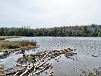
![]()
![]()
![]()
![]()
![]() On Thursday, April 28th I wanted to get out on a longer hike as I had ambulance coverage from 8:00 AM to 2:30 PM. This meant I wanted to spend time hiking not driving and preferred to go somewhere I had not been in some time. I decided to go to Long Pond as it is about 6 miles and isn't too far from my house. The temperature was 66 degrees as I was getting ready at 10:30 AM. Cindy has a women's bible study and would not be home until noon so it was just Sheena and me to hike. As I started to get ready Sheena was there to watch my every move. Sheena kept me in sight as I got ready to go making sure she would not be forgotten. I got dressed in a Columbia Omni-shade long-sleeved crew top without a baselayer. I put on a pair of RailRiders hiking pants which are expensive but last along time and have features like deep pockets and a generous cut which I really like. These pants do not have Velcro closures at the ankles to discourage sticks and gravel from getting into my shoes and to combat ticks. I decided to put on my Keen Durand hiking boots which fit well. I added a new pair of Xstance insoles in an effort to find the best support and cushioning for my feet. These insoles have shock absorbing gel pads, TPU arch support, and memory foam cushioning all wrapped in a breathable fabric. The insoles have been hyped by their manufacturer and seemed to be living up to their claims. I decided to wear my Mammut hoody as it has enough zippers to dump heat when needed. The hoody also packs small enough to easily fit in my pack. I put on my OR BugOut gaiters to block the ticks and fend off the mud I expected to find. I put my gear in the back of the car and Sheena in the back seat as we left Livingston Manor at 10:50 AM with skies that were overcast with some blue and a little sun. We headed out DeBruce Road toward Long Pond for about 8 miles to Flugertown Road where I made a left. I drove up the road and found that the pavement change to gravel where there used to be a hard surface. In a short distance, the pavement returned making me think that the road was being repaired and would son be paved. Shortly after this I pulled into the lot on the right and parked in the lot where no other cars were parked. Some signs reminded me that there had been work on the bridge farther up the road. The temporary bridge had large rectangular holes in it and I might have to carry Sheena across! After I pulled into the lot, I started to get ready by setting my GPS. We got started on the trail by crossing the first bridge at 10L12 AM. The skies were still overcast and the temperature was 59 degrees. Some insects gathered and I regretted forgetting a hat and insect repellent.
On Thursday, April 28th I wanted to get out on a longer hike as I had ambulance coverage from 8:00 AM to 2:30 PM. This meant I wanted to spend time hiking not driving and preferred to go somewhere I had not been in some time. I decided to go to Long Pond as it is about 6 miles and isn't too far from my house. The temperature was 66 degrees as I was getting ready at 10:30 AM. Cindy has a women's bible study and would not be home until noon so it was just Sheena and me to hike. As I started to get ready Sheena was there to watch my every move. Sheena kept me in sight as I got ready to go making sure she would not be forgotten. I got dressed in a Columbia Omni-shade long-sleeved crew top without a baselayer. I put on a pair of RailRiders hiking pants which are expensive but last along time and have features like deep pockets and a generous cut which I really like. These pants do not have Velcro closures at the ankles to discourage sticks and gravel from getting into my shoes and to combat ticks. I decided to put on my Keen Durand hiking boots which fit well. I added a new pair of Xstance insoles in an effort to find the best support and cushioning for my feet. These insoles have shock absorbing gel pads, TPU arch support, and memory foam cushioning all wrapped in a breathable fabric. The insoles have been hyped by their manufacturer and seemed to be living up to their claims. I decided to wear my Mammut hoody as it has enough zippers to dump heat when needed. The hoody also packs small enough to easily fit in my pack. I put on my OR BugOut gaiters to block the ticks and fend off the mud I expected to find. I put my gear in the back of the car and Sheena in the back seat as we left Livingston Manor at 10:50 AM with skies that were overcast with some blue and a little sun. We headed out DeBruce Road toward Long Pond for about 8 miles to Flugertown Road where I made a left. I drove up the road and found that the pavement change to gravel where there used to be a hard surface. In a short distance, the pavement returned making me think that the road was being repaired and would son be paved. Shortly after this I pulled into the lot on the right and parked in the lot where no other cars were parked. Some signs reminded me that there had been work on the bridge farther up the road. The temporary bridge had large rectangular holes in it and I might have to carry Sheena across! After I pulled into the lot, I started to get ready by setting my GPS. We got started on the trail by crossing the first bridge at 10L12 AM. The skies were still overcast and the temperature was 59 degrees. Some insects gathered and I regretted forgetting a hat and insect repellent.
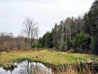 I hoped we could set a quick pace but knew that the water and mud I expected to find would slow us down. This would be the longest hike I had attempted in some time ad I did not know how I would feel. The first .6 miles gains about 350 feet to the highest point on the hike. It isn't very steep but does act as a nice warm-up! I set off very fast and found I was soon out of breath. This trail is in the Willowemoc Wild Forest but on a snowmobile trail not assigned to the NYNJTC. Once the trail leveled it was easier walking but there were many wet and muddy spots. I tried to get Sheena to follow me around the worst spots but she likes to walk through the middle of the mud. Most of the muddy spots showed tracks from an ATV or small pickup both of which should not be on the trail unless for "official" purposes. We did run into two large blowdowns on the trail which would block UTV access for rescuing hikers. I made a note to call a local ranger to report the blowdowns. He could cut them or alert an operations team. At 1.1 miles we were at the spur trail that leads down to the shore of Long Pond. We turned right and went down to the pond so that I could take some pictures. At the shores of the pond I dropped my pack and got out my camera to take some pictures. The path to the actual shore of the pond was flooded with water and was very muddy. I told Sheena to stay where she was and she sat down by my pack. The skies were a flat blue with a few clouds and plenty of overcast. I took a few pictures of different angles and zooms. I returned to my pack where I got a bar and a drink before packing up as we returned to the main trail. We turned right and were soon at the first trail junction. I knew I could turn left to "nail out" but I felt strong enough to try for 6 miles. We turned right at the junction at 1.3 miles and continued to find wet and muddy places on the trail. Some of these spots ran from one side of the trail to the other and were hard to avoid. We continued to find a few blowdowns but most were small enough to remove with hand tools. By 11:15 AM we had walked 1.8 miles and were passing the yellow spur trail to the lean-to. I though about going to the lean-to as a crew of young volunteers had done a lot of work to improve it. In the end I decided to bypass the lean-to to make sure I was home at the right time.
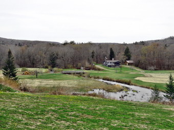 After passing the trail to the lean-to, we continued to find many wet and muddy places with detours solidified by many hikers. There isn't much to see on this section of trail so I concentrated on avoiding the deep mud as much as possible without ruining the trail. We continued on the main trail to the point where it intersects a woods road at 2.6 miles. We turned left on the woods road and found puddles of water and lots of mud! We followed the road until the intersection with Basily Road at 2.85 miles where we continued on Basily Road by bearing left. This section of road continued to be wet and muddy but the mud was, for the most part, easily avoided. It did seem to get getting warmer the longer we hiked and I was sweating with the workout. As we approached the Peters Hunting Camp, I got ready to put Sheena on her leash if anyone was at the camp. In the past, the road to the hunting camp crossed a stream which the beavers had dammed. There was a small wooden bridge but both the road and the bridge were usually flooded. During our last trip I found the road had been elevated and was completely dry with a culvert to allow the stream to pass beneath. Large rocks had been placed to resist erosion and packed earth formed the road. I stopped to take some pictures of the beaver pond and the new road. We followed the road as it crossed a field in front of the camp and came to the bridge over the stream near the camp. The bridge is showing signs of wear from snowmobiles passing over it even though there is a sign that states "Private Bridge". I have secured permission to hike across this land in the past and "Stay on the trail" signs seem to indicate that the owners will allow hikers. I assume the "Private Bridge - No thru traffic" refers to motorized vehicles and not hikers. The water in the stream was very high and the ford was not visible. There were at least 3 large piles of logs and evidence of an extensive logging operation. We crossed the bridge to continue the trip back to the car and started up the little hill from the hunting camp. We stopped again so that I could take a few shots of the valley which looked peacefully bucolic. The area downstream of the bridge was now part pond and part wetland which was evidence of a beaver dam.
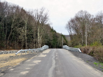 Once we started walking again we kept a fast pace as the road now had less water and mud. The road is packed gravel until it breaks out of the forest where it is paved. There were several places to camp along the road and one had a parked car with no occupants. Several of the campsites looked well-used and had stone fireplaces or fire rings. As we walked Sheena alerted and came back to me. I saw a NYSP SUV approaching followed by a NYS DEC Forest Ranger pickup. I told Sheena to sit as the vehicles went by. I wondered where they were going as the roads dead end and there are only hunting camps in the area. I expected them to return by the time we got to the car but we never saw them again. Soon we were at the end of the gravel road where the pavement started. There was a sign indicating road work ahead and I could only imagine that the SC DPW was working on one of the bridges. We continued down the road toward the parking area and our car at a near record pace. As we came to the bridge it was clear the work was finished and the new bridge had been installed. For some reason the DPW had neglected to remove the signs! I dropped my pack just before the bridge and took out my camera. I took pictures of the approach to the bridge and then walked onto the bridge itself. I took pictures of the bridge and the abutments that had been built upstream out of large boulders. I also took some pictures downstream. I returned to my pack, stowed the camera and we headed down the road toward the trailhead. We continued at an accelerated pace back to the parking area. When we arrived, there were still no cars parked. We were back at the car at 1:15 PM having hiked 5.9 miles in 3 hours with 22 minutes of stopped time. The elevation gain was only about 560 feet most of which was at the beginning of the hike.
![]()
![]()
![]()
![]()
![]() On Monday, April 20th, I really wanted to go for a hike even the weather forecast was for snow and rain showers with overcast skies and temperatures only in the high 30s! This was a stark contrast to the 70's and 80's of last week. I had ambulance coverage between 8:30 AM and 2:30 PM. I knew Sheena would be excited as we had been hiking more frequently recently and she expects it. I did some work around the house and then decided ir was time to make a decision. I asked Cindy if she would like to hike and he said "Yes" despite the less than ideal weather. We decided to hike the Parksville Rail Trail as we could turn around at any time it Sheena was too cold. As we began to get ready at 10:45 AM the temperature on the back porch was 37 degrees and some sun was beginning to peek through the overcast. Sheena loves warm places and has a short coat but also seems to be okay with cooler temperatures. The Parksville Rail Trail is under three miles out and back but keeping a quick pace helps increase the difficulty as does a full backpack. Sheena actually does get in about twice the mileage that I do as she forges ahead and then comes back! I have transitioned from using a leash all the time to using a GarmimSport PRO electronic collar which has many versatile settings and seems to do the job. This allows Sheena to roam and keeps me sane by not having to yank on her leash. It seems that Sheena likes hiking as she smells my clothes and then runs to sit by the door or wanders around my study watching me get dressed! On this day she could hardly contain herself! I got dressed in a Patagonia wool 1/4 zip top without a baselayer. I put on a pair of insulated hiking pants which seemed to have no maker's label attached. The pants fit well and seemed to have just the right insulation. For boots I decided to put on my Keen Durand hiking boots which fit well. I added a new pair of Xstance insoles in an effort to find the best support and cushioning for my feet. These insoles have shock absorbing gel pads, TPU arch support, and memory foam cushioning all wrapped in a breathable fabric. The insoles have been hyped by their manufacturer and seemed to be living up to their claims. I have recently bought several brands of socks and put on a pair of OTC socks from The Buffalo Wool Company. These socks are a mixture of Merino wool and bison fiber. They have a cushioned lower and a slighty thinner upper. I put on my Baerskin fleece hoody which is a bit warmer than my Mammut hoody. I grabbed a pair of Leki Micro Vario poles I have been using for some time because they are light and lock without slipping. I chose a light hat to cover my ears and a light pair of gloves. I remembered to wear my OR BugOut gaiters to repel any mud or ticks we might encounter. I decided to take my pack as I could carry my camera and it added a little difficulty to an otherwise easy trail. As we walked out to the car at 11:05 AM, the sky was still overcast but the sun was shining through. I put our gear in the back of the car and Sheena in the back seat and drove out Old Route 17 toward Parksville. I turned left under the Quickway overpass onto Service Road. I drove toward Parksville and pulled into the parking area on the right side of the road just after Fox Mountain Rd. There was one cars parked in the lot when we arrived. I got out of the car and made sure Sheena's ecollar was adjusted correctly as I let her out of the car. When I opened the car door, Sheena came out like a shot and headed for the trail. We started on our hike at 11:20 AM with the temperature at 36 degrees. There were a few flakes in the air and a good breeze was blowing.
On Monday, April 20th, I really wanted to go for a hike even the weather forecast was for snow and rain showers with overcast skies and temperatures only in the high 30s! This was a stark contrast to the 70's and 80's of last week. I had ambulance coverage between 8:30 AM and 2:30 PM. I knew Sheena would be excited as we had been hiking more frequently recently and she expects it. I did some work around the house and then decided ir was time to make a decision. I asked Cindy if she would like to hike and he said "Yes" despite the less than ideal weather. We decided to hike the Parksville Rail Trail as we could turn around at any time it Sheena was too cold. As we began to get ready at 10:45 AM the temperature on the back porch was 37 degrees and some sun was beginning to peek through the overcast. Sheena loves warm places and has a short coat but also seems to be okay with cooler temperatures. The Parksville Rail Trail is under three miles out and back but keeping a quick pace helps increase the difficulty as does a full backpack. Sheena actually does get in about twice the mileage that I do as she forges ahead and then comes back! I have transitioned from using a leash all the time to using a GarmimSport PRO electronic collar which has many versatile settings and seems to do the job. This allows Sheena to roam and keeps me sane by not having to yank on her leash. It seems that Sheena likes hiking as she smells my clothes and then runs to sit by the door or wanders around my study watching me get dressed! On this day she could hardly contain herself! I got dressed in a Patagonia wool 1/4 zip top without a baselayer. I put on a pair of insulated hiking pants which seemed to have no maker's label attached. The pants fit well and seemed to have just the right insulation. For boots I decided to put on my Keen Durand hiking boots which fit well. I added a new pair of Xstance insoles in an effort to find the best support and cushioning for my feet. These insoles have shock absorbing gel pads, TPU arch support, and memory foam cushioning all wrapped in a breathable fabric. The insoles have been hyped by their manufacturer and seemed to be living up to their claims. I have recently bought several brands of socks and put on a pair of OTC socks from The Buffalo Wool Company. These socks are a mixture of Merino wool and bison fiber. They have a cushioned lower and a slighty thinner upper. I put on my Baerskin fleece hoody which is a bit warmer than my Mammut hoody. I grabbed a pair of Leki Micro Vario poles I have been using for some time because they are light and lock without slipping. I chose a light hat to cover my ears and a light pair of gloves. I remembered to wear my OR BugOut gaiters to repel any mud or ticks we might encounter. I decided to take my pack as I could carry my camera and it added a little difficulty to an otherwise easy trail. As we walked out to the car at 11:05 AM, the sky was still overcast but the sun was shining through. I put our gear in the back of the car and Sheena in the back seat and drove out Old Route 17 toward Parksville. I turned left under the Quickway overpass onto Service Road. I drove toward Parksville and pulled into the parking area on the right side of the road just after Fox Mountain Rd. There was one cars parked in the lot when we arrived. I got out of the car and made sure Sheena's ecollar was adjusted correctly as I let her out of the car. When I opened the car door, Sheena came out like a shot and headed for the trail. We started on our hike at 11:20 AM with the temperature at 36 degrees. There were a few flakes in the air and a good breeze was blowing.
The trail was bare and only slightly damp at the beginning but I wondered what it would look like in the shade of the trees. It was a pleasure to be able to walk without worrying about getting a good place to plant your feet in the snow and ice. Off her leash Sheena runs ahead of us a certain distance and then maintains that distance by waiting or increasing her pace. On this day she seemed to be very interested in the many game trails that had been under the snow. We were soon under the cover of the trees and the trail remand completely devoid of snow and ice. The usual spots had some standing water and mud but for the most part they were easy to avoid. Sheena was enjoying the freedom of the hike and the various game tracks she could find. She did not seem cold as she had on some previous hikes. I was happy I wore the Baerskin hoody as it is warm and blocks the wind well. The trail runs parallel to the Little Beaverkill and the new section of State Route 17. It follows the route of the O&W railroad and is very flat. Sheena was setting a quick pace and I didn't mind as long as she would listen and wait for me when necessary. The wind was perpendicular to the trail and I didn't notice it much except in the more open spaces. The biggest change in the trail conditions from my previous hikes was the mud pits that had opened up and the standing water on parts of the trail. This continued for much of the hike. I noticed that the noise from the stream was a roar and several views showed the water was high and running rapidly. We came to the viewpoint just before the wooden walkways which has a nice view down to the stream. I had almost decided to just hike and avoid the photography but I took a peek and cage my mind. I took out the camera a got some shots of the stream and the sky. When I finished, we walked across the wooden walkways which were still slippery even without a ridge of ice. The area before the bridge had running water and more water was passing under the bridge. There was a large patch of mud after the bridge.
We came to the landslide that had brought down several trees that had been cut and cleared. This area also had open water and a lot of mud. We negotiated this area and continued toward the falls. As we approached the falls there was a significant increase in noise from the stream. The falls came into view and the water level was even higher than on our last trip. I started down the path to the streambed with Sheena right behind me. As usual, Cindy stayed on the rail trail relaxing on the picnic table. Sheena and I worked our way down to the edge of the stream. I was careful to pick where I put me feet as the wet rocks with wetter leaves and moss were treacherous. When we got to the bottom, Sheena began to sniff around while I got out the camera. Sheena immediately posed on a rock with the falls in the background. I took some shots of her and then turned my attention to the falls. I took some shots of the whole scene including the falls and the rapids below the falls. I zoomed in and took pictures at different zoom levels to isolate different parts of the scene. At one point Cindy yelled something down to me but I could not hear her over the roar of the falls. I assumed that there might be a hiker with a dog so I made sure Sheena stayed with me. When I was done, I stowed the camera and we worked our way back up the bank. Cindy confirmed that there was a hiker with his golden retriever. We had met them both before and his dog is well-behaved but wants to play. I took some more pictures of the falls from above including the raids above the falls. My battery ran out just as I took the last picture!
We continued onward to the Parksville end of the trail. The remainder of the walk to the other end of the trail went quickly. Sheena took the lead which she sometimes is reluctant to do as there are sometimes dogs at the end of the trail. The large dog across the stream was absent. As we approached the end of the trail, the dogs that are usually outside barking were nowhere to be found! We tagged the end of the trail at 12:05 PM meaning it had taken us 45 minutes to hike and for me to take pictures. We turned around to head back to the car. It seemed the temperature had stayed the same and that the wind was still blowing gently but there was more sun. We walked quickly back toward the car with Sheena in the lead continuing to wander off trail. Sheena seemed fine and was not favoring any of her paws because of the cold. Within 7 minutes we passed by the falls and continued to push the pace. We soon came to the bridge and the walkways, where we carefully walked over the slippery surface. As we approached the end of the trail, Sheena decided to let off some more energy by executing a set of zoomies. I eventually called her and told her "With" which is the equivalent of "Heel". We arrived back at the car at 12:35 PM after hiking 3 miles in 1 hour and 15 minutes. The return trip was faster than the trip out because of our pace and the photography on the way out. The temperature had risen to 40 degrees and the wind was still blowing but there was more sun. Sheena seemed fresh and I felt she could have hiked out and back on the trail another time. When we returned home, there had been an ambulance call which the crew covered.
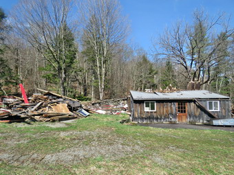
![]()
![]()
![]()
![]()
![]() On Tuesday, September 2nd I wanted to get out for a longer hike as I had ambulance coverage from 8:00 AM to 2:00 PM. There were no ambulance calls overnight but I decided to get some sleep to make up for the last few nights. The pager awoke me at 8:55 AM but my crew was on it! I got up and ate some breakfast and felt much better. In addition, Sheena was giving clear indications she wanted to hike. I started to get ready to hike at 10:00 AM with the temperature at 70 degrees and Sheena watching my every move. I decided to hike the Parksville Rail Trail from Parksville toward Livingston Manor. I got dressed in a new Columbia Omni-Shade Omni-Wick shirt without a baselayer. I put on a pair of RailRiders hiking pants which are expensive but last a long time and have features like deep pockets and a generous cut which I really like. I thought about wearing a pair of low-cut and lighter hiking shoes but thought the trail might be wet and muddy. I decided to put on my Keen Durand hiking boots which fit well. I added a new pair of Xstance insoles in an effort to find the best support and cushioning for my feet. These insoles have shock absorbing gel pads, TPU arch support, and memory foam cushioning all wrapped in a breathable fabric. The insoles have been hyped by their manufacturer and seemed to be living up to their claims. I grabbed a pair of Leki Micro Vario poles I have been using for some time because they are light and lock without slipping. I also put on my OR BugOut gaiters for the ticks that are becoming active. I put the ecollar on Sheena and turned it on. At 10:20 AM I put my gear in the car and Sheena in the back seat. I headed out Old Route 17 across the Flats and then took Old Route 17 and Service Road to the point where they meet Fox Mountain Road. Just after this intersection is the western parking area for the rail trail. The parking lot was empty. I set my GPS to record our efforts. I put Sheena on her leash for the short road walk to the beginning of the trail.
On Tuesday, September 2nd I wanted to get out for a longer hike as I had ambulance coverage from 8:00 AM to 2:00 PM. There were no ambulance calls overnight but I decided to get some sleep to make up for the last few nights. The pager awoke me at 8:55 AM but my crew was on it! I got up and ate some breakfast and felt much better. In addition, Sheena was giving clear indications she wanted to hike. I started to get ready to hike at 10:00 AM with the temperature at 70 degrees and Sheena watching my every move. I decided to hike the Parksville Rail Trail from Parksville toward Livingston Manor. I got dressed in a new Columbia Omni-Shade Omni-Wick shirt without a baselayer. I put on a pair of RailRiders hiking pants which are expensive but last a long time and have features like deep pockets and a generous cut which I really like. I thought about wearing a pair of low-cut and lighter hiking shoes but thought the trail might be wet and muddy. I decided to put on my Keen Durand hiking boots which fit well. I added a new pair of Xstance insoles in an effort to find the best support and cushioning for my feet. These insoles have shock absorbing gel pads, TPU arch support, and memory foam cushioning all wrapped in a breathable fabric. The insoles have been hyped by their manufacturer and seemed to be living up to their claims. I grabbed a pair of Leki Micro Vario poles I have been using for some time because they are light and lock without slipping. I also put on my OR BugOut gaiters for the ticks that are becoming active. I put the ecollar on Sheena and turned it on. At 10:20 AM I put my gear in the car and Sheena in the back seat. I headed out Old Route 17 across the Flats and then took Old Route 17 and Service Road to the point where they meet Fox Mountain Road. Just after this intersection is the western parking area for the rail trail. The parking lot was empty. I set my GPS to record our efforts. I put Sheena on her leash for the short road walk to the beginning of the trail.
 We started out at 10:30 AM with the temperature right at 72 degrees. A slight breeze was blowing but the skies were bright and sunny with some billowing white clouds. We walked on Service Road toward Fox Mountain Road and turned left to walk underneath the Quickway. We walked back to the intersection of Fox Mounatin Road and Benton Hollow Road and hopped the guard rail where I took Sheena off her leash. We immediately came to what was left of the trestle supports that carried the trail tracks over the stream. I noticed what remained of a painting on the trestle. I had seen this painting before but had not realized it was a memorial to NASCAR driver Davey Allison #28 who drove the Texaco-Havoline Ford car. Allison died in a helicopter crash in 1993. Unfortunately, the paint was peeling and hardly readable anymore. We walked up the trail to left to the top of the trestle. As we entered the shade of the trees, it immediately seemed a little cooler. The trail was well defined and stretched ahead for some distance. Like most rail trails it is very straight. Town of Liberty Supervisor Frank DeMayo had told me that this was state land and the town had an agreement from the state to use it. The hope is to connect the Parksville Rail Trail to all the sections that stretch as far as Livingston Manor. We started to walk along the trail and I noticed there was quite a bit of traffic on the Quickway but that I could shut out the noise. The land dropped off steeply to the Little Beaverkill on the right. On the left were some "cliffs" which were the result of the railroad cutting a path for the tracks. We continued to walk along the well-defined trail which was only damp and a little muddy in places. It was a pleasant walk without many insects which surprised me. There were a number of blowdowns on the trail which could be removed with hand tools but the trail is not maintained at this point. I walked over or around these and removed some small branches on the trail as we walked. Sheena jumped over all the blowdowns. She can take a running start or seemingly jump from a standing start. There are two places along the trail where there are piles of garbage. It is hard to determine why they are there. Both piles had tarps over them which seemed to indicate someone once valued the items but people have begun to remove them. There are some very interesting signs. A VW bug was just over the bank on the right after the first pile of debris. We soon came to a gate on the trail which was odd since it was state land. We walked around the gate and continued on the rail trail. There was a path to the left just after the gate. It looked interesting but we stayed on the rail trail.
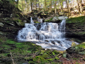 Soon we came to a small pond on the right with a red building behind it. The building looked to be in good shape but the windows were all boarded up. There was a definite path between the pond on the right and the wetlands on the left of the trail. It looked like a beaver trail to me but I could not see any dam, lodge, or even any trees that the beavers had cut. The level of the pond was higher than usual as we had heavy rain the night before. After hiking about 1.3 miles, we came to a driveway on the left which leads to the Sonoma Falls property. This is private property even though it is not posted. Hiking without permission is trespassing. At one time there was a campground on the property. Some local business people bought the property and built a cider mill and market. They took the time to construct some hiking trails along the stream. I remember that the falls were very nice with separate drops which increased in height the farther upstream one ventured. The business closed when not enough people would go out of their way to visit. It was 11:00 AM and it had only taken us 30 minutes to hike the 1.3 miles. We turned left and walked toward the buildings. To my surprise the main building and one out building had been torn down and all that remained was two piles of rubble. It looked like the stainless steel sink used to wash be apples and a machine to turn the apples into pulp for pressing had been saved. I put down my pack and got out the camera. The sun was very bright making the photography challenging. I walked to the front of what was left of the main building and took pictures of those remains. I am sure the owners felt they had to take down the buildings as they had been vacant for so many years. The roof of the main building had been collapsing. Vandals have painted graffiti on other buildings inside and out. It made me very sad to see this once busy attraction deteriorate so badly it had to be destroyed. We walked back to my pack at the stream just behind the building and I got my first look at the falls. They had not changed much and the water level was high. There was a falls right in front and one visible farther upstream an still another in the distance. I started taking the first of what would be a large number of pictures. I perched on some rocks and got a nice all of the falls. I picked up the pack and walked a little uphill where there was a nice viewpoint and I took some more pictures. I put the camera back in the pack as we walked the trail up to the second falls and I found a way to get down to the streambed to get a clear shot. There are several areas where there is laid up stone which made me think there had been mills along the stream at some point. I again put the camera in the pack as we walked a little farther upstream to the third set of falls. The amount of water coming over the falls was more than I had seen before and I found an angle to get some shots. This falls is formed not be rock formation but by a man-made dam.
 We continued to walk and came to a small pond at the base of the highest falls so far. From the pond I took some shots of the falls and some pictures downstream toward the dam. The light was almost prefect! We continued to walk along the stream until I found a good viewpoint for the falls. I had to experiment with zoom and angles and settings to get some shots. I took some shots and of the lower falls and a few of the upper. We walked up the bank and then up the hill toward the upper falls. We walked as far as we could and then descended some to get better pictures of the upper falls. When I was done, we walked back up the bank and then up the steep hill toward the uppermost falls. We walked along the edge of the gorge until I could get some shots of the last falls. This is by far the highest falls and trying to get all of it in one shot was challenging. I took a few shots and then moved a little more upstream for a better view of the upper drop of the three that make up these falls. The water level continued to be outstanding and the noise the falls was making was impressive. I took my last shots of the falls and then packed up to hike to the bridge over the stream at the top. The bridge was in poor shape. I was able to get some pictures of another small falls formed by a dam that impounds a pond. We turned around and walked the woods road until we came to a point where one branch goes straight ahead and the other turns left. We have hiked straight ahead several times but it is a bushwhack and usually very wet. I was also trying to avoid the ticks as much as possible so we turned left. We followed the woods road downhill all the way back to the remains of the buildings. We walked back out to the rail trail and Idecided to continue the hike to Old Liberty Road. We turned left and walked along the completely flat trail with wetlands on the right and "cliffs" on the left. These cliffs were formed by the railroad blasting a clear path for the tracks. The walk to Old Liberty Road went quickly and we were at the gate in 8 minutes. We immediately turned around and hiked back to the driveway to Sonoma Falls in 7 minutes. It wasn't very long before we were at the rail trail at the point near the gate. Sheena alerted and we saw an ATV coming toward us. It stopped and the driver and I greeted each other. It wasn't long before we realized we knew each. He seemed surprised when I told him about the removal of the Sonoma Falls building. We spent at least 15 minutes talking. He filled me in on the history of the land and the O&W. Eventually we parted as Sheena and I began a fast-paced walk back to the car. We made good time as there wasn't anything to hold us back. I was thirsty as I had decided not to bring a water bottle. Sheena had gotten some water from the various stream along the way. We were back at the car at 12:50 PM having hiked over 4 miles in 2 hours and 20 minutes with 15 minutes of stopped time for photography and conversation. The ascent was over 300 feet almost all of which was the climb to the waterfalls. I do hope the plans to connect the sections of the rail trails are successful! I also hope that someone reopens Sonoma Falls to the public in some form as it is a beautiful setting.
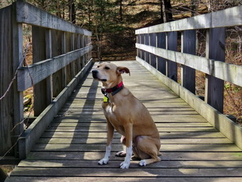
![]()
![]()
![]()
![]()
![]() On Tuesday, April 14th, I wanted to get out for a longer hike after sticking to shorter hikes on the rail trail. I was supposed to have ambulance coverage from 8:00 AM to 2:00 PM which would allow me 6 hours to drive and hike. I intended to get up early and go to either Bramley Mt or Balsam Lake Mt since they both have fire towers. When I awoke at 7:00 AM it was very foggy so I thought might try the six mile loop around Hodge and Frick Ponds and leave the fire towers for another day. I had some things to take care of around the house and the fog finally dissipated around We started to get ready at 10:00 AM, the temperature on the back porch was 58 degrees with mostly overcast skies with only a little blue. As usual, Sheena was excited but was trying to be the "good dog". I got dressed in my Mammut crew top with no baselayer. I put on a pair of insulated hiking pants which seemed to have no maker's label attached. The pants fit well and seemed to have just the right insulation. I knew that this might be a little overkill. For boots I decided to put on my Keen Durand boots which fit well. I have recently bought several brands of socks and put on a pair of crew socks from Ecosox. These socks are primarily bamboo fiber and are soft but wear resistant. I put on my Mammut hoody which has a lot of zippers to dump heat when needed. I grabbed a pair of Leki Micro Vario poles I have been using for some time because they are light and lock without slipping. I decided to take a light hat and light gloves knowing I would probably leave them in the car as it was so warm. I also decided not to wear my OR Crocodile gaiters as they are very warm. I put my gear in the back and Sheena in the backseat and headed out the DeBruce Road at 10:20 AM. After 6 miles, at Mongaup Pond Road, I turned left and continued to follow the road bearing left onto Beech Mountain Road at the fork. When we arrived in the parking area there were no cars parked in either lot. Sheena was acting as if she hadn't hiked in a month as she ran around and headed for the trail. I left my hat and gloves in the car. The temperature was 57 degrees and the skies were now mostly blue with white clouds and a slight breeze blowing. I set my GPS as we got ready to head out on the Flynn Trail. We crossed the road and began our hike at 10:40 AM.
On Tuesday, April 14th, I wanted to get out for a longer hike after sticking to shorter hikes on the rail trail. I was supposed to have ambulance coverage from 8:00 AM to 2:00 PM which would allow me 6 hours to drive and hike. I intended to get up early and go to either Bramley Mt or Balsam Lake Mt since they both have fire towers. When I awoke at 7:00 AM it was very foggy so I thought might try the six mile loop around Hodge and Frick Ponds and leave the fire towers for another day. I had some things to take care of around the house and the fog finally dissipated around We started to get ready at 10:00 AM, the temperature on the back porch was 58 degrees with mostly overcast skies with only a little blue. As usual, Sheena was excited but was trying to be the "good dog". I got dressed in my Mammut crew top with no baselayer. I put on a pair of insulated hiking pants which seemed to have no maker's label attached. The pants fit well and seemed to have just the right insulation. I knew that this might be a little overkill. For boots I decided to put on my Keen Durand boots which fit well. I have recently bought several brands of socks and put on a pair of crew socks from Ecosox. These socks are primarily bamboo fiber and are soft but wear resistant. I put on my Mammut hoody which has a lot of zippers to dump heat when needed. I grabbed a pair of Leki Micro Vario poles I have been using for some time because they are light and lock without slipping. I decided to take a light hat and light gloves knowing I would probably leave them in the car as it was so warm. I also decided not to wear my OR Crocodile gaiters as they are very warm. I put my gear in the back and Sheena in the backseat and headed out the DeBruce Road at 10:20 AM. After 6 miles, at Mongaup Pond Road, I turned left and continued to follow the road bearing left onto Beech Mountain Road at the fork. When we arrived in the parking area there were no cars parked in either lot. Sheena was acting as if she hadn't hiked in a month as she ran around and headed for the trail. I left my hat and gloves in the car. The temperature was 57 degrees and the skies were now mostly blue with white clouds and a slight breeze blowing. I set my GPS as we got ready to head out on the Flynn Trail. We crossed the road and began our hike at 10:40 AM.
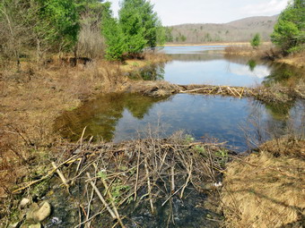 The Flynn Trail is sited along what used to be Beech Mountain Road which was the access for the Beech Mountain Boy Scout Camp. We walked the trail through the woods which was damp in places but not muddy. We started out slowly but soon were keeping a good pace. We turned right on the woods road and began a consistent climb which slowed me down a but. The path was narrow and it was obvious a stream of water had run down the trail during the recent rains. The trail gains a little over 600 feet in 1.7 miles to the highest point at the junction with the Big Rock Trail. We passed the hemlock that used to form a tunnel but was cleared by the DEC. We began to find some small branches on the trail which had come down in the winds from various storms. We continued to find similar conditions for the rest of the hike. The day was getting warmer as the sun came out full force and the weather. I began to warm up even though I only had a single layer. I decided I would take off the Mammut hoody and store it in my pack. On the way up the trail we came to the rock ledges on the right side of the trail. I sometimes take pictures here but decided that I might not take any pictures on this day. As we approached and the clearing to the right of the trail, I debated walking up to the field but decided against it. It was a beautiful day and the sun was shining on the rocks and the trail. I noticed that I was very relaxed and decided it was partly due to the sounds of the winds and the birds. Sheena was keeping mostly to the trail and coming back to check on me occasionally. We descended a little and then began walking uphill. We were soon at the junction with the Big Rock Trail. I was a little tired and I needed to be back before 2:00 PM so I decided to leave the 6 mile loop for another day. We turned left to walk down the Big Rock Trail. It was 11:35 AM and we had hiked 1.75 miles uphill in 55 minutes.
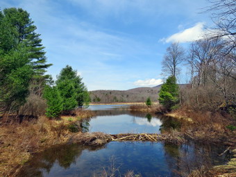 The Big Rock Trail was only a little damp as we started down the long descent. The hike down the trail went well and more quickly than I expected. It was definitely easier than the uphill hike. This trail can be tricky as there are three levels that make it seem like the bottom of the hill. On this day the descents seemed to go quickly and I was not discouraged. We were soon at Times Square and I thought about turning right to hike up and around the Logger's Loop to add some distance to our hike. I decided against this as it was getting late and we continued our hike by walking straight across Times Square to stay on the Big Rock Trail. The Big Rock Trail around the back of Frick Pond can be very wet and this day was no exception. Sheena tends to hike right through the water and mud as was getting filthy! There were several very muddy spots and two large puddles on the trail which I avoided. We crossed the two small bridges over the inlets to the pond and I decided not to stop to take a few pictures. One of the outlet streams looked as if the water was going underground and then shooting up like a fountain. When we got to the area that was covered by tall evergreens, I pushed on through as I had taken pictures here very recently. The wooden boardwalks continue to show wear with many boards loose and other beginning to rot. Much of the boardwalk now "floats" in midair as the supports are rotting. The local rangers and the DEC field office have been alerted several times but don't really seem to care.
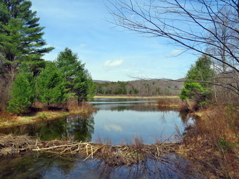 The rest of the trail was damp with several wet and muddy spots. At the next trail junction we turned left on the Quick Lake Trail to head for the bridge across the outlet of Frick Pond. We walked along the west side of Frick Pond to the bridge across the outlet of the pond. The mudhole was wet but not muddy as the drainage work and the stepping stones did their job. I stopped at the bridge to admire two new beavers dams that had been constructed over the last two weeks. They were holding back most of the water and the level of the water now made it look like Frick Pond again. I hope that no one will disturb the dams as they have done in the past. I dropped my pack and got out the camera. I took a few shots of Sheena on the bridge. I then took pictures of the pond and the dams at various angles and zooms. I also photographed Beech Mountain and the out let downstream of the bridge. When I was done, put the camera away and shouldered my pack. Sheena and I then walked up the hill and continued to Gravestone Junction. We passed the Lobdell memorial marker. The marker is a memorial to two children who died in the 1930's in a fire that consumed their cabin. The trail to the memorial was well-worn but the marker was standing intact. The trail back to the register was damp and muddy in spots but not as wet as I has expected. We passed the trail register heading toward the parking area and continued straight ahead to follow the woods road out to the car. We arrived at the car at 12:50 PM having hiked 4.0 miles in 2 hours and 10 minutes with an elevation gain of 670 feet. Our overall average speed was just under 2 MPH with a moving average of 2.1 MPH. The temperature had risen to 76 degrees!
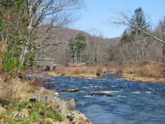
![]()
![]()
![]()
![]()
![]() On Friday, April 10th, I planned to get a hike in to make 3 days this week despite ambulance calls. I had ambulance coverage until 2:00 PM but thought I would do a shorter hike so that Cindy could go. I slept until 10:00 AM catching up on sleep I had lost responding to calls at night. The temperature was 64 degrees and the forecast was that it would get warmer. I asked Cindy if she would like to hike along the Beaverkill at the campgrounds. She said "Yes" as soon as she returned from the store. I thought the Beaverkill Campgrounds was a good choice as I expected the level of the water in the stream to be high from after the recent rainfall. We started to get ready at 11:30 AM with blue skies and plenty of sun. As usual, Sheena was excited but was trying to be the "good dog". I got dressed in my Mammut crew top with no baselayer. I put on a pair of insulated hiking pants which seemed to have no maker's label attached. The pants fit well and seemed to have just the right insulation. For boots I decided to put on my Keen Durand boots which fit well. I have recently bought several brands of socks and put on a pair of OTC socks from The Buffalo Wool Company. These socks are a mixture of Merino wool and bison fiber. They have a cushioned lower and a slighty thinner upper. I put on my Mammut hoody which has a lot of zippers to dump heat when needed. I grabbed a pair of Leki Micro Vario poles I have been using for some time because they are light and lock without slipping. I decided against a hat and gloves as it was so warm. I also decided not to wear my OR Crocodile gaiters as the route might be wet but not muddy. I put our gear in the back of the car and Sheena in the back seat and left the house at 11:45 AM. I drove out Old Route 17 toward Roscoe and turned right on Beaverkill Road. As we started the descent into the Beaverkill Valley, I turned left on Campsite Road and followed it down to the parking area near the Beaverkill Covered Bridge. There were several cars parked in the lot with no one inside. There was a man preparing to hike with two dogs and, unfortunately, he was headed across the bridge on the same route we would take. A glance at the river showed that the level was not quite as high as our last trip but was stretching from high on one shore to high on the other.
On Friday, April 10th, I planned to get a hike in to make 3 days this week despite ambulance calls. I had ambulance coverage until 2:00 PM but thought I would do a shorter hike so that Cindy could go. I slept until 10:00 AM catching up on sleep I had lost responding to calls at night. The temperature was 64 degrees and the forecast was that it would get warmer. I asked Cindy if she would like to hike along the Beaverkill at the campgrounds. She said "Yes" as soon as she returned from the store. I thought the Beaverkill Campgrounds was a good choice as I expected the level of the water in the stream to be high from after the recent rainfall. We started to get ready at 11:30 AM with blue skies and plenty of sun. As usual, Sheena was excited but was trying to be the "good dog". I got dressed in my Mammut crew top with no baselayer. I put on a pair of insulated hiking pants which seemed to have no maker's label attached. The pants fit well and seemed to have just the right insulation. For boots I decided to put on my Keen Durand boots which fit well. I have recently bought several brands of socks and put on a pair of OTC socks from The Buffalo Wool Company. These socks are a mixture of Merino wool and bison fiber. They have a cushioned lower and a slighty thinner upper. I put on my Mammut hoody which has a lot of zippers to dump heat when needed. I grabbed a pair of Leki Micro Vario poles I have been using for some time because they are light and lock without slipping. I decided against a hat and gloves as it was so warm. I also decided not to wear my OR Crocodile gaiters as the route might be wet but not muddy. I put our gear in the back of the car and Sheena in the back seat and left the house at 11:45 AM. I drove out Old Route 17 toward Roscoe and turned right on Beaverkill Road. As we started the descent into the Beaverkill Valley, I turned left on Campsite Road and followed it down to the parking area near the Beaverkill Covered Bridge. There were several cars parked in the lot with no one inside. There was a man preparing to hike with two dogs and, unfortunately, he was headed across the bridge on the same route we would take. A glance at the river showed that the level was not quite as high as our last trip but was stretching from high on one shore to high on the other.
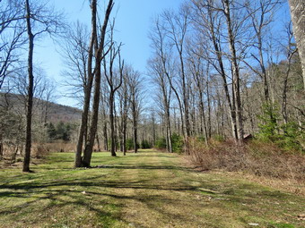 I let Sheena out of the car and put her on her leash. We started our hike at 12:05 PM by walking out of the parking lot to the bridge with the temperature at 68 degrees. When we got to the other side, the gate that blocks the road along the river and through the old campsites was missing. I looked at the trail and saw that it had no snow or ice on it. We turned left on a woods road that parallels the river and started down the short hill. At the bottom of the hill I let Sheena off her leash as I did not see the man and his two dogs. I had decided to take some pictures on the way out. When we got to the spring house on the right I snapped a few shots of the ditch that runs from the spring which had some water plants already growing. When we got to the first culvert, I noticed that the path down to the edge of the stream was eroded and very steep. The rocks were damp and had some snow on them so I decided not to attempt to get down to the stream that way. I did find a route just after the culvert and worked my way down to the edge of the stream with my camera. Sheena followed me but was careful to stay away from the edge of the water. I took pictures of the stream trying to capture the sheer volume and velocity of the water. When I was done, we continued our walk along the woods road which did not have even a patch on ice or snow. Sheena was running ahead of us back and forth following game trails and sniffing the air.
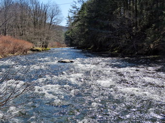 Along the way, the picnic tables blended into the landscape. The whole area had a haunted feeling enhanced by the sound of the flowing water. On the trail we passed by several areas with picnic tables. These tables sit unused and rotting along the road, a testimony to better days when this area had campsites. Now this area is used for day use only. We walked by more tables which had not been used in years. I stopped to take a few shots of the woods road and the picnic tables. Soon we came to what was once a bathroom for some campsites that had long since disappeared. There were more tables in this area. We stopped and I walked to the stream where rocks had been piled up and contained by wire screen. I walked to the edge and carefully stood on some rocks to take more pictures of the stream in both directions. The bright sunlight made taking the pictures difficult. Sheena came over and stood on the wall next to me. The rapids in this area were more turbulent and the water was high. As I started up the bank, the two dogs we had seen earlier came running toward Sheena as they were not in a leash. I did not see the owner but I could hear a collar beeping. I shooed the dogs away as they were obviously not responding to the owner. Soon enough the owner came strolling along not having bothered to put the dogs on a leash. He made some joke about having dogs that don't listen but I was not amused. Owners like this are lazy and careless and make walking and hiking less enjoyable for others. We continued on the woods road and at about .7 miles into the hike the woods road met the paved road that serves the campsites. These roads were also completely clear of snow except for two small patches where the plows had heaped the snow. We continued on the road through the campsites and along the river. Many of the campsites have a cement block fireplace with a grill but some were upgraded to poured concrete. Everything was very quiet except for the water in the river. This was not surprising as the campsites were closed. I stopped and took some pictures of the roads and campsites. We also saw swarms of insects flying low to the ground and what looked like anthills. Further along there was the remains of a large tree that had been felled and sectioned. I couldn't resist a few more pictures.
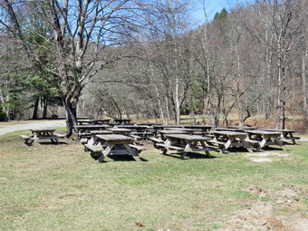 We walked along the paved road to a bathroom where we continued straight ahead to the last campsite. Where the road ends and we walked down to the edge of the river. I was careful to watch where I was walking as the water level was higher than it had been since the spring. I got pictures from different locations, angles and zooms. I stopped to take some pictures of the river especially downstream. Sheena who had been panting since almost the start of the hike got a drink from the river. I walked back up to my pack and stowed the camera. We walked back on the campsite road toward the last bathroom. Where the road split, there was a gathering of picnic tables where we stayed to the left to walk the parallel section of road back through the campsites. I did stop to take some shots of the tables which would be dispersed to campsites once the campgrounds opened. The road parallels the one we walked out on to make a sort of loop. We continued along the woods road to the maintenance building and stayed right to walk back on the woods road we had come out on. On the way back we did not see than man and his dogs. We did meet a family group of six people walking out and we said "Hello". We followed the road back to the bridge and climbed the small hill before walking through the bridge> We turned right to head back to the parking area. We went back to the car where Sheena and Cindy got in. I was going to go down to the river's edge to take some pictures of the bridge but there were some fishermen gathered there. I decided I had many other pictures of the bridge and put my camera away. We had finished hiking at 1:15 PM after hiking over 2 miles in 1 hour and 10 minutes with about 15 minutes of stopped time for pictures. The car's thermometer read 71 degrees and the skies were still blue and sunny.
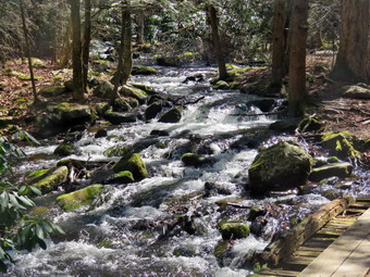
![]()
![]()
![]()
![]()
![]() On Wednesday, April 8th I planned to get on a longer hike somewhere away from Livingston Manor. I had full ambulance coverage from 8:00 AM to 4:00 PM and planned to get an early start. An overnight ambulance call cut into my sleep so I awoke in a little later than I had planned. When I got up at 9:00 AM the temperature was 36 degrees but with sunny blue skies. I decided to go to the Neversink Unique Area to hike the loop including Denton Falls and Mullet Brook Falls. I knew Cindy did not want to go but Sheena was showing she wanted to hike somewhere. I began to get ready at 10:30 AM. I got dressed in my Mammut crew top and with a long-sleeved baselayer. I put on a pair of insulated hiking pants which seemed to have no maker's label attached. The pants fit well and seemed to have just the right insulation. For boots I decided to put on my Keen Durand hiking boots which fit well. I added a new pair of Xstance insoles in an effort to find the best support and cushioning for my feet. These insoles have shock absorbing gel pads, TPU arch support, and memory foam cushioning all wrapped in a breathable fabric. The insoles have been hyped by their manufacturer and seemed to be living up to their claims. I have recently bought several brands of socks and put on a pair of OTC socks from The Buffalo Wool Company. These socks are a mixture of Merino wool and bison fiber. They have a cushioned lower and a slighty thinner upper. I put on my Baerskin fleece hoody which is a bit warmer than my Mammut hoody. I grabbed a pair of Leki Micro Vario poles I have been using for some time because they are light and lock without slipping. I chose a light hat to cover my ears and a light pair of gloves. I remembered to wear my OR Crocodile gaiters to repel any mud we might encounter. I put my gear in the back of the car and Sheena in the back seat. We left Livingston Manor at 10:40 AM as I drove east on the Quickway towards Rock Hill. I drove to Rock Hill and got off at exit 109. I turned right off the exit and drove to the parking area at the end of Katrina Falls Road. There were two vehicles parked in the lot. I parked the car and began to get ready by setting my GPS. While I was doing this, Sheena was hanging over the back seat ready to go. Sheena loves to hike and would go out everyday if she could. The temperature at the trailhead was 38 degrees. I was glad I had chosen the Mammut hoody instead of the heavier Baerskin. The wide woods road was surprisingly dry but I knew this probably would not continue as there had some rain lately. The numerous rolling rocks on the road were making walking annoying. I could hear Wolf Brook babbling as we walked down the trail which parallels the brook. We looked up to see a man and his son walking up the trail. I indicated to Sheena she should walk off trail and sit. She obeyed and I said "Hello" to the hollers. After they passed, we got back on the trail briefly when the other half of the family appeared. I again got Sheena off trail and let the Mom and daughter pass. At .5 miles we came to a yellow spur trail on the right side of the main trail. A sign indicated that this trail led to Hackeldam on the Neversink River. This was the area where a "swinging bridge" crossed the Neversink and was an important area of commerce and industry. I thought we might visit there in the way back.
On Wednesday, April 8th I planned to get on a longer hike somewhere away from Livingston Manor. I had full ambulance coverage from 8:00 AM to 4:00 PM and planned to get an early start. An overnight ambulance call cut into my sleep so I awoke in a little later than I had planned. When I got up at 9:00 AM the temperature was 36 degrees but with sunny blue skies. I decided to go to the Neversink Unique Area to hike the loop including Denton Falls and Mullet Brook Falls. I knew Cindy did not want to go but Sheena was showing she wanted to hike somewhere. I began to get ready at 10:30 AM. I got dressed in my Mammut crew top and with a long-sleeved baselayer. I put on a pair of insulated hiking pants which seemed to have no maker's label attached. The pants fit well and seemed to have just the right insulation. For boots I decided to put on my Keen Durand hiking boots which fit well. I added a new pair of Xstance insoles in an effort to find the best support and cushioning for my feet. These insoles have shock absorbing gel pads, TPU arch support, and memory foam cushioning all wrapped in a breathable fabric. The insoles have been hyped by their manufacturer and seemed to be living up to their claims. I have recently bought several brands of socks and put on a pair of OTC socks from The Buffalo Wool Company. These socks are a mixture of Merino wool and bison fiber. They have a cushioned lower and a slighty thinner upper. I put on my Baerskin fleece hoody which is a bit warmer than my Mammut hoody. I grabbed a pair of Leki Micro Vario poles I have been using for some time because they are light and lock without slipping. I chose a light hat to cover my ears and a light pair of gloves. I remembered to wear my OR Crocodile gaiters to repel any mud we might encounter. I put my gear in the back of the car and Sheena in the back seat. We left Livingston Manor at 10:40 AM as I drove east on the Quickway towards Rock Hill. I drove to Rock Hill and got off at exit 109. I turned right off the exit and drove to the parking area at the end of Katrina Falls Road. There were two vehicles parked in the lot. I parked the car and began to get ready by setting my GPS. While I was doing this, Sheena was hanging over the back seat ready to go. Sheena loves to hike and would go out everyday if she could. The temperature at the trailhead was 38 degrees. I was glad I had chosen the Mammut hoody instead of the heavier Baerskin. The wide woods road was surprisingly dry but I knew this probably would not continue as there had some rain lately. The numerous rolling rocks on the road were making walking annoying. I could hear Wolf Brook babbling as we walked down the trail which parallels the brook. We looked up to see a man and his son walking up the trail. I indicated to Sheena she should walk off trail and sit. She obeyed and I said "Hello" to the hollers. After they passed, we got back on the trail briefly when the other half of the family appeared. I again got Sheena off trail and let the Mom and daughter pass. At .5 miles we came to a yellow spur trail on the right side of the main trail. A sign indicated that this trail led to Hackeldam on the Neversink River. This was the area where a "swinging bridge" crossed the Neversink and was an important area of commerce and industry. I thought we might visit there in the way back.
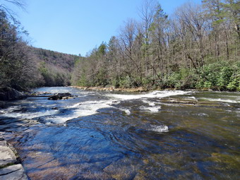 We turned left and walked down to the small bridge that crosses Wolf Brook. The bridge continues to deteriorate and is now only half as long as it once was. The stream now covered the trail from side to side beyond the bridge although the water was not very deep. I stopped to take some picture of the bridge and of the brook. The brook was flowing with a high volume which made it sound interesting as well as adding to its visual appeal. After I completed my pictures, we made our way across the bridge. I used some stepping stones to get over to the left side of the rail and then followed a trail that hikers shad created. I had to use some pieces of wood to get across another brand of the brook. Sheena just waded through the water! At the top of the hill we came to the split in the trails with the red trail going left and the blue trail heading right. There was a sign at the junction showing that the red trail to the left was the Mullet Brook Trail Loop and the Wolf Brook Access. There was a concern that people were getting lost in the Neversink Gorge due to the lack of signs and this is a welcome addition. Mileages had been posted and the sign indicated that the blue trail to the right went to Denton Falls. We stayed to the right on the blue trail which needed some trimming as the laurel was growing into the trail. The trail rolled up and down a little until we reached another yellow spur trail on the right that was labeled Old River Way. We continued straight ahead on the main blue trail. As we approached the bridge across Mullet Brook, a young man walked up from the brook to the trail. He turned left and headed back the way we came. I looked to the right to see if I wanted to take pictures but decided against it. We walked the main trail uphill to the bridge. The bridge had been replaced a few years ago after it had almost fallen into the brook. We continued across the bridge and up the hill. The next yellow spur trail on the right led down to Denton Falls and Sheena turned right and I followed her down the trail. I wanted to go to Denton Falls to see a falls on the Neversink as I expected the volume of water would be high. As we had walked along the trail to this point, I could look down to the river and saw rapids and whitecaps along the entire length.
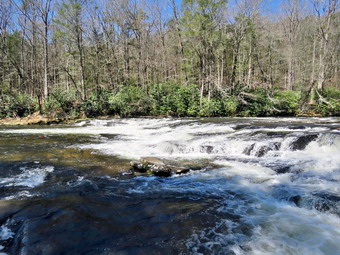 The trail up top was relatively dry as it worked its way through the laurel. We broke out of the brush and tried to find the trail. It was disappointing that the markers were still few and far between. The missing markers cause hikers to make their own paths which makes the best path unclear. When we came to the steeper section of the trail that descends to the river the markers all but disappeared but I followed Sheena WO always seems to know the location of the trail. I followed Sheena as she followed the track down to the marked trail and then turned left to parallel the river. There are always some muddy spots on this section but there were not many on this occasion and many were partly frozen. Hikers had been widening the trail to avoid the mud but this made the muddier areas even bigger! When we got to the rocks "steps" that go down to the river, I was very careful to work my way over the roots and the rocks. At the bottom of the path, we walked out on the rocks and over to a large boulder where I dropped my pack and got out the camera. The water was very high and was rapidly flowing over the rock. I took some pictures upstream and downstream with a nice blue sky, sunshine, and some white clouds. I found a way to get downstream but I was careful with my footing as I had fallen on the slippery rocks more than once. I got to a point below the falls with good footing and was surprised at how much water was going over the falls. I took pictures of the falls from several different angles and zooms. I also took shots downstream and upstream. Sheena was walking out on the exposed rocks and playing in the water. I decided I wanted some shots from the side of the falls and started back the way I came. I took some pictures from the side of the falls. I had Sheena pose for a few shots with the river, sky, and clouds in the background. We walked back up the rocks to my pack where I stowed the camera and got a drink and a bar.
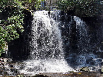 We started back up the trail and I found climbing up easier than coming down. Sheena decided to start to do some zoomies. She does not seem to care about the mud and runs through it with abandon. We continued to work our way up the bank out of the gorge. Several times I thought I was going the right way but Sheena was going another. In every case Sheena was correct! At the main blue trail, we turned right and after a shirt distance we ran into another trail junction. The blue trail continues to the right and parallels the river heading toward High Falls. The red trail turns left and heads over the hill back toward the parking area. There was a sign indicating the purpose of the red trail but none for the blue trail. I thought about going to High Falls but adding another 4 miles seemed a little too much for me. We turned left on the red trail to start the loop and to visit Mullet Brook Falls. At this point I opened all the zippers on my hoody as the temperature was rising and the hiking was making me warmer. We climbed the hill and then turned left on the yellow spur trail to Mullet Brook Falls. We arrived at the falls and found no one else there. The falls had a high volume of water that was crashing down onto the rocks below and into the plunge pool. I put my pack down and got out the camera. I headed up the rocks toward the right side of the falls. When I got to a good viewpoint, I started taking pictures of the falls from different zooms. The light proved to be almost perfect so I took quite a few shots. I decided I wanted to get in front of the falls to take some more pictures. I tried crossing over in front of the falls but found that the mist from the falls had frozen on the rocks making them extremely slippery. I walked back down the rocks and crossed a small part of the stream before walking across the rocks. I found the place I wanted directly in front of the falls and took a number of shots with different settings and zooms. While I was doing this, Sheena waited patiently for me. I again asked Sheena to pose and she walked to a rock and sat down. After taking some shots of Sheena, I took some shots of the stream below the falls. When I was done, we worked our way back to my pack. I got a drink and we headed back out the yellow trail toward the main red trail.
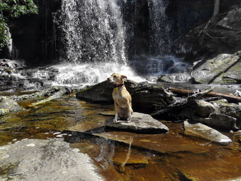 We turned left on the red trail and headed uphill which usually tires me out but felt okay on this day. For a half mile we walked uphill gaining 250 feet. We were soon at the upper bridge across Mullet Brook. The bridge was in good shape. I didn't really want to take anymore pictures so we continued on the trail. We came to the spur trail that leads to a parking area in the Wolf Brook Multiple Use Area where we turned left to stay on the red trail passing by the trail leading out to the Wolf Lake parking area. The rest of the hike was downhill except for the hill back up to the parking area. For the next .85 miles we lost 400 feet. There were no blowdowns across the trail and there were no areas where there brush encroaching on the trail. The trail was dry until we finished the descent and then there were huge puddles in the low-lying areas. We were soon back at the junction with the blue trail. We turned right and walked down the hill to cross the bridge over Wolf Brook. We turned right to follow the trail up the hill to the parking area. As we started to hike up the hill, I looked up to see two hikers headed down the trail. We said "Hello" and continued in our respective directions. When I let Sheena go, she was off like a shot up the trail toward the parking area. We continued on the trail. The steepest section of the trail was less than 10% but I was a little tired by this time. Sheena headed up the trail toward the parking area and I followed. We were back at the car at 2:15 PM after hiking 4.8 miles in 3 hours. This included the stops to take pictures. We gained about 965 feet in elevation. The temperature was 44 degrees as we left the parking lot.
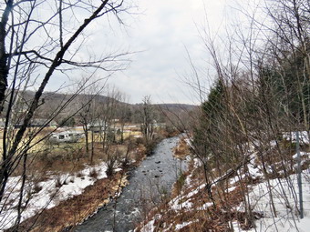
![]()
![]()
![]()
![]()
![]() On Tuesday, April 7th, I really wanted to go for a hike but the weather forecast was for snow and rain showers with overcast skies and temperatures only in the high 30s! I had not yet hiked in April and thought this would be a good day to start as I had full ambulance coverage for the day. I knew Sheena would be excited as it had been a week since our last walk because of the weather, numerous ambulance calls and church commitments. There was enough snow to cover the ground in the morning but it quickly melted. I did some work around the house and then decided OT was time to make a decision. I decided to hike the Parksville Rail Trail as we could turn around at any time it Sheena was too cold. As we began to get ready at 11:45 AM the temperature on the back porch was 38 degrees but the skies were still overcast. I assumed most of the snow would be gone but I planned to take my spikes anyway. Sheena loves warm places and has a short coat but also seems to really like the snow. The Parksville Rail Trail is under three miles out and back but keeping a quick pace helps increase the difficulty as does the snow and ice. Sheena actually does get in about twice the mileage that I do as she forges ahead and then comes back! I have transitioned from using a leash all the time to using a GarmimSport PRO electronic collar which has many versatile settings and seems to do the job. This allows Sheena to roam and keeps me sane by not having to yank on her leash. It seems that Sheena likes hiking as she smells my clothes and then runs to sit by the door or wanders around my study watching me get dressed! On this day she could hardly contain herself! I got dressed in my Mammut crew shirt with a long-sleeved baselayer. I put on a pair of insulated hiking pants which seemed to have no maker's label attached. The pants fit well and seemed to have just the right insulation. For boots I decided to put on my Keen Durand hiking boots which fit well. I added a new pair of Xstance insoles in an effort to find the best support and cushioning for my feet. These insoles have shock absorbing gel pads, TPU arch support, and memory foam cushioning all wrapped in a breathable fabric. The insoles have been hyped by their manufacturer and seemed to be living up to their claims. I have recently bought several brands of socks and put on a pair of OTC socks from The Buffalo Wool Company. These socks are a mixture of Merino wool and bison fiber. They have a cushioned lower and a slighty thinner upper. I put on my Baerskin fleece hoody which is a bit warmer than my Mammut hoody. I grabbed a pair of Leki Micro Vario poles I have been using for some time because they are light and lock without slipping. I chose a light hat to cover my ears and a light pair of gloves. I remembered to wear my OR Crocodile gaiters to repel any mud we might encounter. I decided to take my pack as I could carry my camera and it added a little difficulty to an otherwise easy trail. As we walked out to the car just after noon, the sky was still overcast. I put my gear in the back of the car and Sheena in the back seat and left Livingston Manor at 12:05 PM. I drove out Old Route 17 toward Parksville and turned left under the Quickway overpass onto Service Road. I drove toward Parksville and pulled into the parking area on the right side of the road just after Fox Mountain Rd. There were no cars parked in the lot when we arrived. I got out of the car and checked the trail to find the trail was completely clear of snow and ice. I made sure Sheena's ecollar was adjusted correctly and let her out of the car. When I opened the car door, Sheena came out like a shot and headed for the trail. We started on our hike at 12:17 PM with the temperature at 36 degrees. There were a few flakes in the air and the wind was blowing at a stiff 20 mph.
On Tuesday, April 7th, I really wanted to go for a hike but the weather forecast was for snow and rain showers with overcast skies and temperatures only in the high 30s! I had not yet hiked in April and thought this would be a good day to start as I had full ambulance coverage for the day. I knew Sheena would be excited as it had been a week since our last walk because of the weather, numerous ambulance calls and church commitments. There was enough snow to cover the ground in the morning but it quickly melted. I did some work around the house and then decided OT was time to make a decision. I decided to hike the Parksville Rail Trail as we could turn around at any time it Sheena was too cold. As we began to get ready at 11:45 AM the temperature on the back porch was 38 degrees but the skies were still overcast. I assumed most of the snow would be gone but I planned to take my spikes anyway. Sheena loves warm places and has a short coat but also seems to really like the snow. The Parksville Rail Trail is under three miles out and back but keeping a quick pace helps increase the difficulty as does the snow and ice. Sheena actually does get in about twice the mileage that I do as she forges ahead and then comes back! I have transitioned from using a leash all the time to using a GarmimSport PRO electronic collar which has many versatile settings and seems to do the job. This allows Sheena to roam and keeps me sane by not having to yank on her leash. It seems that Sheena likes hiking as she smells my clothes and then runs to sit by the door or wanders around my study watching me get dressed! On this day she could hardly contain herself! I got dressed in my Mammut crew shirt with a long-sleeved baselayer. I put on a pair of insulated hiking pants which seemed to have no maker's label attached. The pants fit well and seemed to have just the right insulation. For boots I decided to put on my Keen Durand hiking boots which fit well. I added a new pair of Xstance insoles in an effort to find the best support and cushioning for my feet. These insoles have shock absorbing gel pads, TPU arch support, and memory foam cushioning all wrapped in a breathable fabric. The insoles have been hyped by their manufacturer and seemed to be living up to their claims. I have recently bought several brands of socks and put on a pair of OTC socks from The Buffalo Wool Company. These socks are a mixture of Merino wool and bison fiber. They have a cushioned lower and a slighty thinner upper. I put on my Baerskin fleece hoody which is a bit warmer than my Mammut hoody. I grabbed a pair of Leki Micro Vario poles I have been using for some time because they are light and lock without slipping. I chose a light hat to cover my ears and a light pair of gloves. I remembered to wear my OR Crocodile gaiters to repel any mud we might encounter. I decided to take my pack as I could carry my camera and it added a little difficulty to an otherwise easy trail. As we walked out to the car just after noon, the sky was still overcast. I put my gear in the back of the car and Sheena in the back seat and left Livingston Manor at 12:05 PM. I drove out Old Route 17 toward Parksville and turned left under the Quickway overpass onto Service Road. I drove toward Parksville and pulled into the parking area on the right side of the road just after Fox Mountain Rd. There were no cars parked in the lot when we arrived. I got out of the car and checked the trail to find the trail was completely clear of snow and ice. I made sure Sheena's ecollar was adjusted correctly and let her out of the car. When I opened the car door, Sheena came out like a shot and headed for the trail. We started on our hike at 12:17 PM with the temperature at 36 degrees. There were a few flakes in the air and the wind was blowing at a stiff 20 mph.
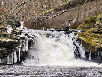 The trail was bare and only slightly damp at the beginning but I wondered what it would look like in the shade of the trees. It was a pleasure to be able to walk without worrying about getting a good place to plant your feet. Off her leash Sheena runs ahead of us a certain distance and then maintains that distance by waiting or increasing her pace. On this day she seemed to be very interested in the many game trails that had been under the snow. We were soon under the cover of the trees and the trail remand completely devoid of snow and ice. The usual spots had some standing water and mud but for the most part they were easy to avoid cross. Sheena was enjoying the freedom of the hike and the various game tracks. She did not seem cold as she had on some previous hikes. I was happy I wore the Baerskin hoody as it is warm and blocks the wind well. The trail runs parallel to the Little Beaverkill and the new section of State Route 17. It follows the route of the O&W railroad and is very flat. Sheena was setting a quick pace and I didn't mind as long as she would listen and wait for me when necessary. The wind was perpendicular to the trail and I didn't notice it much except in the more open spaces. The biggest change in the trail conditions from my previous hikes was the mud pits that had opened up and the standing water on parts of the trail. This continued for much of the hike. I noticed that the noise from the stream was a roar and several views showed the water was high and running rapidly. We came to the viewpoint just before the wooden walkways which has a nice view down to the stream. I took a peek and did not notice anything much different than the last trip. We walked across the wooden walkways which were still slippery even without a ridge of ice. The area before the bridge had running water and more water was passing under the bridge. There was a large patch of mud after the bridge.
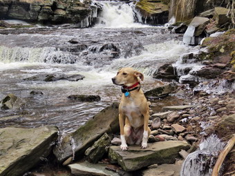 We came to the landslide that had brought down several trees that had been cut and cleared. This area also had open water and a lot of mud. We negotiated this area and continued toward the falls. As we approached the falls there was a significant increase in noise from the stream. The falls came into view at 12:37 PM after only 20 minutes of hiking. The water level was about the same as out last trip but there was no snow or ice around the area of the falls. We continued onward to the Parksville end of the trail. The remainder of the walk to the other end of the trail went quickly. Sheena took the lead which she sometimes is reluctant to do as there are sometimes dogs at the end of the trail. The large dog across the stream was absent. As we approached the end of the trail, the dogs that are usually outside barking were nowhere to be found! We tagged the end of the trail at 12:27 PM meaning it had taken us only 27 minutes to hike. We turned around to head back to the car. It seemed the temperature had stayed the same and that the wind was still blowing. We walked quickly back toward the car with Sheena in the lead continuing to wander off trail. Sheena seemed fine and was not favoring any of her paws because of the cold. Within 7 minutes we passed by the falls and continued to push the pace. We soon came to the bridge and the walkways, where we carefully walked over the slippery surface. As we approached the end of the trail, Sheena decided to let off some more energy by executing a set of zoomies. I eventually called her and told her "With" which is the equivalent of "Heel". We arrived back at the car at 1:09 PM after hiking 3 miles in 52 minutes! The return trip was faster than the trip out by two minutes. The temperature was still 37 degrees and the wind was still blowing but the sun was beginning to show through. Sheena seemed fresh and I felt she could have hiked out and back on the trail another time. When we returned home, there had been an ambulance call which the crew covered.
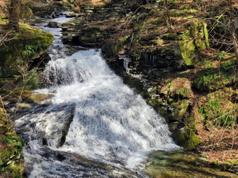
![]()
![]()
![]()
![]()
![]() On Monday, March 30th I had coverage for ambulance calls from 8:00 AM to 3:00 PM. I planned to get out for a hike somewhere that I had not been in some time. I decided I wanted to take Sheena and go to the area around Trout Pond. This is an area I have hiked many times but I had not been there in some time. As usual I got some extra sleep in the morning and got up at 9:00 AM. I had a text from my EMT that said she would not be available until 11:00 AM but that coincided with the forecast for temperatures in the high 50's. I started to get ready at 10:45 AM with the temperatures at 56 degrees on the back porch. Sheena is a Feist-Cur cross which are actual types of dogs used on farms and for hunting in the south. She loves to get out and hike. Even though she is only not quite 2 years old she is very strong for a small dog. I am glad that I have transitioned to an ecollar and that Sheena has learned basic commands very quickly. On this day Sheena was hanging out near me so that I would not forget to take her. I got dressed in my Mammut crew shirt with a long-sleeved baselayer. I put on a pair of insulated hiking pants which seemed to have no maker's label attached. The pants fit well and seemed to have just the right insulation. For boots I decided to put on my Keen Durand hiking boots which fit well. I added a new pair of Xstance insoles in an effort to find the best support and cushioning for my feet. These insoles have shock absorbing gel pads, TPU arch support, and memory foam cushioning all wrapped in a breathable fabric. The insoles have been hyped by their manufacturer and seemed to be living up to their claims. The only problem with these insoles is that they are high volume which leaves less room for my feet! I have recently bought several brands of socks and decided to wear a light pair of socks from EcoSox which are knit from bamboo fiber. These socks are warm enough but thin and very soft. I put on my Mammut hoody which has a lot of zippers to dump heat when needed. I grabbed a pair of Leki Micro Vario poles I have been using for some time because they are light and lock without slipping. I chose a light hat to cover my ears and a light pair of gloves. I decided to put on my OR Crocodile gaiters to repel any water or mud that might be on the trail. I put my gear in the back of the car and left Livingston Manor at 11:00 AM.
On Monday, March 30th I had coverage for ambulance calls from 8:00 AM to 3:00 PM. I planned to get out for a hike somewhere that I had not been in some time. I decided I wanted to take Sheena and go to the area around Trout Pond. This is an area I have hiked many times but I had not been there in some time. As usual I got some extra sleep in the morning and got up at 9:00 AM. I had a text from my EMT that said she would not be available until 11:00 AM but that coincided with the forecast for temperatures in the high 50's. I started to get ready at 10:45 AM with the temperatures at 56 degrees on the back porch. Sheena is a Feist-Cur cross which are actual types of dogs used on farms and for hunting in the south. She loves to get out and hike. Even though she is only not quite 2 years old she is very strong for a small dog. I am glad that I have transitioned to an ecollar and that Sheena has learned basic commands very quickly. On this day Sheena was hanging out near me so that I would not forget to take her. I got dressed in my Mammut crew shirt with a long-sleeved baselayer. I put on a pair of insulated hiking pants which seemed to have no maker's label attached. The pants fit well and seemed to have just the right insulation. For boots I decided to put on my Keen Durand hiking boots which fit well. I added a new pair of Xstance insoles in an effort to find the best support and cushioning for my feet. These insoles have shock absorbing gel pads, TPU arch support, and memory foam cushioning all wrapped in a breathable fabric. The insoles have been hyped by their manufacturer and seemed to be living up to their claims. The only problem with these insoles is that they are high volume which leaves less room for my feet! I have recently bought several brands of socks and decided to wear a light pair of socks from EcoSox which are knit from bamboo fiber. These socks are warm enough but thin and very soft. I put on my Mammut hoody which has a lot of zippers to dump heat when needed. I grabbed a pair of Leki Micro Vario poles I have been using for some time because they are light and lock without slipping. I chose a light hat to cover my ears and a light pair of gloves. I decided to put on my OR Crocodile gaiters to repel any water or mud that might be on the trail. I put my gear in the back of the car and left Livingston Manor at 11:00 AM.
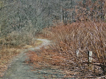 I drove north on the Quickway towards Roscoe and got off at exit 94 heading north on Route 206 towards Downsville. After crossing the Rockland Flats and passing the Roscoe Nursing Home, I turned left on Morton Hill Road and drove to the intersection with Russell Brook Road. There were no cars sitting in the "lot" at the intersection of the two roads. People see the open space and park there without thinking about the fact that the land is private. I did not want to have to walk back up Russell Brook Road at the end of the hike so I decided to drive down the road to park in the lower lot. I knew that the road might be muddy and soft and that there could be blowdowns. There was one blowdown that someone had cut and the road surface was firm. I parked by the small pulloff above the upper falls as I could see there was a lot of water and the lighting was perfect. I retrieved my camera from the pack and opened the doer for Sheena to get our. For some reasons, Sheena refused to get out so I closed the door and walked down the steep bank to a viewpoint above the falls. I took a number of pictures with different zooms and angles. I moved to another spot and took some more shots. When I finished, I returned to the car and stowed the camera. I drove down to the lower parking lot and parked the car in the lot where two other cars were parked. A group of four people were gathered around one of the cars and they soon got in and left. Russell Brook Falls is popular as a falls and swimming area and people also like to camp at Trout Pond. It was very early in the season and it was a weekday so I was not surprised that there were so few people. My intention was to visit the falls on the way out as the lighting was best that way. I had brought my GPS unit even though we had done the hike before as I wanted to see how long and how fast we would go. We started our hike by turning on the electronic collar on Sheena and the remote in my pocket. When I let Sheena out of the car she started running around the parking area sniffing everything in sight. At 11L40 AM we started our hike by walking down the woods road toward the bridge across Russell Brook. The road was mostly dry with a few damp spots.
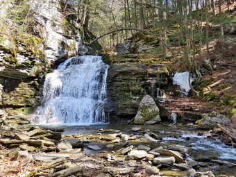 As we crossed the bridge, we ran into a patch of ice which was easily avoided. I could see that the water in the brook was high and there were small rapids in several places. The Japanese knotweed was knocked down and all brown although some was encroaching on the trail. I used to cut back the knotweed but it is the responsibility of the DEC and they seldom bother. I stopped to take a few shots of the knotweed to contrast the condition now with what it looks like in full bloom. The history of this area is very interesting. Russell Brook Falls had been the site of a dam that impounded water for a waterwheel in Butternut Grove. The wheel was still there a few years ago. The area near the register box was the "landing zone" for loggers who cleared the evergreen trees, not for tanning but, for the production of wood alcohol. The trees were transported on narrow gauge railway that ran parallel to Russell Brook. The railway met the mainline O&W near Butternut Grove where the logs were unloaded. There were several acid factories in the area that produced wood alcohol. There was also a factory on the lower part of Russell Brook that produced khaki dye for the uniforms of American troops during World War I. We continued on the trail to the first junction where we turned right. When we came to the path to the falls we turned right and walked toward the falls. Someone had beaten the knotweed back along this path. We walked to the spot where the path descends to the streambed. We walked down to the bottom and to the streambed. I was glad there were no people present. The falls had as much water as I have seen flowing over them and the lighting was great. I put down my pack and got out my camera and took some pictures of the falls at different angles and zooms. I also took shots of the stream. I remembered how Sheila would pose in front of the falls while I took pictures of her. I got Sheena to pose by the falls and took a few shots. She is getting very good at posing and staying until I call her. I looked up at the cliffs that surround the falls and realized that two hikers were on the upper trail looking down at the falls! I returned to my pack and put away the camera. We walked back up to the path that runs out to the main trail. I had some time constraints and decided not to go up to the top of the falls.
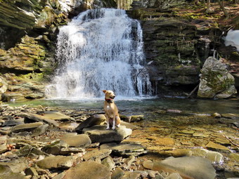 At the main trail we turned right and followed the main trail passed the register box and up the trail toward Trout Pond. Sheena had headed to the left but was quick to see where I was headed and raced ahead of me. The trail was wet but not really muddy. All of the small streams that cross the trail were flowing freely. I did notice that several blowdowns had been cut and cleared from the trail using a chainsaw. These trails are maintained by the DEC and the frequency that they are maintained is spotty and usually occurs once in the spring. We continued on the trail uphill toward Trout Pond. I wasn't consciously pushing the pace but the walk seemed to go very quickly as we passed the path to the first primitive campsite on the left. My breathing and heart rate were up but it felt good. Sheena was leading the way but keeping a consistent distance ahead of me. She did come back to visit several times! I could hear the outlet stream from Trout Pond and it indicated a high volume of water. Sheena was ahead of me on the trail with an occasional trip off trail. Giving her the command "Trail" brought here right back. When she is on the trail, she picks a certain distance ahead of me and maintains that distance by waiting for me or speeding up. Soon we were at the outlet end of the pond and we walked to the beach which had a narrow band of exposed sand. I put my pack down to get out my camera and while I was doing that I heard splashing as Sheena was doing some wading in the water which still had a skim of ice! The skies were blue with wispy white clouds. The sun was shining but would not interfere with photography as it was behind me. Water was pouring over the spillway which still had some ice. There were also several patches of snow where the winds had caused drifts during the winter. I made sure to get shots of the pond and the blue sky with the clouds. I also some of the beach and the spillway. I remembered times when I was there with Sheila and she would swim to retrieve sticks or wade to cool off. Sheena posed at the edge of the pond and I took some pictures. I packed up and we returned to the main trail to walk the flat woods road toward the inlet end of the pond.
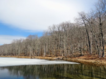 This trail is always wet but on this day the water was easy to avoid. I kept looking back to see if the other hikers had followed us but we never saw them again. Sheena kept walking over to the edge of the water looking like she might jump in again. A duck or two skimmed the water and I thought that would be the signal for her to get wet but she restrained herself. The small stream just before the trail junction near the leanto was flowing but the volume was less than I would have expected. When we came to the bridge, I stopped to take a few pictures of the pond from the bridge. The inlet stream was flowing nicely and the sun sparkled on the surface. Sheena was doing zoomies around the trails and paths. I got her to sit still long enough that I could take some pictures of her on the bridge. At the start of the hike I questioned whether I would feel like continuing around the pond as there is a pretty good climb. I was feeling great and decided to continue. We crossed the bridge and stayed to the right on the Mud Pond Trail which would take us over Cherry Ridge and form a loop back to the parking area. The trail was relatively dry but very rocky as we started to ascend the hill. As we continued up the trail, I slowed a little as the grade increased. I had not been hiking many hills much lately and I felt it. We began to run into places where branches, small trees, and large trees had been cut and removed from the trail. These trails are maintained by the DEC but I was not sure when the work had been done. There were also a few new blowdowns that had not been cleared from the high winds that had blown through the area in the passed few weeks.
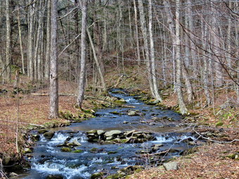 From the bridge at the inlet we climbed 430 feet over the next .75 miles. The trail headed west from the inlet until turning sharply south at around 2 miles. The highest point on the trail was at 2.2 miles after which most of the rest of the hike is downhill. I was not surprised that I was getting tired on the climb but I still felt great. As we started down the other side, there were more and more place where there was standing or running water on and across the trails. I was able to avoid the water in most of these areas but Sheena simply walked through it. These conditions continued for the rest of the trip. We ascended a the hill to the stand of small birch trees and then descended the other side. At 3.4 miles we had descended 420 feet from Cherry Ridge to the snowmobile trail near Mud Pond. I could see that the trail was damp so we stayed on the woods road. I considered walking over to Mud Pond but I was a little later than I wanted. We ascended a small hill before starting downhill back toward the parking area. As usual this section had some running water across it and some running down the trail. This part of the trail is exceptionally rocky making the descent tricky. Even though I was being careful there were times I was very glad I had the poles! The small stream near the bottom of the hill was flowing but was easily crossed. We passed the large campsite on the left and came to the bridge over the outlet stream For Trout Pond. All told, we had dropped 380 feet over the .7 miles back to the bridge. I crossed the bridge over the outlet stream which had a good volume of water flowing. The light was so nice I decided to stop and take a few shots. When I was done, we continued to the main Trout Pond Trail where we turned right. We continued on the trail passing the knotweed. We crossed the bridge and walked up the trail to the parking area. I had been thinking about calling the Stamford DEC to report the blowdowns. I was surprised but happy to see a ranger at his truck on the other side of the gate. I said "Hello" and explained what I had seen. He got out a pad and took down the information and promised to relay it to the Operations Division. I thanked him and we walked back to the car. We were back at the car at 2:30 PM and had hiked 4.7 miles in 2 hours and 50 minutes with an elevation gain of 925 feet. We had stopped 25 minutes for pictures. My moving speed was just under 2 mph but I was satisfied because of the rolling terrain. There were now no cars in the lot and we had met no other hikers on the trail.
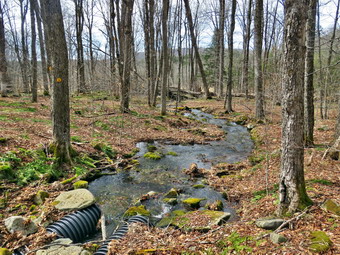
![]()
![]()
![]()
![]()
![]() On Thursday, March 26th, I was ready to get out and hike for the second time this week. I had ambulance coverage from 8:00 AM to 2:00 PM and thought about getting out by 8:00 AM for a longer hike somewhere close. Several call overnight changed that thought and I finally got up at 9:00 AM. I was till tired but the forecast was for sun and warm temperatures until late afternoon when there might be showers. I started to get ready at 10:30 AM when the temperature was 56 on the back porch. As I started gathering my equipment and getting dressed, Sheena was very quiet but did not let me out of her sight. I got dressed in my Mammut crew shirt with a long-sleeved baselayer. I put on a pair of insulated hiking pants which seemed to have no maker's label attached. The pants fit well and seemed to have just the right insulation. For boots I decided to put on my Keen Durand hiking boots which fit well. I added a new pair of Xstance insoles in an effort to find the best support and cushioning for my feet. These insoles have shock absorbing gel pads, TPU arch support, and memory foam cushioning all wrapped in a breathable fabric. The insoles have been hyped by their manufacturer and seemed to be living up to their claims. The only problem with these insoles is that they are high volume which leaves less room for my feet! I have recently bought several brands of socks and put on a pair of OTC socks from The Buffalo Wool Company. These socks are a mixture of Merino wool and bison fiber. They have a cushioned lower and a slighty thinner upper. I put on my Mammut hoody which has a lot of zippers to dump heat when needed. I grabbed a pair of Leki Micro Vario poles I have been using for some time because they are light and lock without slipping. I chose a light hat to cover my ears and a light pair of gloves. I meant to wear my OR Crocodile gaiters to repel any snow or mud but somehow forgot them! I decided to take my pack as I could carry my camera and it added a little difficulty to an otherwise easy trail. I also thought there might be good photographic opportunities. I put the ecollar on Sheena and turned it on. This time I remembered the controller in my pocket. I got our gear and Sheena in my car and left Livingston Manor at 11:00 AM.
On Thursday, March 26th, I was ready to get out and hike for the second time this week. I had ambulance coverage from 8:00 AM to 2:00 PM and thought about getting out by 8:00 AM for a longer hike somewhere close. Several call overnight changed that thought and I finally got up at 9:00 AM. I was till tired but the forecast was for sun and warm temperatures until late afternoon when there might be showers. I started to get ready at 10:30 AM when the temperature was 56 on the back porch. As I started gathering my equipment and getting dressed, Sheena was very quiet but did not let me out of her sight. I got dressed in my Mammut crew shirt with a long-sleeved baselayer. I put on a pair of insulated hiking pants which seemed to have no maker's label attached. The pants fit well and seemed to have just the right insulation. For boots I decided to put on my Keen Durand hiking boots which fit well. I added a new pair of Xstance insoles in an effort to find the best support and cushioning for my feet. These insoles have shock absorbing gel pads, TPU arch support, and memory foam cushioning all wrapped in a breathable fabric. The insoles have been hyped by their manufacturer and seemed to be living up to their claims. The only problem with these insoles is that they are high volume which leaves less room for my feet! I have recently bought several brands of socks and put on a pair of OTC socks from The Buffalo Wool Company. These socks are a mixture of Merino wool and bison fiber. They have a cushioned lower and a slighty thinner upper. I put on my Mammut hoody which has a lot of zippers to dump heat when needed. I grabbed a pair of Leki Micro Vario poles I have been using for some time because they are light and lock without slipping. I chose a light hat to cover my ears and a light pair of gloves. I meant to wear my OR Crocodile gaiters to repel any snow or mud but somehow forgot them! I decided to take my pack as I could carry my camera and it added a little difficulty to an otherwise easy trail. I also thought there might be good photographic opportunities. I put the ecollar on Sheena and turned it on. This time I remembered the controller in my pocket. I got our gear and Sheena in my car and left Livingston Manor at 11:00 AM.
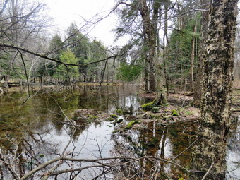 I drove out the DeBruce Road about 6 miles to Mongaup Road and turned left to continue up the road to the point where it splits. I stayed left on Beech Mountain Road and drove to the Frick Pond trailhead. When we arrived at the parking areas, there were no cars parked in the other lot. I pulled into the smaller lot and parked. The skies were completely bright and blue and there were a few clouds. I set my GPS unit and we started out the woods road to the Quick Lake Trail at the register. The trail was very wet with standing and running water everywhere. The base of the trail was also soft and muddy. It was relatively easy to avoid the mud by picking my steps carefully. Sheena just walked straight ahead on the trail ignoring the mud and the water. At Gravestone Junction, we passed by the memorial stone for two young children from the Lobbdell family who died when their cabin caught fire in the 1930's. We turned right on the Logger's Loop Trail to do a counterclockwise loop heading toward Times Square. I noted the new signs marking the trail junction with full information and the correct mileage. It wasn't long before we came to the primitive campsites to the left of the trail and two blowdowns blocking the trail. These two trees have been across the trail for months and no one has addressed them. When individual maintainers were working on the trails they would have been gone in less than a week! The NYNJTC decided to eliminate individual maintainers and trail supervisors in favor of roving trail crews. The result in this area has not been good. After a flurry of activity, it is obvious that the crew had not returned to maintain the area. This is a shame as the former maintainers always tried to keep the loop around Frick Pond in good shape as so many people are introduced to hiking on these trails. Hikers had made paths around the blowdowns or had simply stepped over them. The rest of the trail was largely clear but it was wet and muddy in spots. The walk to Times Square is mostly downhill which we enjoyed. Sheena was out ahead following her nose and venturing if the trail in places. A whistle or a "Not too far' bring her right back to me every time. Just before Times Square, a small stream crossed the trail. The stream is usually dry but on this day it was freely flowing with some small rills. I stopped to take some pictures of the stream in both directions.
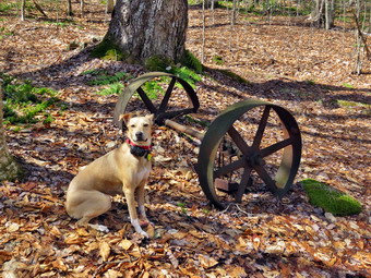 We continued on the trail and at Times Square we continued straight ahead on the Logger's Loop which was very wet and muddy. There are many surface springs and runoff from the melting snow had headed downhill to Times Square. We started a slight uphill climb on the trail but the hiking was relatively easy. The trail flattened and we came to the small, seasonal "pond" on the right side of the trail. The pond was as full as I have ever seen it and I could here the sound of peepers. I worked my way to the other side of the pond on the trail and put down my pack. I took pictures of the trail with some snow and then turned my attentions to the larger pond. I walked into the woods and found a good viewpoint. I took some host to record the appearance of the Lind when full as in Te summer it is often a field of ferns. We continued on the trail and I noted several large plastic culverts along the way. The DEC has started a project to replace the metal culverts and to install culverts were they were needed but did not exist. That project began at least six years ago but was not completed and the black culverts stand out like a sore thumb. The rest of the Loggers Loop to Iron Wheel Junction had wide and deep ponds spanning the trail. There were also large mud pits. We came to a large culvert that directs a substantial stream underneath the trail and there was a large volume of water in the stream. We continued on the trail and it wasn't long before we were walking downhill and the climbing a small hill to Iron Wheel Junction. We stopped at the trail junction so I could take some pictures of the wheels that give the junction its name. Sheena posed for some pictures before we turned left and headed back toward Frick Pond on the Quick Lake Trail. The trail is slightly downhill which allowed us to keep up a good pace. The only drawback was that there were many wet and muddy places that slowed us slightly! When we came to the small stream in the woods, we found the water level very high. There was a lot of snow in the woods and covering the trail. In some areas the snow was 6 inches deep! I took some pictures of the area before I crossed including some of the small waterfall upstream. I turned my attention to crossing the stream. Sheena simply jumped over the stream with no problem. I decided to use the stepping stone which were partly submerged. This proved to be a good move and only the soles of my shoes got wet.
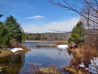 We walked through the snow on the other side and the through the "spruce tunnel" where it was damp. Eventually we walked out the other side where the trail was again very wet and muddy. We came to two more blowdowns blocking the trail. It had been there so long that hikers had created detours around them! We continued on the trail and arrived at the junction with the Big Rock Trail where we turned right to stay on the Quick Lake Trail. We headed toward the bridge at the outlet end of Frick Pond. The trail was covered in snow as the show from the pond drifts to this side of the pond. We continued on the Quick Lake Trail to the bridge across the outlet of Frick Pond where there was a great deal of snow. We crossed the bridge and stopped at the other side. There were some ducks on the pond and I wanted to get pictures. Sheena was very quiet and did not bark or approach the water. I dropped my pack to get out the camera despite the fact that I have taken hundreds of pictures from this location. I immediately took pictures of the ducks as they swam away from us. The skies were blue and there was sun even though earlier there was some overcast.I also took shots of the pond and of Beech Mountain. I had Sheena pose on the bridge and made sure I took pictures of her and the snow. I packed up and we continued up the hill and back toward Gravestone Junction. At the top of the hill we saw a young woman with her dog on a leash coming toward us. I guided Sheena off the trail as they approached. As she passed we exchanged greetings and compliments on each other's dogs. Sheena was straining to get on the trail and head in the opposite direction of the other dog! This section of trail was also wet with mud. At Gravestone Junction we continued out the Quick Lake Trail and back to the car. We arrived at the car at 1:23 PM having hiked 3.8 miles in 2 hours and 5 minutes with an elevation gain of 350 feet. Our time stopped was 15 minutes most of which was time spent taking pictures. Our moving speed was 2.1 MPH. The temperature had risen to 65 degrees which was higher than the forecast.
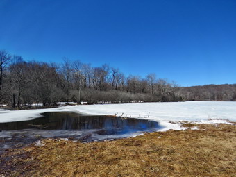
![]()
![]()
![]()
![]()
![]() On Tuesday, March 24th I had coverage for ambulance calls from 6:00 AM to 6:00 PM for the first time in a long time. I wanted to get out for a hike of at least 6 miles with some interesting points along the way. I thought about Trout Pond and Russell Brook Falls but did not know whether the road would be icy or not. I decided to go to the Frick Pond area and hike up the Flynn Trail to Hodge Pond. At that point I could choose to complete the long loop back to Frick Pond, return by way of the Flynn Trail, or several other variations. When I got up in the morning I had a text from Lisa Lyons asking if I would like to hike on Round Top. I told her my plans and we agreed to meet at my house and take one car to Frick Pond. I don't like to do this as it then binds us together to do the same hike but taking one care seemed more economical. I began to bet ready at 11:30 AM with the temperature at 44 degrees on the back porch and plenty of sun and blue skies. Sheena loves warm places and although she doesn't mind the snow I knew the warmer weather would be more to her liking. Sheena actually does get in about twice the mileage that I do as she forges ahead and then comes back! I have transitioned from using a leash all the time to using a GarmimSport PRO electronic collar which has many versatile settings and seems to do the job. This allows Sheena to roam and keeps me sane by not having to yank on her leash. It seems that Sheena likes hiking as she smells my clothes and then runs to sit by the door or wanders around my study watching me get dressed! On this day she could hardly contain herself! I got dressed in my Mammut crew shirt with a long-sleeved baselayer. I put on a pair of insulated hiking pants which seemed to have no maker's label attached. The pants fit well and seemed to have just the right insulation. For boots I decided to put on my Keen Durand hiking boots which fit well. I added a new pair of Xstance insoles in an effort to find the best support and cushioning for my feet. These insoles have shock absorbing gel pads, TPU arch support, and memory foam cushioning all wrapped in a breathable fabric. The insoles have been hyped by their manufacturer and seemed to be living up to their claims. The only problem with these insoles is that they are high volume which leaves less room for my feet! I have recently bought several brands of socks and put on a pair of OTC socks from The Buffalo Wool Company. These socks are a mixture of Merino wool and bison fiber. They have a cushioned lower and a slighty thinner upper. I put on my Mammut hoody which has a lot of zippers to dump heat when needed. I grabbed a pair of Leki Micro Vario poles I have been using for some time because they are light and lock without slipping. I chose a light hat to cover my ears and a light pair of gloves. I remembered to wear my OR Crocodile gaiters to repel any snow or mud. I decided to take my pack as I could carry my camera and it added a little difficulty to an otherwise easy trail. I also thought there might be good photographic opportunities.
On Tuesday, March 24th I had coverage for ambulance calls from 6:00 AM to 6:00 PM for the first time in a long time. I wanted to get out for a hike of at least 6 miles with some interesting points along the way. I thought about Trout Pond and Russell Brook Falls but did not know whether the road would be icy or not. I decided to go to the Frick Pond area and hike up the Flynn Trail to Hodge Pond. At that point I could choose to complete the long loop back to Frick Pond, return by way of the Flynn Trail, or several other variations. When I got up in the morning I had a text from Lisa Lyons asking if I would like to hike on Round Top. I told her my plans and we agreed to meet at my house and take one car to Frick Pond. I don't like to do this as it then binds us together to do the same hike but taking one care seemed more economical. I began to bet ready at 11:30 AM with the temperature at 44 degrees on the back porch and plenty of sun and blue skies. Sheena loves warm places and although she doesn't mind the snow I knew the warmer weather would be more to her liking. Sheena actually does get in about twice the mileage that I do as she forges ahead and then comes back! I have transitioned from using a leash all the time to using a GarmimSport PRO electronic collar which has many versatile settings and seems to do the job. This allows Sheena to roam and keeps me sane by not having to yank on her leash. It seems that Sheena likes hiking as she smells my clothes and then runs to sit by the door or wanders around my study watching me get dressed! On this day she could hardly contain herself! I got dressed in my Mammut crew shirt with a long-sleeved baselayer. I put on a pair of insulated hiking pants which seemed to have no maker's label attached. The pants fit well and seemed to have just the right insulation. For boots I decided to put on my Keen Durand hiking boots which fit well. I added a new pair of Xstance insoles in an effort to find the best support and cushioning for my feet. These insoles have shock absorbing gel pads, TPU arch support, and memory foam cushioning all wrapped in a breathable fabric. The insoles have been hyped by their manufacturer and seemed to be living up to their claims. The only problem with these insoles is that they are high volume which leaves less room for my feet! I have recently bought several brands of socks and put on a pair of OTC socks from The Buffalo Wool Company. These socks are a mixture of Merino wool and bison fiber. They have a cushioned lower and a slighty thinner upper. I put on my Mammut hoody which has a lot of zippers to dump heat when needed. I grabbed a pair of Leki Micro Vario poles I have been using for some time because they are light and lock without slipping. I chose a light hat to cover my ears and a light pair of gloves. I remembered to wear my OR Crocodile gaiters to repel any snow or mud. I decided to take my pack as I could carry my camera and it added a little difficulty to an otherwise easy trail. I also thought there might be good photographic opportunities.
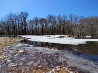 I put my gear in the car and Sheena in the back seat and wait fro Lisa to arrive. She drove into the driveway just before noon. We put her gear in the back and I drove out the Debruce Road about 6 miles. I turned left onto Mongaup Pond Road and continued to where the road split. At the split, I turned left onto Beech Mountain Road, and drove to the parking areas at the Frick Pond. There was one car in each lot as I pulled into the smaller area. The thermometer read 42 degrees as I set my GPS but the sun was out and it seemed warmer. At 12:20 PM we started our hike by crossing the road to start out on the Flynn Trail. Lisa let me know that I had said we were going to Frick Pond and that she had an important phone call at 3:00 PM. I told he I thought we could make it to Hodge and back in that time. I felt I was making a concession as I had planned to hike 3 to 4 hours! The erosion at the beginning of the trail gets worse each time it rains but I do not know how to fix the problem. The trail to the woods road toward Hodge Pond was slightly damp with a few small patches of snow. We continued along the trail beginning our conversation that soul last for the entire hike. We turned right at the end of the trail and started up the road. We passed the large spruce where Cindy and I had cut a tunnel. The DEC crew had been through and removed the tree. I was winded as we started to gain elevation as I had not been hiking very far and almost flat. I hoped I would get more accustomed as the hike continued. Talking to Lisa and listening made the hike go quickly as we continued toward Hodge Pond. At 1 miles we passed by the path to the clearing to the right of the trail. I thought about taking the detour but decided our time constraints made this a plan for another day. We descended a little bit and then began a gentle climb to the junction with the Big Rock Trail. The slope of the trail moderates some in this area and I noticed my breathing was better. We reached the trail junction at 1:12 PM after hiking 1.7 miles in 55 minutes. This was by no means a record but I thought it was good for the shape I was in.
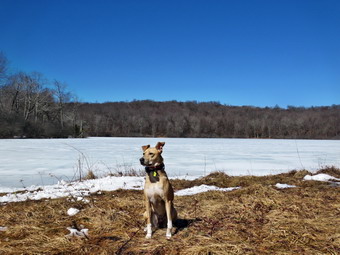 We continued straight ahead on the Flynn Trail instead of turning left on the Big Rock Trail or right on snowmobile trail. I had been a little tired climbing the Flynn Trail but was rejuvenated as the trail flattened out. We passed through the gate that separates state land from land owned by the Beaverkill Land Trust. When the trail split we stayed left to follow the Flynn Trail down to Hidge Pond. Almost immediately we came to a large patch of snow covering the rail. There did not seem to be an reason why there was so much snow in this area but there was. We walked over it and continued down to the pond. As we came to the spot where there the trail breaks out into the field at the outlet end of Hodge, there was a huge patch of snow. The snow blows off of the pond and collects in large drifts and this is what remained. As we came to the snow, we noticed a couple and there three dogs in the field. None of the dogs were on leashes and they seemed to be doing as they please ignoring their owners' commands. I put Sheena on her leash as one of the dogs came straight toward us. There is nothing quite like the feeling of a strange dog approaching. The owners were calling the dog which pais no attention. I used my poles to try to steer the dog away to no avail. Sheena did not seem to be bothered but I was annoyed by the lack of courtesy showed by the owners. They finally were able to get a hold on their dog's collar and we passed by each other. They mumbled a greeting which Lisa answer but I felt it best to remain silent! I walked with Sheena to the shore of the pond and got out my camera. It was 1:30 PM and we had hiked 2.4 miles in 1 hour and 10 minutes. The pond was slowly expanding in size as the beavers continued to build their dam. I took shot of the entire pond and some of the area that the beavers had impounded. Sheena sat near the shore and I took some shots.
 I grabbed all my gear and walked back to where Lisa was near the dam. I took pictures of the entire pond from here and then took shots of the dam. As I was taking pictures, I saw a man coming down the Flynn Trail in the opposite direction. He made his way to us on the flooded trail. Sheena followed my command to sit and stay. I spoke to the man who indicated he had hiked in the area before and really enjoyed it. We parted ways and I put the camera in my pack and we started back up the hill at 1:35 PM to retrace our steps to the car. The walk back up the hill often seems tedious but on this day it seemed to go quickly. Sheena as always was running uphill and the back to us many times. She we came to the top of the hill we stayed to the right to take the Flynn Trail. We passed through the gate again and then arrived at the junction with the big Rock Trail. It had been my intention to turn right to extend the hike but we contend straight ahead so that Lisa could get back for her important phone call. We set a fast pace as the Flynn Trail is primarily a descent on the way back. We did not stop at all and came passed through the gate and then continued straight ahead at the trail junction. From there we walked downhill on the wide woods road. We turned left on the trail just before the gate at the start of the road that was once the way t get to the Beech Mountain Boy Scout Camp. We followed the Flynn Trail to the parking area and were back at the car at 2:40 PM after hiking 5.0 miles in 2 hours and 20 minutes. The elevation gain was 810 feet. As we left the parking area, the temperature was 48 degrees.
![]()
![]()
![]()
![]()
![]() On Friday, March 20th, I really wanted to go for a hike as the weather forecast was for some sun and temperatures into the high 40's! I also wanted to start of spring the right way as winter had been largely a bust for hiking. I knew Sheena would be excited as it had been over 10 days since our last walk because of the weather and numerous ambulance calls. I knew I had ambulance coverage at least for a few hours. At 10:30 AM I asked Cindy if she wanted o hike at Frick Pond and she thought that was too far for her without knowing the route. I asked if she would like to hike the Parksville Rail Trail and she agreed. As we began to get ready the temperature on the back porch was 38 degrees but the skies were still overcast. I assumed most of the snow would be gone but I planned to take my spikes anyway. Sheena loves warm places and has a short coat but also seems to really like the snow. The Parksville Rail Trail is under three miles out and back but keeping a quick pace helps increase the difficulty as does the snow and ice. Sheena actually does get in about twice the mileage that I do as she forges ahead and then comes back! I have transitioned from using a leash all the time to using a GarmimSport PRO electronic collar which has many versatile settings and seems to do the job. This allows Sheena to roam and keeps me sane by not having to yank on her leash. It seems that Sheena likes hiking as she smells my clothes and then runs to sit by the door or wanders around my study watching me get dressed! On this day she could hardly contain herself! I got dressed in my Mammut crew shirt with a long-sleeved baselayer. I put on a pair of insulated hiking pants which seemed to have no maker's label attached. The pants fit well and seemed to have just the right insulation. For boots I decided to put on my Keen Durand hiking boots which fit well. I added a new pair of Xstance insoles in an effort to find the best support and cushioning for my feet. These insoles have shock absorbing gel pads, TPU arch support, and memory foam cushioning all wrapped in a breathable fabric. The insoles have been hyped by their manufacturer and seemed to be living up to their claims. I have recently bought several brands of socks and put on a pair of OTC socks from The Buffalo Wool Company. These socks are a mixture of Merino wool and bison fiber. They have a cushioned lower and a slighty thinner upper. I put on my Mammut hoody which has a lot of zippers to dump heat when needed. I grabbed a pair of Leki Micro Vario poles I have been using for some time because they are light and lock without slipping. I chose a light hat to cover my ears and a light pair of gloves. I remembered to wear my OR Crocodile gaiters to repel any snow or mud. I decided to take my pack as I could carry my camera and it added a little difficulty to an otherwise easy trail. I also thought ther3 might be good photographic opportunities. As we walked out to the car, the sky was sill overcast but there was some blue and the sun was peaking through. I put our gear in the back of the car and Sheena in the back seat and left Livingston Manor at 10:50 AM. I drove out Old Route 17 toward Parksville and turned left under the Quickway overpass onto Service Road. I drove toward Parksville and pulled into the parking area on the right side of the road just after Fox Mountain Rd. There were no cars parked in the lot when we arrived but as we were getting ready a truck pulled in. It was a Town of Liberty employee who was picking up garbage.I got out of the car and checked the trail to find the trail was largely clear of snow and ice. I made sure Sheena's ecollar was adjusted correctly and let her out of the car. When I opened the car door, Sheena came out like a shot and headed for the trail. We started on our hike at 11:10 AM with the temperature still at 38 degrees and the skies unchanged.
On Friday, March 20th, I really wanted to go for a hike as the weather forecast was for some sun and temperatures into the high 40's! I also wanted to start of spring the right way as winter had been largely a bust for hiking. I knew Sheena would be excited as it had been over 10 days since our last walk because of the weather and numerous ambulance calls. I knew I had ambulance coverage at least for a few hours. At 10:30 AM I asked Cindy if she wanted o hike at Frick Pond and she thought that was too far for her without knowing the route. I asked if she would like to hike the Parksville Rail Trail and she agreed. As we began to get ready the temperature on the back porch was 38 degrees but the skies were still overcast. I assumed most of the snow would be gone but I planned to take my spikes anyway. Sheena loves warm places and has a short coat but also seems to really like the snow. The Parksville Rail Trail is under three miles out and back but keeping a quick pace helps increase the difficulty as does the snow and ice. Sheena actually does get in about twice the mileage that I do as she forges ahead and then comes back! I have transitioned from using a leash all the time to using a GarmimSport PRO electronic collar which has many versatile settings and seems to do the job. This allows Sheena to roam and keeps me sane by not having to yank on her leash. It seems that Sheena likes hiking as she smells my clothes and then runs to sit by the door or wanders around my study watching me get dressed! On this day she could hardly contain herself! I got dressed in my Mammut crew shirt with a long-sleeved baselayer. I put on a pair of insulated hiking pants which seemed to have no maker's label attached. The pants fit well and seemed to have just the right insulation. For boots I decided to put on my Keen Durand hiking boots which fit well. I added a new pair of Xstance insoles in an effort to find the best support and cushioning for my feet. These insoles have shock absorbing gel pads, TPU arch support, and memory foam cushioning all wrapped in a breathable fabric. The insoles have been hyped by their manufacturer and seemed to be living up to their claims. I have recently bought several brands of socks and put on a pair of OTC socks from The Buffalo Wool Company. These socks are a mixture of Merino wool and bison fiber. They have a cushioned lower and a slighty thinner upper. I put on my Mammut hoody which has a lot of zippers to dump heat when needed. I grabbed a pair of Leki Micro Vario poles I have been using for some time because they are light and lock without slipping. I chose a light hat to cover my ears and a light pair of gloves. I remembered to wear my OR Crocodile gaiters to repel any snow or mud. I decided to take my pack as I could carry my camera and it added a little difficulty to an otherwise easy trail. I also thought ther3 might be good photographic opportunities. As we walked out to the car, the sky was sill overcast but there was some blue and the sun was peaking through. I put our gear in the back of the car and Sheena in the back seat and left Livingston Manor at 10:50 AM. I drove out Old Route 17 toward Parksville and turned left under the Quickway overpass onto Service Road. I drove toward Parksville and pulled into the parking area on the right side of the road just after Fox Mountain Rd. There were no cars parked in the lot when we arrived but as we were getting ready a truck pulled in. It was a Town of Liberty employee who was picking up garbage.I got out of the car and checked the trail to find the trail was largely clear of snow and ice. I made sure Sheena's ecollar was adjusted correctly and let her out of the car. When I opened the car door, Sheena came out like a shot and headed for the trail. We started on our hike at 11:10 AM with the temperature still at 38 degrees and the skies unchanged.
 The trail was bare with only a few patches of snow and it was a pleasure to be able to walk without worrying about getting a good place to plant your feet. Off her leash Sheena runs ahead of us a certain distance and then maintains that distance by waiting or increasing her pace. On this day she seemed to be very interested in the many game trails that had been under the snow. We were soon under the cover of the trees and the trail changed completely! Now it was covered from side to side with several inches of ice. The sides of the trail were bare in places and covered in snow in others. I considered donning my spikes but did not. Cindy had not brought her spikes with her and I thought she might ask to use mine but she never mentioned it. Sheena was enjoying the freedom of the hike and the various game tracks. She did not seem cold as she had on some previous hikes. I was happy I wore the Mammut hoody as I almost immediately began to feel warm and opened the front zipper and pit zips. The trail runs parallel to the Little Beaverkill and the new section of State Route 17. It follows the route of the O&W railroad and is very flat. Sheena was setting a quick pace and I didn't mind as long as she would listen and wait for us when necessary. The biggest change in the trail conditions was the mud pits that had opened up and the standing water on parts of the trail. This continued for much of the hike. I noticed that the noise from the stream was a roar and several views showed the water was high and running rapidly. We continued walking on the trail trying to negotiate the slippery and uneven surface. We came to the viewpoint just before the wooden walkways. This spot has a nice view down to the stream and I stopped to take a peek. I got out my camera and took pictures of the stream which was now open with no ice or snow but a decent water level. I also took a few shots of the trail to show the conditions. Cindy had started over the wooden walkway so I took a picture of her carefully picking her way across. I put the camera away and we walked across the wooden walkways which still had a thick ridge of ice. The area before the bridge had running water and more water was passing under the bridge. There were large patches of ice before, on, and after the bridge. There was also a large area of mud that after the bridge.
We came to the landslide that had brought down several trees that had been cut and cleared. This area also had open water and a lot of mud. As we approached the falls there was a significant increase in noise from the stream. The falls came into view. I looked at the path down to the stream bed. I really wanted to get down there to take pictures so I walked off the trail and began the decent on the path. The upper part still had some snow and I was able to dig my feet in. When I got to the lower third, the trail was mostly ice. The smart choice was to turn around and take pictures from above so I decided to continue down to the streambed. As I was descending I heard Cindy call out and Sheena headed back up the trail. I was in the middle of an icy patch so I just called Sheena and she returned. I had carefully worked my way down through the snow and ice but Sheena came roaring down without a problem. She is very sure-footed and has long nails for extra traction. I was able to negotiate the ice and make it down to a spot where I could take pictures. I dropped my pack and got out my camera. I took pictures of the entire falls and rapids. I took shots downstream. I finished by taking pictures of the falls and the rapids at different angles and zooms. Sheena jumped up on a rock and sat down which I assumed she was posing for pictures. I took some shots and then put away my camera. I worked my way back up the path with less trouble than I expected. I met Cindy at the picnic table. She told me she had called out because another hiker had come by with a golden retriever and she was worried about Sheena's reaction. I took some more pictures from above the falls. I had to be careful as the entire area was covered in ice.
As we got ready to leave to walk the rest of the trail, we saw the man and his dog coming back toward us. I put Sheena on her leash and we passed by each other with no problem. The other hiker commented at the difficulty of hiking on the icy surface and we both agreed! The remainder of the walk to the other end of the trail went quickly. Sheena took the lead which she sometimes is reluctant to do as there are sometimes dogs at the end of the trail. The large dog across the stream was absent. As we approached the end of the trail, the dogs that are usually outside barking were nowhere to be found! We tagged the end of the trail at 12:10 PM meaning it had taken us an hour to hike and for me to take pictures. We turned around to head back to the car. It seemed the temperature had increased a few more degrees which means the ice had started to melt forming a thin layer of water on top of the ice making it even more slippery. We walked carefully back toward the car with Sheena in the lead continuing to wander off trail. I placed my pole with some force to et a good bite in the ice. Sheena seemed fine and was not favoring any of her paws because of the cold. Within 10 minutes we passed by the falls and continued to push the pace which was slowed by the slippery ice. We soon came to the bridge and the walkways, where we carefully walked over the slippery surface. As we approached the end of the trail, I called Sheena and told her "With" which is the equivalent of "Heel". We arrived back at the car at 12:50 PM after hiking 3 miles in an hour and 40 minutes. The temperature was 48 degrees or 10 degrees higher than at the start. Sheena seemed fresh and I felt she could have hiked out and back on the trail another time.When we returned home, there had been no ambulance calls.